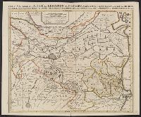
Based on Guillaume de L'Isle's Carte du Canada ... 1703., From Chatelain's Atlas historique ... Amsterdam : Chez L'Honoré & Châtelain, 1718-21., In upper right corner: Tom: VI. No: 20. Pag: 82., Includes text., Reli, and Sheet measures 45.3 x 57.1 cm.
Publisher:
Chez l'Honore & Chatelain Libraires,
Subject (Geographic):
Canada--Maps--Early works to 1800 and New France--Maps--Early works to 1800
"Avec privilege Janvier 1708.", "The words 'premier geographe du Roi' added in the title ... [indicate] that [a map] could not have been issued before 1718 when [De l'Isle] was appointed to that office"--Tooley, R.V. Guide to maps, and Relief shown pictorially.
Publisher:
chez l'auteur sur le Quai de l'Horloge,
Subject (Geographic):
Africa, Central--Maps--Early works to 1800 and Africa, Southern--Maps--Early works to 1800
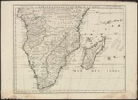
"Avec privil.", Backed with paper. Ms. no. "97" in upper right-hand corner. Sheet measures 53.6 x 63.5 cm. No. 87 of 87 maps bound together., Includes four bar scales., Includes inset: Carte particulière du Détroit de Magellan., Relief shown pictorially., and Untitled inset shows Southern Hemisphere.
Publisher:
Elizabeth Visscher,
Subject (Geographic):
Magellan, Strait of (Chile and Argentina)--Maps--Early works to 1800., South America--Maps--Early works to 1800., and Southern Hemisphere--Maps--Early works to 1800.
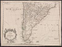
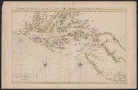
Appears in L'Isle's Atlas de géographie. Paris : Guillaume DeLisle, Quai de l'Horloge, 1731., Or, Relief shown pictorially., Sheet measures 54.9 x 74.6 cm., and Shows routes of Magellan, Sarmiento, Brower, Beauchesne, Sharp, Sr. de la Roche, Halley and Vespucci.
Publisher:
Chez l'auteur sur le Quai de l'Horloge ...,
Subject (Geographic):
South America--Maps--1708-1718 and South America--Maps--Early works to 1800
Subject (Name):
Liebaux, engraver, L'Isle, Guillaume de, 1675-1726. Atlas de géographie, and Simonneau, Charles, 1645-1728
Appears in L'Isle's Atlas de géographie. Paris : Guillaume DeLisle, Quai de l'Horloge, 1731., Imprint of Louis Renard Libraire, Mounted in linen. Sheet measures 51.8 x 69.7 cm., Ornamental cartouche by "C. Simonneau inv. et fecit.", and Relief shown pictorially.
Publisher:
Chez l'auteur sur le Quai de l'Horloge ...,
Subject (Geographic):
South America--Maps--1708-1718 and South America--Maps--Early works to 1800
Subject (Name):
Liebaux, engraver, L'Isle, Guillaume de, 1675-1726. Atlas de géographie, and Simonneau, Charles, 1645-1728
Anville, Jean Baptiste Bourguignon d', 1697-1782, cartographer.
Published / Created:
1719
Call Number:
3945 1719
Container / Volume:
BRBL_00193
Image Count:
2
Resource Type:
Maps, Atlases & Globes
Alternative Title:
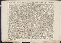
Theatre de la guerre d'Espagne
Description:
Imperfect: Left margin trimmed, with some loss of text. Sheets measure 55 x 76 cm. Versos: Nos. 151-152 in ink., Relief shown by hachures., and Watermarks.
Neptune françois, ou, Atlas nouveau des cartes marines.
Description:
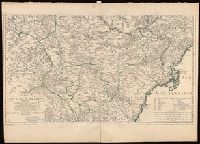
Appears in: Le Neptune françois, ou, Atlas nouveau des cartes marines, various eds., Covers coasts of Virginia, Maryland, Delaware, New, Described in Coolie Verner's Printed maps of Virginia, 1590-1800, p. 402., Nautical chart., and Oriented with north to right.
Publisher:
Chez P. Mortier,
Subject (Geographic):
Middle Atlantic States--Maps--Early works to 1800
Subject (Name):
Mortier, Pierre
Subject (Topic):
Coasts, Coasts--Delaware--Maps--Early works to 1800, Coasts--Maryland--Maps--Early works to 1800, Coasts--New Jersey--Maps--Early works to 1800, and Nautical charts--Chesapeake Bay (Md. and Va.)--Early works to 1800