Search
You Searched For
Search Results
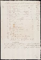
- Creator:
- Lewis, Meriwether, 1774-1809
- Published / Created:
- undated
- Call Number:
- WA MSS 303
- Collection Title:
- Lewis and Clark Expedition maps and receipt, ca. 1803-1810
- Container / Volume:
- Box 1 | Folder 3r
- Image Count:
- 1
- Found in:
- Beinecke Rare Book and Manuscript Library > "A Memorandum of Articles in readiness for the Voyage," manuscript list
- Creator:
- United States. Office of Strategic Services
- Published / Created:
- 1943
- Call Number:
- 36gma 1943
- Container / Volume:
- BRBL_00130
- Image Count:
- 1
- Resource Type:
- Maps, Atlases & Globes
- Found in:
- Beinecke Rare Book and Manuscript Library > "Greater Germany" inland waterways.
- Creator:
- United States. Office of Strategic Services
- Published / Created:
- 1945
- Call Number:
- 36cb 1945
- Container / Volume:
- BRBL_00127
- Image Count:
- 1
- Resource Type:
- Maps, Atlases & Globes
- Found in:
- Beinecke Rare Book and Manuscript Library > "Greater" Germany caves and cave regions.
- Creator:
- United States. Office of Strategic Services. Research and Analysis Branch
- Published / Created:
- 1945
- Call Number:
- 36eb 1945B
- Container / Volume:
- BRBL_00127
- Image Count:
- 1
- Resource Type:
- Maps, Atlases & Globes
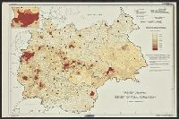
- Found in:
- Beinecke Rare Book and Manuscript Library > "Greater" Germany, density of total population by Kreise or similar units excluding cities 10,000 and over.
- Creator:
- United States. Office of Strategic Services. Research and Analysis Branch
- Published / Created:
- 1945
- Call Number:
- 36eb 1945C
- Container / Volume:
- BRBL_00127
- Image Count:
- 1
- Resource Type:
- Maps, Atlases & Globes
- Found in:
- Beinecke Rare Book and Manuscript Library > "Greater" Germany, density of total population by Kreise or similar units.
- Creator:
- United States. Office of Strategic Services. Research and Analysis Branch
- Published / Created:
- 1945
- Call Number:
- 36eb 1939A
- Container / Volume:
- BRBL_00127
- Image Count:
- 1
- Resource Type:
- Maps, Atlases & Globes
- Found in:
- Beinecke Rare Book and Manuscript Library > "Greater" Germany, population dependent upon commercial and service occupations (by Kreise 1939).
- Creator:
- United States. Office of Strategic Services. Research and Analysis Branch
- Published / Created:
- 1945
- Call Number:
- 36eb 1945A
- Container / Volume:
- BRBL_00127
- Image Count:
- 1
- Resource Type:
- Maps, Atlases & Globes
- Found in:
- Beinecke Rare Book and Manuscript Library > "Greater" Germany. : population change by Kreise, circa 1933-1939.
- Creator:
- United States. Office of Strategic Services. Research and Analysis Branch
- Published / Created:
- 1945
- Call Number:
- 36eb 1939
- Container / Volume:
- BRBL_00127
- Image Count:
- 1
- Resource Type:
- Maps, Atlases & Globes
- Found in:
- Beinecke Rare Book and Manuscript Library > "Greater" Germany; population dependent upon agriculture (by kreise, 1939)
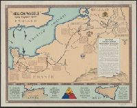
- Published / Created:
- [1944?]
- Call Number:
- 307hc 1944
- Container / Volume:
- BRBL_00036A
- Image Count:
- 1
- Resource Type:
- Maps, Atlases & Globes
- Found in:
- Beinecke Rare Book and Manuscript Library > "Hell on Wheels" 1942-1943-1944.
- Published / Created:
- 1759
- Call Number:
- OSB MSS 63
- Collection Title:
- William Shenstone papers
- Container / Volume:
- Box 1 | Folder 50
- Image Count:
- 4
- Resource Type:
- Archives or Manuscripts
- Found in:
- Beinecke Rare Book and Manuscript Library > "Leasowes farm as surveyed by Mr. William Lowe"
- Published / Created:
- [1874?]
- Call Number:
- 796gme 1874
- Container / Volume:
- BRBL_00531
- Image Count:
- 2
- Resource Type:
- Maps, Atlases & Globes
- Found in:
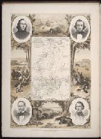
- Beinecke Rare Book and Manuscript Library > "Texas New Yorker's" railroad map of Texas : showing all completed and proposed routes, with principal rivers, county boundaries and county-seats, railroad stations and distances, congressional districts, United States military telegraph line, and frontie
- Creator:
- Sarony & Major
- Call Number:
- A52 030 1
- Collection Title:
- Ancient monuments of the Mississippi Valley: comprising the results of extensive original surveys
- Image Count:
- 1
- Found in:
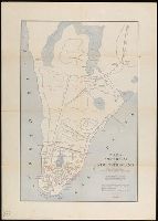
- Beinecke Rare Book and Manuscript Library > "The serpent;" (Entry 1014) Adams County Ohio. Pl. XXXV [35]
- Published / Created:
- 1817
- Call Number:
- 766 N46 1817
- Container / Volume:
- BRBL_00469A
- Image Count:
- 1
- Resource Type:
- Maps, Atlases & Globes
- Found in:
- Beinecke Rare Book and Manuscript Library > "To the mayor, aldermen & Common Council of the city of New Haven, this plan is ... dedicated by ... Amos Doolittle."
- Published / Created:
- [1824]
- Call Number:
- 766 N46 1824A
- Container / Volume:
- BRBL_00470
- Image Count:
- 1
- Resource Type:
- Maps, Atlases & Globes
- Found in:
- Beinecke Rare Book and Manuscript Library > "To the mayor, aldermen & Common Council of the city of New Haven, this plan is ... dedicated by ... Amos Doolittle."
- Published / Created:
- undated
- Call Number:
- WA MSS S-2962
- Collection Title:
- Northern Pacific Railway Company maps and drawings
- Container / Volume:
- Box 1 | Map 11
- Image Count:
- 1
- Resource Type:
- Maps, Atlases & Globes
- Found in:
- Beinecke Rare Book and Manuscript Library > (IDAHO & WASHINGTON) [Anon.] [Untitled map of northwestern Idaho and northeastern Washington].
- Creator:
- Gibboney, J. M
Kendrick, J. W
- Published / Created:
- 1890
- Call Number:
- WA MSS S-2962
- Collection Title:
- Northern Pacific Railway Company maps and drawings
- Container / Volume:
- Box 1 | Map 10
- Image Count:
- 2
- Resource Type:
- Maps, Atlases & Globes
- Found in:
- Beinecke Rare Book and Manuscript Library > (IDAHO) Kendrick, J. W., Surveyor. Map Showing Definite Location of the Spokane & Palouse Ry. (Lewiston Extension). From Julietta to Lewiston Idaho Territory. Distance 24-1/lO Miles. Drawn by J. M. Gibboney. Assistant Engineer's Office, Tacoma, Washington. Scale 1 in.=2000 ft.
- Published / Created:
- undated
- Call Number:
- WA MSS S-2962
- Collection Title:
- Northern Pacific Railway Company maps and drawings
- Container / Volume:
- 3 (Roll) | Map 24
- Image Count:
- 1
- Resource Type:
- Maps, Atlases & Globes
- Found in:
- Beinecke Rare Book and Manuscript Library > (MONTANA & IDAHO) [Anon.] [Untitled map of far northwestern Montana and a part of the Idaho panhandle.]
- Creator:
- Beckler, Eldridge H
Bischoff, A
- Published / Created:
- 1891 April 6
- Call Number:
- WA MSS S-2962
- Collection Title:
- Northern Pacific Railway Company maps and drawings
- Container / Volume:
- Box 1 | Map 34
- Image Count:
- 1
- Resource Type:
- Maps, Atlases & Globes
- Found in:
- Beinecke Rare Book and Manuscript Library > (MONTANA) Bischoff, A. Map of North- West part of Montana...Great Northern Line St. Paul, Minneapolis & Manitoba Ry. Pacific Extension. Elbridge H. Beckler, Chief Engineer. Helena, Mont. Scale 1 in.= 2 miles.
- Creator:
- Roberts. E.J
- Published / Created:
- 1887 August
- Call Number:
- WA MSS S-2962
- Collection Title:
- Northern Pacific Railway Company maps and drawings
- Container / Volume:
- Box 1 | Map 33
- Image Count:
- 2
- Resource Type:
- Maps, Atlases & Globes
- Found in:
- Beinecke Rare Book and Manuscript Library > (MONTANA) Roberts, E. J. Montana Extension. The Saint Paul, Minneapolis and Manitoba Ry. Co. Scale 12 miles to 1 inch.
- Published / Created:
- 1886
- Call Number:
- WA MSS S-2962
- Collection Title:
- Northern Pacific Railway Company maps and drawings
- Container / Volume:
- Box 1 | Map 31
- Image Count:
- 1
- Resource Type:
- Maps, Atlases & Globes
- Found in:
- Beinecke Rare Book and Manuscript Library > (MONTANA) [Anon.] Map of a Portion of Montana Territory.
- Published / Created:
- undated
- Call Number:
- WA MSS S-2962
- Collection Title:
- Northern Pacific Railway Company maps and drawings
- Container / Volume:
- Box 1 | Map 36
- Image Count:
- 1
- Resource Type:
- Maps, Atlases & Globes
- Found in:
- Beinecke Rare Book and Manuscript Library > (MONTANA) [Anon.] [Untitled map of a part of north central Montana.]
- Creator:
- Ordnance Survey of Great Britain and Ireland
Royal Geographical Society (Great Britain). Geographical Section
- Published / Created:
- 1915
- Call Number:
- 11hcf 1919E-5
- Container / Volume:
- BRBL_00010ZA
- Image Count:
- 1
- Resource Type:
- Maps, Atlases & Globes
- Found in:
- Beinecke Rare Book and Manuscript Library > (Vienna) Wien : North M 33. / compiled at the Royal Geographical Society under the direction of the Geographical Section ; drawn and printed by Ordnance Survey.
- Creator:
- Ordnance Survey of Great Britain and Ireland
Royal Geographical Society (Great Britain). Geographical Section
- Published / Created:
- 1918
- Call Number:
- 11hcf 1919E-6
- Container / Volume:
- BRBL_00010ZA
- Image Count:
- 1
- Resource Type:
- Maps, Atlases & Globes
- Found in:
- Beinecke Rare Book and Manuscript Library > (Vienna) Wien : North M 33. / compiled at the Royal Geographical Society under the direction of the Geographical Section ; drawn and printed by Ordnance Survey.
- Creator:
- Ordnance Survey of Great Britain and Ireland
Royal Geographical Society (Great Britain). Geographical Section
- Published / Created:
- 1915
- Call Number:
- 11hcf 1919E-5
- Container / Volume:
- BRBL_00010ZA
- Image Count:
- 1
- Resource Type:
- Maps, Atlases & Globes
- Found in:
- Beinecke Rare Book and Manuscript Library > (Vienna) Wien : North M 33. / compiled at the Royal Geographical Society under the direction of the Geographical Section ; drawn and printed by Ordnance Survey.
- Published / Created:
- 1891 September 10
- Call Number:
- WA MSS S-2962
- Collection Title:
- Northern Pacific Railway Company maps and drawings
- Container / Volume:
- Box 1 | Map 40
- Image Count:
- 1
- Resource Type:
- Maps, Atlases & Globes
- Found in:
- Beinecke Rare Book and Manuscript Library > (WASHINGTON) [Anon.] Sketch of Country North of Spokane Wash. Helena Mont.
- Creator:
- Ordnance Survey of Great Britain and Ireland
Royal Geographical Society (Great Britain). Geographical Section
- Published / Created:
- 1915
- Call Number:
- 11hcf 1919E-12
- Image Count:
- 1
- Resource Type:
- Maps, Atlases & Globes
- Found in:
- Beinecke Rare Book and Manuscript Library > (Warsaw) Varshava : North N. 34. / compiled at the Royal Geographical Society under the direction of the Geographical Section; drawn and printed by Ordnance Survey.
- Creator:
- Great Britain. Foreign Office
Justus Perthes (Firm : Gotha, Germany)
Moras, Ferdinand, 1821-1908
Petermann, A. (August Heinrich), 1822-1878
- Published / Created:
- 1854
- Call Number:
- Folio 296
- Image Count:
- 1
- Resource Type:
- Books, Journals & Pamphlets
- Found in:
- Beinecke Rare Book and Manuscript Library > ... An account of the progress of the expedition to Central Africa, performed by order of Her Majesty's Foreign office, under Messrs. Richardson, Barth, Overweg & Vogel, in the years 1850, 1851, 1852, and 1853. Consisting of maps and illustrations, with descriptive notes, constructed and comp. from official and private materials by Augustus Petermann ...
- Published / Created:
- [1730?]
- Call Number:
- 894 1730
- Container / Volume:
- BRBL_00659
- Image Count:
- 1
- Resource Type:
- Maps, Atlases & Globes
- Found in:
- Beinecke Rare Book and Manuscript Library > ... This draught. being part of ye Spanish & Musketor Shore & the Bay of Honduras with. ye Islands adjacent; ... by ... Samuel Penthalow.
- Published / Created:
- 1842
- Call Number:
- 32 Ox1 1842
- Container / Volume:
- BRBL_00052A
- Image Count:
- 1
- Resource Type:
- Maps, Atlases & Globes
- Found in:
- Beinecke Rare Book and Manuscript Library > 10 miles round Oxford. Printed by Day and Haghe ... London.
- Published / Created:
- 1850
- Call Number:
- 1976 Folio 96
- Collection Title:
- A new universal atlas containing maps of the various empires, kingdoms, states and republics of the
- Image Count:
- 1
- Resource Type:
- Maps, Atlases & Globes
- Found in:
- Beinecke Rare Book and Manuscript Library > 10. Map of Connecticut
- Creator:
- Smith, J. L
- Published / Created:
- 1886 c1882.
- Call Number:
- 774 P53 1886
- Container / Volume:
- BRBL_00500
- Image Count:
- 1
- Resource Type:
- Maps, Atlases & Globes
- Found in:
- Beinecke Rare Book and Manuscript Library > 12 miles around Philadelphia.
- Published / Created:
- [1909?]
- Call Number:
- 771 N49 1609
- Image Count:
- 1
- Resource Type:
- Maps, Atlases & Globes
- Found in:
- Beinecke Rare Book and Manuscript Library > 1609 The Island of Manhattan (Mannahtin) at the time of its discovery ... L.L. Coates Engr'g Co., N.Y.
- Creator:
- MacCoun, Townsend, 1845-1932
- Published / Created:
- ©1909.
- Call Number:
- 771 N49 1664
- Container / Volume:
- BRBL_00483
- Image Count:
- 1
- Resource Type:
- Maps, Atlases & Globes
- Found in:
- Beinecke Rare Book and Manuscript Library > 1653-1664 Amsterdam in New Netherland [cartographic material] : the city of the Dutch West India Company / by Townsend MacCoun ; L.L. Poates Engr'g. Co.
- Creator:
- MacCoun, Townsend, 1845-1932
- Published / Created:
- ©1909.
- Call Number:
- 771 N49 1730
- Container / Volume:
- BRBL_00484
- Image Count:
- 1
- Resource Type:
- Maps, Atlases & Globes
- Found in:
- Beinecke Rare Book and Manuscript Library > 1730 New York, the English Colonial city / by Townsend MacCoun ; L.L. Poates Engr'g. Co.
- Published / Created:
- [1909?]
- Call Number:
- 771 N49 1783
- Container / Volume:
- BRBL_00484
- Image Count:
- 1
- Resource Type:
- Maps, Atlases & Globes
- Found in:
- Beinecke Rare Book and Manuscript Library > 1783 Manhattan Island at the close of the Revolution showing the American City with its Landmarks ... Fortifications ... L.L. Poates Engr'g Co., N.Y.
- Creator:
- United States. Congress. House. Committee on the Public Lands
- Published / Created:
- [1878?].
- Call Number:
- 75 1878
- Container / Volume:
- BRBL_00406
- Image Count:
- 16
- Resource Type:
- Maps, Atlases & Globes
- Found in:
- Beinecke Rare Book and Manuscript Library > 1876 Centennial map of the United States and territories : showing the extent of public surveys, indian and military reservations, land grant R.R. rail roads, canals, cities, towns & other details / compiled from the official surveys of the General Land O
- Creator:
- Horký, Karel, 1879-1965
Lenhard, J
- Published / Created:
- c1917.
- Call Number:
- 30 1917B
- Container / Volume:
- BRBL_00032A
- Image Count:
- 1
- Resource Type:
- Maps, Atlases & Globes
- Found in:
- Beinecke Rare Book and Manuscript Library > 1914--1915--1916--1917--?? / drawn by J. Lenhard.
- Creator:
- Thomas Bros. Maps
- Published / Created:
- [1928]
- Call Number:
- 844 R524 1928
- Container / Volume:
- BRBL_00607
- Image Count:
- 2
- Resource Type:
- Maps, Atlases & Globes
- Found in:
- Beinecke Rare Book and Manuscript Library > 1928 map of Riverside / compiled & published by Thomas Bros.
- Creator:
- George F. Cram Company
- Published / Created:
- [1930]
- Call Number:
- 827 1930
- Container / Volume:
- BRBL_00577
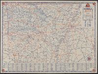
- Image Count:
- 2
- Resource Type:
- Maps, Atlases & Globes
- Found in:
- Beinecke Rare Book and Manuscript Library > 1930 census map of Oklahoma / George F. Cram Company, engravers and publishers.
- Creator:
- H.M. Gousha Company
- Published / Created:
- [1931]
- Call Number:
- 824gmb 1931
- Container / Volume:
- BRBL_00572
- Image Count:
- 2
- Resource Type:
- Maps, Atlases & Globes
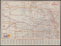
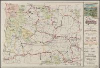
- Found in:
- Beinecke Rare Book and Manuscript Library > 1931 official road map, Nebraska / [prepared for] Shell.
- Creator:
- H.M. Gousha Company
- Published / Created:
- [1931]
- Call Number:
- 822gmb 1931
- Container / Volume:
- BRBL_00567
- Image Count:
- 2
- Resource Type:
- Maps, Atlases & Globes
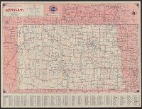
- Found in:
- Beinecke Rare Book and Manuscript Library > 1931 official road map, North Dakota / this map showing main trunk and highways is distributed with the compliments of Standard Oil Company (Indiana).
- Creator:
- Rand McNally and Company
- Published / Created:
- [1932]
- Call Number:
- 814gmb 1932
- Container / Volume:
- BRBL_00559
- Image Count:
- 2
- Resource Type:
- Maps, Atlases & Globes
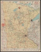
- Found in:
- Beinecke Rare Book and Manuscript Library > 1932 Texaco road map, Minnesota.
- Published / Created:
- [1932?], c1931.
- Call Number:
- 833gmb 1932
- Container / Volume:
- BRBL_00586
- Image Count:
- 2
- Resource Type:
- Maps, Atlases & Globes
- Found in:
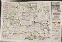
- Beinecke Rare Book and Manuscript Library > 1932 highway map of the state of Wyoming.
- Creator:
- Wyoming. State Highway Dept
- Published / Created:
- [1933]
- Call Number:
- 833gmb 1933
- Container / Volume:
- BRBL_00586
- Image Count:
- 2
- Resource Type:
- Maps, Atlases & Globes
- Found in:
- Beinecke Rare Book and Manuscript Library > 1933 highway map of the state of Wyoming / Wyoming State Highway Department.
- Creator:
- Rand McNally and Company
- Published / Created:
- [1934]
- Call Number:
- 818gmb 1934
- Container / Volume:
- BRBL_00565
- Image Count:
- 2
- Resource Type:
- Maps, Atlases & Globes
- Found in:
- Beinecke Rare Book and Manuscript Library > 1934 official road map, Arkansas / [prepared for] Gulf Refining Co.
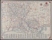
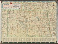
- Creator:
- Rand McNally and Company
- Published / Created:
- [1934]
- Call Number:
- 795gmb 1934
- Container / Volume:
- BRBL_00523
- Image Count:
- 2
- Resource Type:
- Maps, Atlases & Globes
- Found in:
- Beinecke Rare Book and Manuscript Library > 1934 official road map, Louisiana / [prepared for] Gulf Refining Co.
- Creator:
- H.M. Gousha Company
- Published / Created:
- [1934]
- Call Number:
- 841gmb 1934
- Container / Volume:
- BRBL_00597
- Image Count:
- 2
- Resource Type:
- Maps, Atlases & Globes
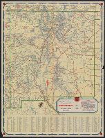
- Found in:
- Beinecke Rare Book and Manuscript Library > 1934 official road map, New Mexico / [prepared for] Phillips Petroleum Company.
- Creator:
- H.M. Gousha Company
- Published / Created:
- [1934]
- Call Number:
- 822gmb 1934
- Container / Volume:
- BRBL_00567
- Image Count:
- 2
- Resource Type:
- Maps, Atlases & Globes
- Found in:
- Beinecke Rare Book and Manuscript Library > 1934 official road map, North Dakota / compliments of Phillips Petroleum Company.
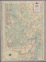
- Creator:
- H.M. Gousha Company
- Published / Created:
- 1937
- Call Number:
- 832gmb 1937
- Container / Volume:
- BRBL_00583
- Image Count:
- 2
- Resource Type:
- Maps, Atlases & Globes
- Found in:
- Beinecke Rare Book and Manuscript Library > 1937 road map, Idaho.