Search
You Searched For
Search Results
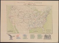
- Creator:
- National Highways Association
- Published / Created:
- 1913
- Call Number:
- 75gmb 1915B
- Container / Volume:
- BRBL_00411
- Image Count:
- 1
- Resource Type:
- Maps, Atlases & Globes
- Subject (Topic):
- Highway planning--United States--Maps
- Found in:
- Beinecke Rare Book and Manuscript Library > National highways system -- fifty thousand miles -- main trunk and link lines proposed by the National Highways Association / National Highways Association.
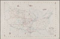
- Creator:
- Brayer, Garnet M
- Published / Created:
- 1949 [i.e. 1950]
- Call Number:
- 75gmb 1895
- Container / Volume:
- BRBL_00411
- Image Count:
- 1
- Resource Type:
- Maps, Atlases & Globes
- Subject (Topic):
- Cattle trade--United States--Maps
- Found in:
- Beinecke Rare Book and Manuscript Library > America's cattle trails. Compiled from contemporary sources by Garnet M. Brayer and Herbert O. Brayer; Hugh T. Glen, cartographer; C.O. Froid, illustrator.
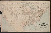
- Creator:
- American Telephone and Telegraph Company
- Published / Created:
- 1904
- Call Number:
- 75gmk 1904
- Container / Volume:
- BRBL_00414A
- Image Count:
- 1
- Resource Type:
- Maps, Atlases & Globes
- Subject (Topic):
- Telephone lines--United States--Maps
- Found in:
- Beinecke Rare Book and Manuscript Library > Map showing lines of the Bell telephone companies in the United States and Canada : July 1st, 1904 / American Telephone & Telegraph Company.
- Published / Created:
- 1909
- Call Number:
- 75cfe 1909
- Container / Volume:
- BRBL_00409
- Image Count:
- 1
- Resource Type:
- Maps, Atlases & Globes
- Subject (Geographic):
- United States--Maps
- Found in:
- Beinecke Rare Book and Manuscript Library > United States, Contour Map.
- Creator:
- Berthrong, I. P
- Published / Created:
- 1908
- Call Number:
- 75j 1908
- Container / Volume:
- BRBL_00414A
- Image Count:
- 1
- Resource Type:
- Maps, Atlases & Globes
- Subject (Geographic):
- United States--Maps
- Subject (Topic):
- Explorers--United States--Maps
- Found in:
- Beinecke Rare Book and Manuscript Library > United States showing routes of principal explorers and early roads and highways [map] / from data prepared by Frank Bond ; by I. B. Berthrong.
- Creator:
- Berthrong, I. P
- Published / Created:
- 1908
- Call Number:
- 75gmb 1908
- Container / Volume:
- BRBL_00411
- Image Count:
- 1
- Resource Type:
- Maps, Atlases & Globes
- Subject (Geographic):
- United States--Maps
- Subject (Topic):
- Explorers--United States--Maps
- Found in:
- Beinecke Rare Book and Manuscript Library > United States showing routes of principal explorers and early roads and highways [map] / from data prepared by Frank Bond ; by I. B. Berthrong.
- Creator:
- Berthrong, I. P
- Published / Created:
- 1908
- Call Number:
- 75j 1908
- Container / Volume:
- BRBL_00414A
- Image Count:
- 1
- Resource Type:
- Maps, Atlases & Globes
- Subject (Geographic):
- United States--Maps
- Subject (Topic):
- Explorers--United States--Maps
- Found in:
- Beinecke Rare Book and Manuscript Library > United States showing routes of principal explorers and early roads and highways [map] / from data prepared by Frank Bond ; by I. B. Berthrong.
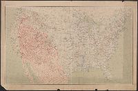
- Creator:
- United States. Office of Farm Management
- Published / Created:
- 1915
- Call Number:
- 75gce 1915
- Container / Volume:
- BRBL_00410
- Image Count:
- 1
- Resource Type:
- Maps, Atlases & Globes
- Subject (Geographic):
- United States--Maps
- Subject (Topic):
- Irrigation--United States--Maps
- Found in:
- Beinecke Rare Book and Manuscript Library > Irrigation map of the United States / engraved and printed by the U.S. Geological Survey ; outline of irrigated areas based upon data collected by the Bureau of the Census, 1910 ; revised by Irrigation Division, Office of Experimental Stations, and by the
- Creator:
- National Highways Association
- Published / Created:
- c1914.
- Call Number:
- 75gmb 1915A
- Container / Volume:
- BRBL_00411
- Image Count:
- 1
- Resource Type:
- Maps, Atlases & Globes
- Subject (Topic):
- Roads--United States--Maps
- Found in:
- Beinecke Rare Book and Manuscript Library > Fifty thousand miles of national highways proposed by the National Highways Association / published under direction of the National Highways Association ; John C. Mulford, cartographer.
- Published / Created:
- 1919
- Call Number:
- 75gmb AL14 1919
- Container / Volume:
- BRBL_00411
- Image Count:
- 1
- Resource Type:
- Maps, Atlases & Globes
- Subject (Topic):
- Roads--United States--Maps
- Found in:
- Beinecke Rare Book and Manuscript Library > Map of the Albert Pike Highway : showing every city, town, village and hamlet throughout its entire length / proposed by the Albert Pike Highway Association.