Search
You Searched For
Search Results
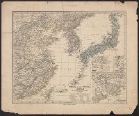
- Creator:
- Rand McNally and Company
- Published / Created:
- c1901.
- Call Number:
- 56 1901A
- Container / Volume:
- BRBL_00296
- Image Count:
- 2
- Resource Type:
- Maps, Atlases & Globes
- Subject (Geographic):
- Korea--Maps
- Subject (Topic):
- Transportation--Korea--Maps
- Found in:
- Beinecke Rare Book and Manuscript Library > A new map of the Chinese Empire with Japan and Korea. Map of Asia. / by Rand, McNally & Co.
- Creator:
- Speed, John, 1552?-1629
- Call Number:
- Lanman 50 1676
- Image Count:
- 2
- Resource Type:
- Maps, Atlases & Globes
- Description:
- . China] and Corea Isle [i.e. Korea]. One
- Found in:
- Beinecke Rare Book and Manuscript Library > A newe mape of Tartary / augmented by John Speed and are to be sold by Tho. Bassett in Fleet Street & Richard Chiswell in St. Pauls Churchyard ; Dirck Grÿp, sculp.
- Creator:
- United States. Hydrographic Office
- Published / Created:
- 1904
- Call Number:
- 57 1904
- Container / Volume:
- BRBL_00302
- Image Count:
- 1
- Resource Type:
- Maps, Atlases & Globes
- Subject (Geographic):
- Korea--Maps
- Found in:
- Beinecke Rare Book and Manuscript Library > Asia, Japan and Korea : with the surrounding seas and the adjacent coastal region of China / published at Washington, D.C. Feb. 1904, at the Hydrographic Office. H.M. Hodges, Lieutenant Commander, U.S.N. Hydrographer.
- Creator:
- United States. Hydrographic Office
- Published / Created:
- 1904
- Call Number:
- 556cea 1904
- Container / Volume:
- BRBL_00293
- Image Count:
- 1
- Resource Type:
- Maps, Atlases & Globes
- Subject (Geographic):
- Korea--Maps
- Found in:
- Beinecke Rare Book and Manuscript Library > Asia, Japan and Korea : with the surrounding seas and the adjacent coastal region of China / published at Washington, D.C. Feb. 1904, at the Hydrographic Office. H.M. Hodges, Lieutenant Commander, U.S.N. Hydrographer.
- Published / Created:
- [Late Chosŏn i.e. 18th century]
- Call Number:
- YAJ K4.1
- Image Count:
- 22
- Abstract:
- An atlas of Korea. This is an atlas of
- Found in:
- Beinecke Rare Book and Manuscript Library > Chidoch'ŏp, [Late Chosŏn i.e. 18th century].
- Creator:
- Petermann, A. (August), 1822-1878
- Published / Created:
- 1877
- Call Number:
- 56 1877
- Container / Volume:
- BRBL_00296
- Image Count:
- 1
- Resource Type:
- Maps, Atlases & Globes
- Alternative Title:
- China (östlicheTheil), Korea und Japan
- Subject (Geographic):
- Korea--Maps
- Found in:
- Beinecke Rare Book and Manuscript Library > China (östl. Theil), Korea und Japan im Massstab 1:7.500.000 / von A. Petermann ; bearbeitet von Ernst Debes ; gestochen v. H. Eberhardt ; Terrain v. C. Jungmann.
- Published / Created:
- 1774
- Call Number:
- 56 1774
- Container / Volume:
- BRBL_00295
- Image Count:
- 1
- Resource Type:
- Maps, Atlases & Globes
- Description:
- Includes Korea.
- Found in:
- Beinecke Rare Book and Manuscript Library > China divided into its great provinces and the Isles of Japan by Samuel Dunn.
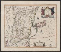
- Creator:
- Jansson, Jan, 1588-1664, cartographer
- Call Number:
- 56 1636
- Container / Volume:
- BRBL_00294
- Image Count:
- 2
- Resource Type:
- Maps, Atlases & Globes
- Subject (Geographic):
- Korea--Maps--Early works to 1800
- Found in:
- Beinecke Rare Book and Manuscript Library > China veteribus Sinarum Regio nunc incolis Tame dicta.
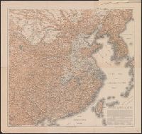
- Creator:
- Geological Survey (U.S.). Topographic Branch
- Published / Created:
- 1921
- Call Number:
- 56fd 1921
- Container / Volume:
- BRBL_00298
- Image Count:
- 1
- Resource Type:
- Maps, Atlases & Globes
- Description:
- Also shows railways in Japan, Korea
- Found in:
- Beinecke Rare Book and Manuscript Library > General map of China and adjacent regions showing treaty ports and railroads / prepared for the Department of State by the Topographic Branch, U.S. Geological Survey, 1921.
- Creator:
- Hoebel, Paul
- Published / Created:
- 1910
- Call Number:
- 56 1901
- Container / Volume:
- BRBL_00296
- Image Count:
- 4
- Resource Type:
- Maps, Atlases & Globes
- Subject (Geographic):
- Korea--Maps
- Found in:
- Beinecke Rare Book and Manuscript Library > Hoebels Karte v. China [cartographic material] / gezeichnet und übersetzt von Paul Hoebel, Terrainzeichnung von F. Pilger.