Skip to search
Skip to main content
Skip to first result
Search
You Searched For
Genre
Annotations (Provenance)--18th century
Search Results
Creator:
Published / Created:
1755
Call Number:
755 1755M
Container / Volume:
BRBL_00427
Image Count:
1
Resource Type:
Maps, Atlases & Globes
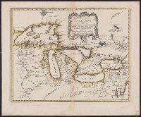
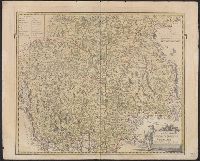
Abstract:
Shows Great Lakes region.
Description:
Copy 1: Borders of lakes and frame of map colored in yellow. Backed with linen. Stamp: Thorne Collection of Cartography and Geography. Stamp: Karpinski-von Wieser Map Collection.
Publisher:
[Homann Erben?],
Subject (Geographic):
Canada--Maps--Early works to 1800, Great Lakes Region (North America)--Maps--Early works to 1800, and New France--Maps--Early works to 1800
Subject (Name):
Homann Erben (Firm) and Thorne Collection of Cartogaphy and Geography Stamp
Found in:
Beinecke Rare Book and Manuscript Library > Partie occidentale de la Nouvelle France ou du Canada / par Mr. Bellin, ingenieur du Roy et de la Marine, pour seruir à l'intelligence des affaires et de l'etat present en Amerique, communiquée au public par les Heritiers de Homanen l'an 1755.
Creator:
Published / Created:
1755
Call Number:
755 1755M
Container / Volume:
BRBL_00427
Image Count:
1
Resource Type:
Maps, Atlases & Globes
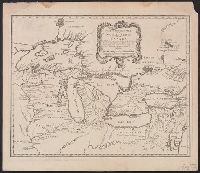
Abstract:
Shows Great Lakes region.
Description:
Copy 2: Stamp: Yale Horace Brown 1900S. Manuscript note in unidentified hand.
Publisher:
[Homann Erben?],
Subject (Geographic):
Canada--Maps--Early works to 1800, Great Lakes Region (North America)--Maps--Early works to 1800, and New France--Maps--Early works to 1800
Subject (Name):
Brown, Horace--Stamp and Homann Erben (Firm)
Found in:
Beinecke Rare Book and Manuscript Library > Partie occidentale de la Nouvelle France ou du Canada / par Mr. Bellin, ingenieur du Roy et de la Marine, pour seruir à l'intelligence des affaires et de l'etat present en Amerique, communiquée au public par les Heritiers de Homanen l'an 1755.
Creator:
Published / Created:
1745
Call Number:
73 1745
Container / Volume:
BRBL_00688
Image Count:
1
Resource Type:
Maps, Atlases & Globes
Description:
"Longitude du meridien de l'Isle de Fer."
Publisher:
Dépot de la Marine],
Subject (Geographic):
Canada--Maps--Early works to 1800
Subject (Name):
Bellin, Jacques Nicolas, 1703-1772. Atlas maritime
Found in:
Beinecke Rare Book and Manuscript Library > Partie orientale de la Nouvelle France ou du Canada / [cartographic material] / par Mr. Bellin, Ingenieur du Roy et de la marine.
Creator:
Published / Created:
1745
Call Number:
755 1745A
Container / Volume:
BRBL_00426
Image Count:
1
Resource Type:
Maps, Atlases & Globes
Description:
"Longitude du meridien de l'Isle de Fer."
Publisher:
Dépot de la Marine],
Subject (Geographic):
Canada--Maps--Early works to 1800
Subject (Name):
Bellin, Jacques Nicolas, 1703-1772. Atlas maritime and Thorne Collection of Cartogaphy and Geography Stamp
Found in:
Beinecke Rare Book and Manuscript Library > Partie orientale de la Nouvelle France ou du Canada / [cartographic material] / par Mr. Bellin, Ingenieur du Roy et de la marine.
Creator:
Call Number:
39hc Sa54 1719
Container / Volume:
BRBL_00192
Image Count:
1
Resource Type:
Maps, Atlases & Globes
Description:
"Military Depot"--Stamp. Manuscript note in unidentified hand.
Subject (Geographic):
San Sebastián (Spain)--History, Military--18th century--Maps--Early works to 1800 and San Sebastián (Spain)--Maps--Early works to 1800
Subject (Name):
Military Depot Stamp
Found in:
Beinecke Rare Book and Manuscript Library > Plan de St. Sebastien et de ses environs : capitalle de la province de Gupuzcoa : attaqué par l'armée du Roy commande par le Marechal Duc de Barwick le 19 Juillet 1719.
Creator:
Published / Created:
between 1716 and 1737?]
Call Number:
71 1737B
Container / Volume:
BRBL_00725
Image Count:
1
Resource Type:
Maps, Atlases & Globes
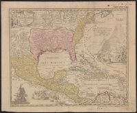
Description:
Appears in Homann's Atlas geographicus major ... Normibergae : Curantibus Homannianis heredibus, 1759.
Publisher:
[Homann Erben?,
Subject (Geographic):
New Spain--Maps--Early works to 1800 and North America--Maps--Early works to 1800
Subject (Name):
Homann Erben (Firm) and Homann, Johann Baptist, 1663-1724. Atlas geographicus major
Found in:
Beinecke Rare Book and Manuscript Library > Regni Mexicani seu Novae Hispaniae, Ludovicianae, N. Angliae, Carolinae, Virginiae et Pensylvaniae necnon insularum archipelagi Mexicani in America Septentrionali / accurata tabula exhibita â Ioh. Baptista Homanno.
Creator:
Published / Created:
between 1716 and 1737?]
Call Number:
71 1716
Container / Volume:
BRBL_00361
Image Count:
1
Resource Type:
Maps, Atlases & Globes
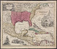
Description:
Appears in Homann's Atlas geographicus major ... Normibergae : Curantibus Homannianis heredibus, 1759.
Publisher:
[Homann Erben?,
Subject (Geographic):
New Spain--Maps--Early works to 1800 and North America--Maps--Early works to 1800
Subject (Name):
Homann Erben (Firm) and Homann, Johann Baptist, 1663-1724. Atlas geographicus major
Found in:
Beinecke Rare Book and Manuscript Library > Regni Mexicani seu Novae Hispaniae, Ludovicianae, N. Angliae, Carolinae, Virginiae et Pensylvaniae necnon insularum archipelagi Mexicani in America Septentrionali / accurata tabula exhibita â Ioh. Baptista Homanno.
Creator:
Published / Created:
MDCCLII [1752]
Call Number:
556 1752
Image Count:
1
Resource Type:
Maps, Atlases & Globes
Alternative Title:
Carte d'Asie
Description:
"Avec privilege."
Publisher:
Chez l'Auteur aux Galerie du Louvre,
Subject (Geographic):
Asia--Maps--Early works to 1800.
Subject (Name):
Anville, Jean Baptiste Bourguignon d', 1697-1782. Atlas général. and Haye, G. de la
Found in:
Beinecke Rare Book and Manuscript Library > Seconde partie de la carte d'Asie : contenant la Chine, et partie de la Tartarie, l'Inde au delà du Gange, les isles Sumatra, Java, Borneo, Moluques, Philippines et du Japon : publiée sous les auspices de Monsigneur Louis Phillippe D'Orléans, Duc D'Orl
Creator:
Published / Created:
[ca. 1762?]
Call Number:
4035 1762
Container / Volume:
BRBL_00234
Image Count:
1
Resource Type:
Maps, Atlases & Globes
Description:
Bar scales given in "milliaria duo Germanica" and "milliaria Italica."
Publisher:
Edentibus Homannianis Hered., C.P.S.C.M.,
Subject (Geographic):
Trentino-Alto Adige (Italy)--Maps--Early works to 1800 and Tyrol (Austria)--Maps--Early works to 1800
Subject (Name):
Homann Erben (Firm)
Found in:
Beinecke Rare Book and Manuscript Library > Tyrolis pars meridionalis cum Espicopatu Tridentino finitimisque vallibus et limitibus Venetis / accurate descripta a Iosepho de Spergs in Palenz et Reisdorf.
Call Number:
4035 1780
Container / Volume:
BRBL_00234
Image Count:
1
Resource Type:
Maps, Atlases & Globes
Description:
Imperfect: Mutilated with slight loss of information. Hand colored. Stamp: Karpinski-von Wieser Map Collection. "58"--Manuscript note in unidentified hand.
Subject (Geographic):
Trentino-Alto Adige (Italy)--Maps--Early works to 1800
Found in:
Beinecke Rare Book and Manuscript Library > Tyrolis pars meridionalis, episcopatum, et principatum Tridentinum continens.