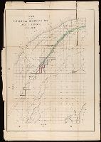
Shows railroads, corporate land ownership, plats of Marquette and Negaunee, sawmill locations in all or parts of sections T.47-48 N, R. 25-27 W.
Description:
Backed with linen. Manuscript annotations on map. Manuscript title on verso: Marquette Iron Region. From the Richard H. Rickard Papers., Coordinates not present on map and are approximated., Detached from: A statement of the plan of the St. Mary's Canal Mineral Land Company (New York : Baker & Godwin, printers, 1859)., and Relief shown by hachures.
Publisher:
[Baker & Godwin, printers],
Subject (Geographic):
Michigan--Upper Peninsula
Subject (Name):
Collins Iron Company--Maps., Excelsior Iron Company--Maps., Jackson Iron Company (Fayette, Mich.)--Maps., Peninsula Iron Company--Maps., Pioneer Iron Company--Maps., and Rickard, Richard H.,---1885--Owner