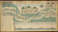
Генеральной планъ Боровицкимъ порогамъ отъ Опеченской до Потерпельской пристани ...
Description:
Coordinates cannot be determined., Includes illustration and inset listing distances between various locations., Manuscript annotaions on verso., and Relief shown pictorially.
Subject (Geographic):
Novgorodskai︠a︡ oblastʹ (Russia)--Maps--Early works to 1800.
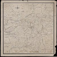
In manuscript on map: Kapitan" Matveĭ Loginov"; on verso: Ural-Gebiet, zwischen Kasan u. Jekaterinburg; stampf of the Königliches Kartographisches Institut, Berlin., Relief shown pictorially and by spot heights., and Title devised by cataloger.
Subject (Geographic):
Orenburgskai︠a︡ oblastʹ (Russia)--Maps--Early works to 1800. and Ural Mountains (Russia)--Maps--Early works to 1800.