Skip to search
Skip to main content
Skip to first result
Search
You Searched For
Genre
Atlases
Genre
Hand coloring
Subject (Topic)
Atlases, German --Early works to 1800
New Search
Search Results
Creator:
Published / Created:
1746
Call Number:
1973 Folio 30
Collection Title:
[Atlas factice of 32 maps and 1 distance table, produced by the Homann Erben firm]
Image Count:
1
Alternative Title:
Mappe-monde qui represente les deux hemispheres savoir celui de l’orient et celui de l’occident, tiree des quatre cartes generales de feu M. le profess. Hasius, dressee par Mr. G.M. Lowitz et publiee par les Heritiers de Homann and Planiglobii terrestris mappa vniversalis
Description:
Map colored to show distribution of religions.
Publisher:
[Homann Erben]
Subject (Topic):
Atlases, German --Early works to 1800, Religion --Maps --Early works to 1800, and World maps --Early works to 1800
Collection Created:
[Nuremberg : s.n.,
Found in:
Beinecke Rare Book and Manuscript Library > Planiglobii terrestris mappa universalis utrumq[ue] hemisphaerium orient. et occidentale repraesentans, ex IV. mappis generalibus, Hasianis composita et adjectis ceteris hemisphaeriis / [cartographic material] / designata a G.M. Lowizio ; excudentibus Hom
Creator:
Published / Created:
1732
Call Number:
1975 Folio 31
Collection Title:
[Atlas factice of 42 maps, produced by the Homann Erben firm]
Image Count:
1
Alternative Title:
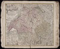
Tabula ad geographiam Huebnerianam recentissime recognita nec minus passim auota et religionum simul distinctione illustrata per Homannianos Heredes anno 1732
Publisher:
[Homann Erben]
Subject (Geographic):
Switzerland --Maps --Early works to 1800
Subject (Topic):
Atlases, German --Early works to 1800
Collection Created:
[Nuremberg,
Found in:
Beinecke Rare Book and Manuscript Library > Potentissimae Helvetiorum Reipublicae cantones tredecim cum foederatis et subjectis provinciis / exhibiti a Ioh. Baptista Homanno
Creator:
Published / Created:
1742?
Call Number:
1975 Folio 31
Collection Title:
[Atlas factice of 42 maps, produced by the Homann Erben firm]
Image Count:
1
Alternative Title:
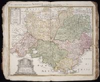
Praefectura Generalis et Comitatus Provinciae
Subject (Geographic):
Alpes de Haute-Provence (France) --Maps --Early works to 1800, Alpes-Maritimes (France) --Maps --Early works to 1800, Bouches-du-Rhone (France) --Maps --Early works to 1800, France, Southern --Maps --Early works to 1800, Var (France) --Maps --Early works to 1800, and Vaucluse (France : Dept.) --Maps --Early works to 1800
Subject (Topic):
Atlases, German --Early works to 1800
Collection Created:
[Nuremberg,
Found in:
Beinecke Rare Book and Manuscript Library > Praefectura Generalis & Comitatus Provinciae una cum Terris adjacentibus in suas Dioeceses & Praeturas subdivisus ad prototypum del Islianum / [cartographic material] / excusus studion Homannianorum Heredum
Creator:
Published / Created:
[ca. 1758]
Call Number:
1973 Folio 30
Collection Title:
[Atlas factice of 32 maps and 1 distance table, produced by the Homann Erben firm]
Image Count:
2
Publisher:
Anjezo im Verlag bey Tob. Conr. Lotter, Geogr
Subject (Geographic):
Altenburg (Germany : Landkreis) --Maps --Early works to 1800 and Greiz (Germany : Landkreis) --Maps --Early works to 1800
Subject (Topic):
Atlases, German --Early works to 1800
Collection Created:
[Nuremberg : s.n., 1701-1760]
Found in:
Beinecke Rare Book and Manuscript Library > Praefecturae Altenburgensis et Ronneburgensis earumque vicinia serenissimo Duci Saxo Gothano parentes geographica tabula / [cartographic material] / expressae a Matthaeo Seuttero, Geograph. Caesar
Creator:
Published / Created:
ca. 1715
Call Number:
1975 Folio 31
Collection Title:
[Atlas factice of 42 maps, produced by the Homann Erben firm]
Image Count:
1
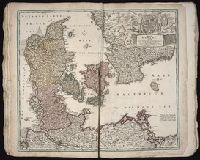
Publisher:
Johann Baptist Homann
Subject (Geographic):
Denmark --Maps --Early works to 1800
Subject (Topic):
Atlases, German --Early works to 1800
Collection Created:
[Nuremberg,
Found in:
Beinecke Rare Book and Manuscript Library > Regni Daniae, in quo sunt Ducatus Holsatia et Slesvicum, insulae Danicae, provinciae Iutia, Scania, Bleckingia, nova tabula / [cartographic material] / edita a Io. Baptista Homanno ; et aucta secundum geographiam novissimam Iohann Huebneri, I.U.L
Creator:
Published / Created:
173-?
Call Number:
1973 Folio 30
Collection Title:
[Atlas factice of 32 maps and 1 distance table, produced by the Homann Erben firm]
Image Count:
2
Publisher:
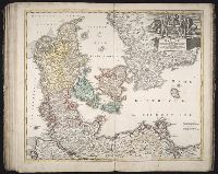
[Johann Baptist Homann]
Subject (Geographic):
Denmark --Maps --Early works to 1800
Subject (Topic):
Atlases, German --Early works to 1800
Collection Created:
[Nuremberg : s.n., 1701-1760]
Found in:
Beinecke Rare Book and Manuscript Library > Regni Daniae, in quo sunt Ducatus Holsatia et Slesvicum, insulae Danicae, provinciae Iutia, Scania, Bleckingia, nova tabula [cartographic material] / edita a Io. Baptista Homanno ; et aucta secundum geographiam novissimam Iohann Huebneri, J.U.L
Creator:
Published / Created:
1741
Call Number:
1975 Folio 31
Collection Title:
[Atlas factice of 42 maps, produced by the Homann Erben firm]
Image Count:
1
Alternative Title:
Carte de France dressee par Guillaume de L’Isle et accommodee par les Heritiers d’Homann
Publisher:
Homann Erben
Subject (Geographic):
France --Maps --Early works to 1800
Subject (Topic):
Atlases, German --Early works to 1800
Collection Created:
[Nuremberg,
Found in:
Beinecke Rare Book and Manuscript Library > Regni Galliae seu Franciae et Navarrae [cartographic material] : tabula geographica in usum elementorum geographiae schazianorum accom[m]odata / per Homannianos Heredes
Creator:
Published / Created:
1741
Call Number:
1973 Folio 30
Collection Title:
[Atlas factice of 32 maps and 1 distance table, produced by the Homann Erben firm]
Image Count:
2
Alternative Title:
Carte de France dressee par Guillaume de L’Isle et accommodee par les Heritiers d’Homann
Publisher:
[Homann Erben]
Subject (Geographic):
France --Maps --Early works to 1800
Subject (Topic):
Atlases, German --Early works to 1800
Collection Created:
[Nuremberg : s.n.,
Found in:
Beinecke Rare Book and Manuscript Library > Regni Galliae seu Franciae et Navarrae [cartographic material] : tabula geographica in usum elementorum geographiae schazianorum accom[m]odata / per Homannianos Heredes
Creator:
Published / Created:
1739
Call Number:
1975 Folio 31
Collection Title:
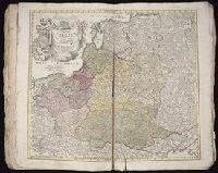
[Atlas factice of 42 maps, produced by the Homann Erben firm]
Image Count:
1
Publisher:
[Homann Erben]
Subject (Geographic):
Baltic States --Maps --Early works to 1800 and Poland --Maps --Early works to 1800
Subject (Topic):
Atlases, German --Early works to 1800
Collection Created:
[Nuremberg,
Found in:
Beinecke Rare Book and Manuscript Library > Regni Poloniae magnique Ducatus Lithuaniae / [cartographic material] / nova et exacta tabula ad mentem Starovolcii descripta a Iohanne Bapt. Homanno, Sac. Caes. Mai. Geographo
Creator:
Published / Created:
[1750?]
Call Number:
1975 Folio 31
Collection Title:
[Atlas factice of 42 maps, produced by the Homann Erben firm]
Image Count:
1
Publisher:
Impensis Homan[n]ianorum Heredum
Subject (Geographic):
China --Maps --Early works to 1800
Subject (Topic):
Atlases, German --Early works to 1800
Collection Created:
[Nuremberg,
Found in:
Beinecke Rare Book and Manuscript Library > Regni sinae vel sinae propriae, mappa et descriptio geographica ex mappis particularibus quas sinarum rex Canghi opera patrum missionariorum e S.I. in provincias regni universi ejus rei gratia ablegatorum concinnari fecit perfecta publicoque primum commun
Branch:v1.61.8 ,Deployed:2024-06-20T11:15:15-04:00