Course of the river Mississippi from the Balise to Fort Chartres
Description:
From Thomas Jeffery's The American atlas. 1775. Also published in Faden's North America Atlas, 1777., Imperfect: torn along fold. Title in manuscript on verso., Map of the Mississippi River Valley from the Gulf of Mexico to Fort Chartres, Illinois. Covers the Mississippi Valley from the Delta of the Mississippi where it joins the Gulf of Mexico to Fort Chartres., Prime meridian: New Orleans., Relief shown pictorially and by hachures. Depths shown by soundings., Scale of "Sea Leagues, 20 to a Degree"; and "British Miles, 69 1/2 to a Degree" below the imprint., Second issue. The first issue appeared in 1772. This 1775 issue has many changes in the area around New Orleans including the addition of forts St. Leon and St. Mary. Shows Baton Rouge and Lake Pontchartrain., The first official English survey of the Lower Mississippi, and one of the most historically significant American maps, delineating the British gains from France in the French and Indian War and later establishing the future western boundary of the new United States., The map includes detail of the lands to the immediate east of the Mississippi including numerous tributary rivers: the Pearl River, the Yasous River, the Chickasaw River, and the Ohio River. The locations of tribal lands and villages are noted, as well as alliances, roads to reach the villages, and the number of soldiers for several villages. Some tribes delineated in the map include the Arkansas, Chocktaw, Chicasaw, Yazoo, Wiapes, and Caskaskias., and Watermark.
Publisher:
Printed for Robt. Sayer, No. 53 in Fleet Street. Publishd as the Act directs,
Subject (Geographic):
Mississippi River Valley--Maps--Early works to 1800. and Mississippi River--Maps--Early works to 1800.
Subject (Name):
Jefferys, Thomas, -1771. American atlas. and Sayer, Robert, 1725-1794
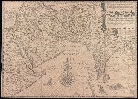
Afbeeldinge der custen van Abex, der engte van Mecha, anders ghenaempt de Roode Zee, Item de custen van Arabien, Ormus, Persen tot Sinde toe and Deliniantur in hac tabula, Orae maritimae Abexiae, freti Mecani ; al. Maris Rubri ; Arabiae, Ormi, Persiae, suprà Sindam usque Fluminis Indi, Cambaiae Indiae et Malabaris, Insulae Ceylon, Choromandeliae, et Orixae, fluvii Gangis, et Regni Bengalae, situs item Sinuum, Insularum
Description:
Backed with paper., From the author's Itinerario, voyage ofte schipvaert van Jan Huygen van Linschoten naer Oost ofte Portugaels Indien., Includes decorative cartouche and compass rose., Relief shown pictorially., and Title in Latin and Dutch. Place names in Latin and Dutch.
Publisher:
[Cornelis Claesz?],
Subject (Geographic):
Africa, Eastern--Maps--Early works to 1800., India--Maps--Early works to 1800., and Iran--Maps--Early works to 1800.
Subject (Name):
Langren, Henricus F. ab (Henricus Florentius), approximately 1574-1648. and Linschoten, Jan Huygen van, 1563-1611. Itinerario, voyage ofte schipvaert van Jan. Huygen van Linschoten naer Oost ofte Portugaels Indien.
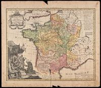
France Benedictine, ou carte generale des abbayes, & prieurez conventuels de l'Ordre de S. Benoit, tant d'hommes, que de filles, au jour a Norimberg, a 1738
Description:
Bottom left shows St. Maurice offering a book of prayers to Theodebert I, King of France who answers: "Plura Maurus precibus quam Nos Armis.", Imperfect: torn along bottom fold, with no loss of text. Watermark. Manuscript number in right corner: 19. From the Karpinski-von Wieser Map Collection., Includes note and legend., and Relief shown pictorially.
Publisher:
Recude[n]tibus Homan[n]ian. Heredib
Subject (Geographic):
France--Maps--Early works to 1800.
Subject (Name):
Homann Erben (Firm)
Subject (Topic):
Benedictine monasteries--France--Maps--Early works to 1800., Benedictine nuns--France--Maps--Early works to 1800., Convents, and Convents--France--Maps--Early works to 1800.
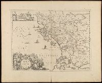
Appeared in Alexis Hubert Jaillot's Atlas, Relief shown by hachures and pictorially., and Watermark.
Publisher:
Chez l'auteur, le Sr. Jaillot, Geographe ordinaire du Roy, avec Privilege de sa Majesté,
Subject (Geographic):
Charente-Maritime (France)--Administrative and political divisions--Maps--Early works to 1800. and Charente-Maritime (France)--Maps--Early works to 1800.
Subject (Name):
Haye, G. de la and Jaillot, Alexis Hubert, 1632?-1712. Atlas françois.
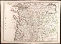
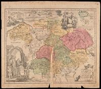
Imperfect: mutilated along fold, with some loss of text; chipped. Manuscript number in upper right corner: 4. From the Karpinski-von Wieser Map Collection., Includes illustration and inset: Appendix monasteriorum Ord. S. Bened. quae extant in Polonia et Lithuania., Relief shown pictorially., and Shows location of Benedictine monasteries in Holy Roman Empire, Poland, and Lithuania.
Publisher:
[Homann Erben]
Subject (Geographic):
Europe, Central and Germany
Subject (Topic):
Benedictine monasteries--Europe, Central--Maps--Early works to 1800, Benedictine monasteries--Germany--Maps--Early works to 1800, Monasteries--Europe, Central--Maps--Early works to 1800, and Monasteries--Germany--Maps--Early w
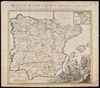
Illustrated cartouche., Includes inset: "America Benedictina"., Relief shown pictorially., and Watermark. Manuscript number "12" in upper right corner. From the Karpinski-von Wieser Map Collection.
Publisher:
Impensis Homannianorum Heredum
Subject (Geographic):
Europe--Iberian Peninsula, Iberian Peninsula--Maps--Early works to 1800., Portugal, Portugal--Maps--Early works to 1800., Spain, and Spain--Maps--Early works to 1800.
Subject (Name):
Benedictines, Benedictines--Iberian Peninsula--Maps--Early works to 1800, Benedictines--Portugal--Maps--Early works to 1800, Benedictines--Spain--Maps--Early works to 1800, Catholic C, and Catholic Church