
You Searched For
1 - 4 of 4
Search Results

2.
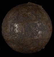
- Creator:
- Hill, Nathaniel, 1708-1768
- Published / Created:
- 1754.
- Call Number:
- Globe 45
- Image Count:
- 11
- Resource Type:
- cartographic three dimensional form
- Description:
- BEIN Globe 45: From the library of Stephen F. Gates. Accompanied by display plate., Terrestrial pocket globe showing the tracks of Anson's voyage, 1740-1744. Australia is drawn according to the Dutch discoveries and named New Holland., and Wooden spherical case in two parts covered with black sharkskin and lined with celestial maps of the northern and southern sky.
- Publisher:
- N. Hill?
- Subject (Name):
- Anson, George Anson, Baron, 1697-1762 and Anson, George Anson, Baron, 1697-1762.
- Subject (Topic):
- Travel and Maps
- Found in:
- Beinecke Rare Book and Manuscript Library > A new terrestrial globe [cartographic material]
3.
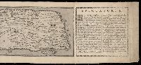
- Published / Created:
- MDXCVIII [1598]
- Call Number:
- 2016 +333
- Image Count:
- 13
- Resource Type:
- cartographic image
- Alternative Title:
- Peutinger table and Tabvla itineraria ex illvstri Pevtingerorvm Bibliotheca
- Description:
- BEIN 2016 +333: Imperfect: title panel mutilated, with some loss of text. Sheets joined together to form a roll; backed in linen., Relief shown pictorially., "MD" in publication date in apostrophic forms., Appears in Ortelius' Theatri Orbis Terrarum Parergon. Antwerp, 1624., and "Peutinger Table: Road map of Western Roman Empire about 250 A.D. bought by Conrad Peutinger and published in Venice by Aldus in 1591 (2 sections only), in Antwerp 1598 (12 sections) ... The only record of Roman map making that has survived to the present day."--Tooley's Dictionary of Mapmakers. New York, 1979.
- Publisher:
- È typographeio nostro [i.e. that of Jan Moretus]
- Subject (Geographic):
- Rome
- Subject (Topic):
- Roads, Geography, Ancient, and Maps
- Found in:
- Beinecke Rare Book and Manuscript Library > Tabula itineraria ex illustri Peutingerorum Bibliotheca quae Augustae Vindel est beneficio Marci Velseri Septemuiri Augustani in lucem edita. Nobilissimo viro Marco Velsero r.p. Augustanae Septemuiro Ioannes Moretus typographus Antverp s.p.d. ... [cartographic material].
4.
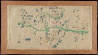
- Published / Created:
- [not after 1624]
- Call Number:
- Lanman 5626 1624
- Image Count:
- 1
- Resource Type:
- cartographic image
- Alternative Title:
- Map of Yuanzhou Fu, Jiangxi Province : prefecture and 3 counties
- Description:
- Title supplied by cataloger., Mounted on dull gold damask., and Covers three counties: Yichun Xian, Wanzai Xian, Fenyi Xian.
- Publisher:
- publisher not identified
- Subject (Geographic):
- Yichun (Jiangxi Sheng, China), Wanzai Xian (China), and Fenyi Xian (China)
- Subject (Topic):
- Maps
- Found in:
- Beinecke Rare Book and Manuscript Library > [Jiangxi Yuanzhou Fu tu]., [江西袁州府圖].