Skip to search
Skip to main content
Skip to first result
Search
You Searched For
Date
-
Genre
Engravings
Genre
Maps
Language
Latin
New Search
Search Results
Call Number:
Taylor 192 13
Collection Title:
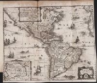
Decima tertia pars historiae Americanae, qvae continet exactam et accvratam descriptionem I. Novae
Image Count:
1
Subject (Geographic):
America --Description and travel and America --History --To 1810
Subject (Name):
Merian, Matthaeus, 1593-1650
Collection Created:
Francofvrti ad Moenum, Sumptibus M. Meriani,
Found in:
Beinecke Rare Book and Manuscript Library > American nouiter delineata
Creator:
Published / Created:
[ca. 1710]
Call Number:
1983 Folio 23
Collection Title:
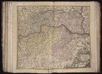
[Atlas factice of 50 maps, primarily by Johann Baptist Homann and/or issued by the Homann Erben
Image Count:
1
Alternative Title:
Basse Autriche qui se divise en 4. quartieres and Basse Avtriche qui se divise en 4. quartieres
Publisher:
[Johann Baptist Homann]
Subject (Geographic):
Austria --Maps --Early works to 1800
Collection Created:
[Nuremberg : Homann Erben, 1710-1786]
Found in:
Beinecke Rare Book and Manuscript Library > Archiducatus Austriae [cartographic material] : inferioris in omnes suas quadrantes ditiones divisi nova et exacta tabula / e conatibus Io. Baptistae Homanni
Creator:
Published / Created:
[ca. 1710]
Call Number:
1983 Folio 23
Collection Title:
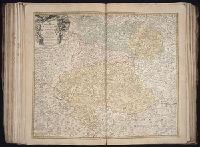
[Atlas factice of 50 maps, primarily by Johann Baptist Homann and/or issued by the Homann Erben
Image Count:
1
Alternative Title:
Haute Autriche qui se divise en 4 quartieres and Havte Avtriche qui se divise en 4 quartieres
Publisher:
[Johann Baptist Homann]
Subject (Geographic):
Austria --Maps --Early works to 1800
Collection Created:
[Nuremberg : Homann Erben, 1710-1786]
Found in:
Beinecke Rare Book and Manuscript Library > Archiducatus Austriae superioris in suas quadrantes ditiones exacte divisi accuratissima tabula [cartographic material] / ex amplissima Rev. Dn. Georg Matth. Vischer Sac. Caes. Mai. (Leopoldi Glor.mae Mem.) Geogra. ; desumta et exhibita a Ioh. Baptista Ho
Creator:
Published / Created:
1744
Call Number:
1973 Folio 30
Collection Title:
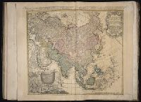
[Atlas factice of 32 maps and 1 distance table, produced by the Homann Erben firm]
Image Count:
2
Alternative Title:
Carte de l’Asie, projettee stereographiquement, tiree des relations et observations
Publisher:
Impensis Homannianorum Heredum
Subject (Geographic):
Asia --Maps --Early works to 1800
Subject (Topic):
Atlases, German --Early works to 1800
Collection Created:
[Nuremberg : s.n.,
Found in:
Beinecke Rare Book and Manuscript Library > Asia secundum legitimas projectionis stereographicae regulas et juxta recentissimas observation [cartographic material] : et relationes explosis aliorum fabulosis designationibus et narrationibus, adhibitis quoque veterum monumentis et recentiorum itinera
Creator:
Published / Created:
1744
Call Number:
1983 Folio 23
Collection Title:
[Atlas factice of 50 maps, primarily by Johann Baptist Homann and/or issued by the Homann Erben
Image Count:
1
Alternative Title:
Asia secundum legitimas projectionis stereographicae regulas et juxta recentissimas observationes and Carte de l’Asie, projettee stereographiquement, tiree des relations et observations
Publisher:
Impensis Homannianorum Heredum
Subject (Geographic):
Asia --Maps --Early works to 1800
Collection Created:
[Nuremberg : Homann Erben, 1710-1786]
Found in:
Beinecke Rare Book and Manuscript Library > Asia secundum legitimas projectionis stereographicae regulas et juxta recentissimas observationes [cartographic material] : et relationes explosis aliorum fabulosis designationibus et narrationibus, adhibitis quoque veterum monumentis et recentiorum itine
Creator:
Published / Created:
1744
Call Number:
1975 Folio 31
Collection Title:
[Atlas factice of 42 maps, produced by the Homann Erben firm]
Image Count:
1
Alternative Title:
Asia secundum legitimas projectionis stereographicae regulas et juxta recentissimas observationes and Carte de l’Asie, projettee stereographiquement, tiree des relations et observations
Publisher:
Impensis Homannianorum Heredum
Subject (Geographic):
Asia --Maps --Early works to 1800
Subject (Topic):
Atlases, German --Early works to 1800
Collection Created:
[Nuremberg,
Found in:
Beinecke Rare Book and Manuscript Library > Asia secundvm legitimas projectionis stereographicae regvlas et jvxta recentissimas observationes [cartographic material] : et relationes explosis aliorum fabulosis designationibus et narrationibus, adhibitis quoque veterum monumentis et recentiorum itine
Creator:
Published / Created:
anno 1653
Call Number:
1983 Folio 19
Collection Title:
[Atlas factice of 96 maps by Blaeu, Visscher, Jansson, Hondius and others]
Image Count:
2
Resource Type:
Maps, Atlases & Globes
Description:
All four sides of map decorated with city views and costumed figures of different social classes. Includes coats of arms., Imperfect: torn along fold, with some loss of text; portions of decorative border cut or torn and repaired, with missing sections replicated in ms.; tears repaired., and No. 5 of 92 maps bound together.
Publisher:
Excusum in aedibus auctoris
Subject (Geographic):
Asia --Maps --Early works to 1800
Subject (Topic):
Atlases --Early works to 1800
Collection Created:
[1556-1680]
Found in:
Beinecke Rare Book and Manuscript Library > Asiae nova descriptio / auctore Nicola. Io. Visscher
Creator:
Published / Created:
[ca. 1670]
Call Number:
1973 Folio 10
Image Count:
1
Resource Type:
Maps, Atlases & Globes
Description:
Ferro meridian., From Bleau's Atlas major (German ed.). Zu Amsterdam : Bey Johannem Blaeu, [ca. 1670]., No. 58 of 69 maps bound together in composite atlas., Relief shown pictorially., and Scale [ca. 1:4 000 000].
Publisher:
[Joan Blaeu]
Subject (Geographic):
Africa, North --Maps --Early works to 1800
Found in:
Beinecke Rare Book and Manuscript Library > Barbaria
Creator:
Published / Created:
[ca. 1710?]
Call Number:
1983 Folio 23
Collection Title:
[Atlas factice of 50 maps, primarily by Johann Baptist Homann and/or issued by the Homann Erben
Image Count:
1
Alternative Title:
Cercle de Baviere qui comprend la Regence d'Amberg, le Palatinat de Neuberg, et de Sulzbach, le Landgrafiat de Leichtenberg ...
Publisher:
[Johann Baptist Homann]
Subject (Geographic):
Bavaria (Germany) --Maps --Early works to 1800
Collection Created:
[Nuremberg : Homann Erben, 1710-1786]
Found in:
Beinecke Rare Book and Manuscript Library > Bavariae Circulus et Electorat in suas quas que ditiones tam cum adiacentibus quam insertis regionibus accuratissime divisus / [cartographic material] / per Io. Baptistam Homannum
Creator:
Published / Created:
1720?
Call Number:
1975 Folio 31
Collection Title:
[Atlas factice of 42 maps, produced by the Homann Erben firm]
Image Count:
1
Publisher:
Johann Baptist Homann
Subject (Geographic):
Netherlands --Maps --Early works to 1800 and New York (State) --Maps
Subject (Topic):
Atlases, German --Early works to 1800
Collection Created:
[Nuremberg,
Found in:
Beinecke Rare Book and Manuscript Library > Belgii pars septentrionalis communi nomine vulgo Hollandia nuncupata continens statum potentissimae Batavorum Reipublicea sev provincias VII foederatas / exhibente Io. Baptista Homanno
Branch:v1.61.8 ,Deployed:2024-06-20T11:14:55-04:00