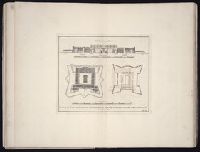
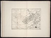
The West-India pilot: containing piloting directions for Port Royal and Kingston harbours in
Image Count:
1
Subject (Geographic):
Atlantic Ocean --Maps --Early works to 1800, Central America --Maps --Early works to 1800, and Honduras --Maps
Subject (Topic):
Harbors --Atlantic Coast (North America) --Maps --Early works to 1800, Nautical charts --Atlantic Coast (North America) --Early works to 1800, Nautical charts --Caribbean Area --Early works to 1800, Nautical charts --West Indies --Early works to 1800, Pilot guides --Atlantic Coast (North America) --Early works to 1800, Pilot guides --Caribbean Area --Early works to 1800, and Pilot guides --West Indies --Early works to 1800
Collection Created:
London : Printed for the author and sold by S. Hooper ..., MDCCLXXI [1771]
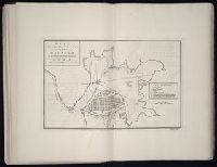
The West-India pilot: containing piloting directions for Port Royal and Kingston harbours in
Image Count:
1
Subject (Geographic):
Atlantic Ocean --Maps --Early works to 1800, Cuba --Maps --Early works to 1800, Havana (Cuba) --Maps --Early works to 1800, and West Indies --Maps --Early works to 1800
Subject (Topic):
Harbors --Atlantic Coast (North America) --Maps --Early works to 1800, Nautical charts --Atlantic Coast (North America) --Early works to 1800, Nautical charts --Caribbean Area --Early works to 1800, Nautical charts --West Indies --Early works to 1800, Pilot guides --Atlantic Coast (North America) --Early works to 1800, Pilot guides --Caribbean Area --Early works to 1800, and Pilot guides --West Indies --Early works to 1800
Collection Created:
London : Printed for the author and sold by S. Hooper ..., MDCCLXXI [1771]
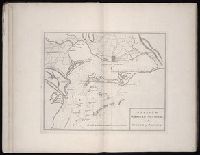
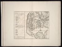
The West-India pilot: containing piloting directions for Port Royal and Kingston harbours in
Image Count:
1
Subject (Geographic):
Atlantic Ocean --Maps --Early works to 1800, Jamaica --Maps --Early works to 1800, and West Indies --Maps --Early works to 1800
Subject (Topic):
Harbors --Atlantic Coast (North America) --Maps --Early works to 1800, Nautical charts --Atlantic Coast (North America) --Early works to 1800, Nautical charts --Caribbean Area --Early works to 1800, Nautical charts --West Indies --Early works to 1800, Pilot guides --Atlantic Coast (North America) --Early works to 1800, Pilot guides --Caribbean Area --Early works to 1800, and Pilot guides --West Indies --Early works to 1800
Collection Created:
London : Printed for the author and sold by S. Hooper ..., MDCCLXXI [1771]
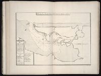
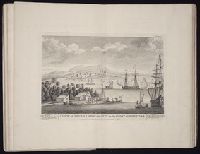
The West-India pilot: containing piloting directions for Port Royal and Kingston harbours in
Image Count:
1
Subject (Geographic):
Atlantic Ocean --Maps --Early works to 1800, Puerto Rico --Maps --Early works to 1800, and West Indies --Maps --Early works to 1800
Subject (Topic):
Harbors --Atlantic Coast (North America) --Maps --Early works to 1800, Nautical charts --Atlantic Coast (North America) --Early works to 1800, Nautical charts --Caribbean Area --Early works to 1800, Nautical charts --West Indies --Early works to 1800, Pilot guides --Atlantic Coast (North America) --Early works to 1800, Pilot guides --Caribbean Area --Early works to 1800, and Pilot guides --West Indies --Early works to 1800
Collection Created:
London : Printed for the author and sold by S. Hooper ..., MDCCLXXI [1771]
The West-India pilot: containing piloting directions for Port Royal and Kingston harbours in
Image Count:
1
Subject (Geographic):
Atlantic Ocean --Maps --Early works to 1800 and Panama --Maps --Early works to 1800
Subject (Topic):
Harbors --Atlantic Coast (North America) --Maps --Early works to 1800, Nautical charts --Atlantic Coast (North America) --Early works to 1800, Nautical charts --Caribbean Area --Early works to 1800, Nautical charts --West Indies --Early works to 1800, Pilot guides --Atlantic Coast (North America) --Early works to 1800, Pilot guides --Caribbean Area --Early works to 1800, and Pilot guides --West Indies --Early works to 1800
Collection Created:
London : Printed for the author and sold by S. Hooper ..., MDCCLXXI [1771]
The West-India pilot: containing piloting directions for Port Royal and Kingston harbours in
Image Count:
1
Subject (Geographic):
Atlantic Ocean --Maps --Early works to 1800 and Cartagena (Colombia) --Maps
Subject (Topic):
Harbors --Atlantic Coast (North America) --Maps --Early works to 1800, Nautical charts --Atlantic Coast (North America) --Early works to 1800, Nautical charts --Caribbean Area --Early works to 1800, Nautical charts --West Indies --Early works to 1800, Pilot guides --Atlantic Coast (North America) --Early works to 1800, Pilot guides --Caribbean Area --Early works to 1800, and Pilot guides --West Indies --Early works to 1800
Collection Created:
London : Printed for the author and sold by S. Hooper ..., MDCCLXXI [1771]
The West-India pilot: containing piloting directions for Port Royal and Kingston harbours in
Image Count:
1
Subject (Geographic):
Atlantic Ocean --Maps --Early works to 1800, Central America --Maps --Early works to 1800, and Honduras --Maps
Subject (Topic):
Harbors --Atlantic Coast (North America) --Maps --Early works to 1800, Nautical charts --Atlantic Coast (North America) --Early works to 1800, Nautical charts --Caribbean Area --Early works to 1800, Nautical charts --West Indies --Early works to 1800, Pilot guides --Atlantic Coast (North America) --Early works to 1800, Pilot guides --Caribbean Area --Early works to 1800, and Pilot guides --West Indies --Early works to 1800
Collection Created:
London : Printed for the author and sold by S. Hooper ..., MDCCLXXI [1771]