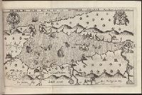
Bound in second after p. [48]., Depicts coat of arms of Henry IV of France and Mary I (Kingdom of Scotland)., Drawn by Marc Lescarbot, engraved by Jan Swelinck, published by I. Millot., Map has some small brown marks that can also be seen on the verso., Scale not given., and Teaching resource: Professor John Mack Faragher, History 141: The American West.
Subject (Geographic):
America --Discovery and exploration --French --Early works to 1800, New France --Discovery and exploration --Early works to 1800, and New France --Maps --Early works to 1800
Subject (Name):
Millot, Jean, b. 1582, printer, Swelinck, Jan, engraver, and Villegaignon, Nicolas Durand de, 1510-1571?
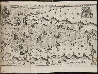
Bound in after p. 440., Depicts coat of arms of Henry IV of France and Mary I (Kingdom of Scotland)., Map has small brown mark on right-most edge that can also be seen on the verso., and Scale not given.
Subject (Geographic):
America --Discovery and exploration --French --Early works to 1800, New France --Discovery and exploration --Early works to 1800, and New France --Maps --Early works to 1800
Subject (Name):
Millot, Jean, b. 1582, printer, Swelinck, Jan, engraver
, and Villegaignon, Nicolas Durand de, 1510-1571?
Histoire de la Nouvelle-France : contenant les navigations, decouvertes, & habitations faites par
Image Count:
1
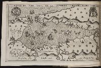
Description:
Bound in after p. 496., In pencil in upper left corner: 497., Map has three or four small brown marks on verso, the largest of which is on the right margin., and Scale not given.
Subject (Geographic):
America --Discovery and exploration --French --Early works to 1800, New France --Discovery and exploration --Early works to 1800, and New France --Maps --Early works to 1800
Subject (Name):
Millot, Jean, b. 1582, printer, Swelinck, Jan, engraver, and Villegaignon, Nicolas Durand de, 1510-1571?
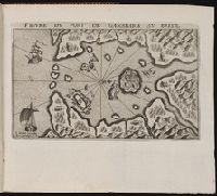
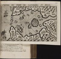
Bound in after p. 190., In pencil in lower left corner on recto: 190., In pencil in lower right corner on recto:262[?]., Map has approximately four small brown marks on the right-most portion that can also be seen on the verso., and Scale not given.
Subject (Geographic):
Guanabara Bay (Brazil) --Maps --Early works to 1800
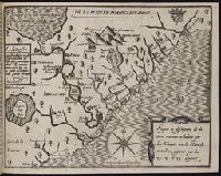
Bound in after p. 64., Depicts coat of arms of Henry IV of France., Map has two small brown marks on the upper left section that can also be seen on the verso., and Scale not given.
Subject (Geographic):
Acadia --Early works to 1800, America --Discovery and exploration --French --Early works to 1800, Florida --Maps --Early works to 1800, New France --Discovery and exploration --Early works to 1800, and New France --Maps --Early works to 1800
Title from item., Date from copy in Victoria & Albert Museum, accession number S.252-2018., Sheet trimmed., This electronic record is derived from historic data and may not reflect our current information. Review and updating of records is ongoing., and Temporary local Medical Library subject terms: Mountebanks.
Publisher:
chez Le Bas graveur du Roy, au bas de la rue de la Harpe vis à vis la rue Percée chez un Fayancier
Subject (Geographic):
Venice (Italy).
Subject (Topic):
Fairs, Quacks and quackery, Spectators, Puppet shows, Stages (Platforms)., Quacks & quackery, and Patent medicines
Bar scales given in mill. Germanica sive geometrica 15 in uno gradu and milliaria Gallica magna sive horae itineris., No. 14 of 69 maps bound together in composite atlas., Relief shown pictorially., and Scale [ca. 1:680 000].
BEIN PLAYING CARDS GEN 132: Title card pasted to sleeve. Formerly owned by Julia Parker Wightman. From the Cary Collection of Playing Cards. and Title card and 25 numbered cards depicting inhabitants of various countries.