[Atlas factice of 96 maps by Blaeu, Visscher, Jansson, Hondius and others]
Image Count:
2
Resource Type:
Maps, Atlases & Globes
Description:
All four sides of map decorated with city views and costumed figures of different social classes. Includes coats of arms., Imperfect: torn along fold, with some loss of text; portions of decorative border cut or torn and repaired, with missing sections replicated in ms.; tears repaired., and No. 5 of 92 maps bound together.
Ferro meridian., From Bleau's Atlas major (German ed.). Zu Amsterdam : Bey Johannem Blaeu, [ca. 1670]., No. 58 of 69 maps bound together in composite atlas., Relief shown pictorially., and Scale [ca. 1:4 000 000].
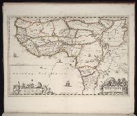
Bar scale given in milliaria Germanica communia., Covers west Africa from Tropic of Cancer southward., Ferro meridian., Map includes decorative title and scale statement cartouches with native figures and local fauna. Map interior displays three elephants., No. 59 of 69 maps bound together in composite atlas., Place names in Latin and Portuguese., Relief shown pictorially., and Scale [ca. 1:12 000 000].
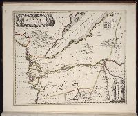
Bar scale given in milliaria Germanica., Ferro meridian., From Bleau's Atlas major (German ed.). Zu Amsterdam : Bey Johannem Blaeu, [ca. 1670]., No. 57 of 69 maps bound together in composite atlas., Oriented with north to the left., Relief shown pictorially., and Scale [ca 1:3 000 000].
Ferro meridian., Gemeene Duytsche mylen van 15 in een graedt., No. 53 of 69 maps bound together in composite atlas., Relief shown pictorially., and Scale [ca 1:8 750 000].
Publisher:
By Frederick de Wit in de Kalversbraet in de Witte Pascaert
Bar scales given in milliaria Germanica communia and milliaria Gallica communia., Ferro meridian., No. 54 of 69 maps bound together in composite atlas., Relief shown pictorially., and Scale [ca 1:1 330 000].