1. A Chart of the Internal Part of Louisiana, Including all the hitherto unexplored Countries, lying Creator: Pike, Zebulon Montgomery, 1779-1813 Published / Created: 1810 Call Number: GA405 +W44 (LC) Collection Title: Mapping the transmississippi West, 1540-1861 Image Count: 1 Found in: Beinecke Rare Book and Manuscript Library > A Chart of the Internal Part of Louisiana, Including all the hitherto unexplored Countries, lying between the River La Platte of the Missouri on the N: and the Red River on the S: the Mississippi East and the Mountains of Mexico West; with a Part of New M
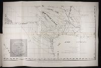
2. Section of Pichardo's map of New Mexico and adjacent regions, drawn in 1811 to assist in the Call Number: Zc20 931pi Collection Title: Pichardo’s treatise on the limits of Louisiana and Texas : an argumentative historical treatise Image Count: 1 Found in: Beinecke Rare Book and Manuscript Library > Section of Pichardo's map of New Mexico and adjacent regions, drawn in 1811 to assist in the determination of the boundaries between the Spanish dominions and the United States.