Search
You Searched For
Search Results
- Published / Created:
- Undated
- Call Number:
- Taylor 355
- Collection Title:
- America painted to the life. The true history of the Spaniards proceedings in the conquests of the
- Image Count:
- 1
- Subject (Geographic):
- North America --Maps --Early works to
- Found in:
- Beinecke Rare Book and Manuscript Library > Americae descrip
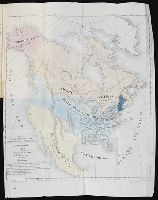
- Creator:
- Houbloup, L
- Published / Created:
- 1836
- Call Number:
- 1997 876
- Collection Title:
- De la democracia en la America del Norte / por Alejo de Tocqueville, abogado de la real audiencia
- Image Count:
- 1
- Resource Type:
- Books, Journals & Pamphlets
- Subject (Geographic):
- North America --Maps
- Found in:
- Beinecke Rare Book and Manuscript Library > Mapa para la obra intitulada De la Democracia en America por A. de Tocqueville
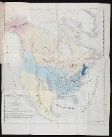
- Creator:
- Houbloup, L
- Published / Created:
- 1836
- Call Number:
- 1992 230
- Image Count:
- 1
- Resource Type:
- Books, Journals & Pamphlets
- Subject (Geographic):
- North America --Maps
- Found in:
- Beinecke Rare Book and Manuscript Library > Mapa para la obra intitulada De la Democracia en America por A. de Tocqueville
- Creator:
- Dunn, Samuel
- Published / Created:
- 1774
- Call Number:
- Cb23 27
- Collection Title:
- The American military pocket atlas : being an approved collection of correct maps, both general and
- Image Count:
- 1
- Subject (Geographic):
- North America --Maps --Early works to
- Found in:
- Beinecke Rare Book and Manuscript Library > North America as divided amongst the European powers
- Creator:
- Brasier, William
- Published / Created:
- 1776
- Call Number:
- Cb23 27
- Collection Title:
- The American military pocket atlas : being an approved collection of correct maps, both general and
- Image Count:
- 1
- Subject (Geographic):
- North America --Maps --Early works to
- Found in:
- Beinecke Rare Book and Manuscript Library > A Survey of Lake Champlain, including Lake George, Crown Point and St. John. Surveyed by order of His Excellency Major General Sr. Jeffery Amherst, knight of the most honble. Order of the Bath, Commander in Chief of His Majesty's forces in North America (now Lord Amherst) by William Brassier, draughtsman, 1762
- Creator:
- Erdoes, Richard, 1912-2008
- Published / Created:
- 1976-1983, undated
- Call Number:
- WA MSS S-2609
- Collection Title:
- Richard Erdoes papers
- Container / Volume:
- Box 46 | Plains Indian History II
- Image Count:
- 40
- Subject (Geographic):
- North America--Maps--Early works to
- Found in:
- Beinecke Rare Book and Manuscript Library > 18th Century Maps
- Published / Created:
- 1776
- Call Number:
- Cb23 27
- Collection Title:
- The American military pocket atlas : being an approved collection of correct maps, both general and
- Image Count:
- 1
- Subject (Geographic):
- North America --Maps --Early works to
- Found in:
- Beinecke Rare Book and Manuscript Library > A General map of the northern British colonies in America. which comprehends the province of Quebec, the government of Newfoundland, Nova-Scotia, New-England and New-York. From the maps published by the Admiralty and Board of Trade regulated by the astronomic and trigonometric observations of M. von Holland and corrected from Governor Pownall's late map 1776.
- Published / Created:
- 1776
- Call Number:
- Cb23 27
- Collection Title:
- The American military pocket atlas : being an approved collection of correct maps, both general and
- Image Count:
- 1
- Subject (Geographic):
- North America --Maps --Early works to
- Found in:
- Beinecke Rare Book and Manuscript Library > A general map of the middle British colonies in America. Containing Virginia, Maryland, the Delaware counties, Pennsylvania and New Jersey. With the addition of New York, and of the greatest part of New England, as also of the bordering parts of the province of Quebec, improved from several surveys made after the late war, and corrected from Governor Pownall's late map 1776.
- Creator:
- Romans, B
- Published / Created:
- 1776
- Call Number:
- Cb23 27
- Collection Title:
- The American military pocket atlas : being an approved collection of correct maps, both general and
- Image Count:
- 1
- Subject (Geographic):
- North America --Maps --Early works to
- Found in:
- Beinecke Rare Book and Manuscript Library > A General map of the southern British colonies, in America, comprehending North and South Carolina, Georgia, east and west Florida, with the neighbouring Indian countries. From the modern surveys of engineer de Brahm, Capt. Collet, Mouzon & others; and from the large hydrographical survey of the coasts of east and west Florida