Skip to search
Skip to main content
Skip to first result
Search
You Searched For
Genre
Manuscript maps
Genre
Maps
Resource Type
Maps, Atlases & Globes
New Search
Search Results
Published / Created:
1953?]
Call Number:
11hcf 1919A-4
Container / Volume:
BRBL_00010N
Image Count:
1
Resource Type:
Maps, Atlases & Globes
Description:
"CS- April 14, 1953.".
Publisher:
R.J. Kerner,
Subject (Geographic):
Poland--Maps
Found in:
Beinecke Rare Book and Manuscript Library > Small sketch map of Poland probably drawn by R.J. Kerner to illustrate hastily proposed Czech-Jugoslav Corridor.
Published / Created:
[1916?].
Call Number:
11hc 1916B
Container / Volume:
BRBL_00010C
Image Count:
2
Resource Type:
Maps, Atlases & Globes
Description:
Shows towns, roads, waterways, railways, and "limits of original German advance."
Publisher:
s.n.,
Subject (Geographic):
France--Maps
Found in:
Beinecke Rare Book and Manuscript Library > [Country between Paris and Strassbourg.]
Published / Created:
1919?]
Call Number:
11hcf 1919C-1-2
Container / Volume:
BRBL_00010S
Image Count:
1
Resource Type:
Maps, Atlases & Globes
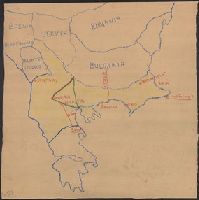
Description:
Map drawn in crayon. and Title supplied by cataloger.
Publisher:
s.n.,
Subject (Geographic):
Balkan Peninsula--Maps
Found in:
Beinecke Rare Book and Manuscript Library > [Manuscript Map of the Balkan Peninsula].
Published / Created:
1878?]
Call Number:
11hcf 1919C-1-1
Container / Volume:
BRBL_00010S
Image Count:
1
Resource Type:
Maps, Atlases & Globes
Description:
Legend indicates boundaries according to San Stefano in pink crayon, and boundaries according to Berlin in blue crayon. and Title supplied by cataloger.
Publisher:
s.n.,
Subject (Geographic):
Balkan Peninsula--Maps and Europe, Eastern--Maps
Subject (Topic):
Boundaries--Balkan Peninsula--Russo-Turkish War, 1877-1878 and Boundaries--Europe, Eastern--Russo-Turkish War, 1877-1878
Found in:
Beinecke Rare Book and Manuscript Library > [Manuscript Map showing boundaries according to the Treaty of Berlin and the Treaty of San Stefano].
Published / Created:
1919?]
Call Number:
11hcf 1919C-3-13
Container / Volume:
BRBL_00010U
Image Count:
1
Resource Type:
Maps, Atlases & Globes
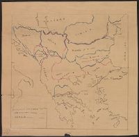
Description:
Politcal boundaries outlined and labeled in pink. and Title supplied by cataloger.
Publisher:
s.n.,
Subject (Geographic):
Balkan Peninsula--Maps and Europe, Eastern--Maps
Found in:
Beinecke Rare Book and Manuscript Library > [Manuscript map of Balkan Peninsula and Eastern Europe].
Published / Created:
1919?]
Call Number:
11hcf 1919C-3-15
Container / Volume:
BRBL_00010U
Image Count:
1
Resource Type:
Maps, Atlases & Globes
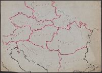
Description:
Area encompassing Bohemia, Moravia, Silesi, and Slovak districts outlined in yellow, green, and pink. and Title supplied by cataloger.
Publisher:
s.n.,
Subject (Geographic):
Balkan Peninsula--Maps and Europe, Eastern--Maps
Found in:
Beinecke Rare Book and Manuscript Library > [Manuscript map of Balkan Peninsula and Eastern Europe].
Published / Created:
1919?]
Call Number:
11hcf 1919C-1-3
Container / Volume:
BRBL_00010S
Image Count:
1
Resource Type:
Maps, Atlases & Globes
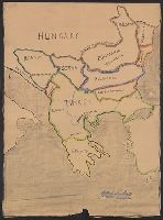
Description:
Map includes historical regions of Eastern Roumelia, Dobruja, and Bessarabia. Borders drawn in black ink, countries outlined in crayon. and Title supplied by cataloger.
Publisher:
s.n.,
Subject (Geographic):
Balkan Peninsula--Maps and Europe, Eastern--Maps
Subject (Topic):
Boundaries--Balkan Peninsula--Maps and Boundaries--Europe, Eastern--Maps
Found in:
Beinecke Rare Book and Manuscript Library > [Manuscript map of the Balkan Peninsula].
Published / Created:
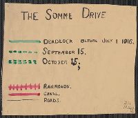
1916
Call Number:
11hc 1916
Container / Volume:
BRBL_00010C
Image Count:
1
Resource Type:
Maps, Atlases & Globes
Description:
Shows the location of battle lines dated "before July 1, 1916" and "September 15", "October 15", railways, canals, roads, wooded areas, and towns.
Publisher:
s.n.,
Subject (Geographic):
Somme (France)--Maps
Found in:
Beinecke Rare Book and Manuscript Library > [The Somme Drive.]
Branch:v1.61.6 ,Deployed:2024-06-12T09:55:31-04:00