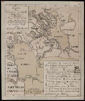
"Verstes russiennes dont une contient 500 toises de 7 pieds d'angleter"., Coordinates converted by cataloger to express longitude as measured from the Greenwich meridian., Includes map key of marble quarry locations, unidentified royal crown stamp, and shelf mark (K.3a)., and Relief shown by hachures.
Subject (Geographic):
Leningradskai︠a︡ oblastʹ (Russia)--Maps--Early works to 1800.
Subject (Topic):
Marble industry and trade--Russia (Federation)--Leningradskai︠a︡ oblastʹ--Maps--Early works to 1800.
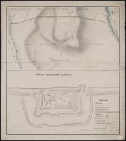
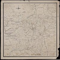
Карта большой Санктпетербургской дороге лежашей чрезъ Тверскую губернію / губернский землемеръ Андрей Петин.
Description:
Includes two insets, one showing the number of inhabitants in the 46 towns and villages along the road, the other the distances between various locations. and Mounted on silk. Manuscript annotation on map.
Subject (Geographic):
Tverskai︠a︡ oblastʹ (Russia)--Maps--Early works to 1800.
Detached from cloth backing; manuscript note on verso of cloth backing, "Copie de la nouvelle carte manuscrite du nouveau Mexique.", Relief shown pictorially., Unidentified stamp in title cartouche, "Bibliotheque de [?].", Watermark., and With manuscript note in French in plain red cartouche signed "Grandjean De Fouchy" noting the copy was made for Jean-Baptiste Chappe d'Auteroche.
Subject (Geographic):
Mexico--Maps--Early works to 1800. and Southwest, Old--Maps--Early works to 1800.
Subject (Name):
Chappe d'Auteroche, abbé, 1728-1769 and Fouchy, Jean Paul Grandjean de.
Color: pen and ink with green and blue shading., In the corner there is a table of the Florida and Cuban cays with their locations on the map. On the Island of Jamaica is marked Pta. Portland, presumably named after the Earl of Portland, councillor for trade and navigation, who died in 1663, or his son, who was killed fighting the Dutch in the battle off the Texel in 1665., On Jamaica the name "Kiniston" (Kingston) has been added early on, presumably about 1695, soon after its foundation, and in Hayti the name St. Luiz at a later period., and Spanish manuscript portolan chart on vellum. Unsigned and undated.
In manuscript on map: Kapitan" Matveĭ Loginov"; on verso: Ural-Gebiet, zwischen Kasan u. Jekaterinburg; stampf of the Königliches Kartographisches Institut, Berlin., Relief shown pictorially and by spot heights., and Title devised by cataloger.
Subject (Geographic):
Orenburgskai︠a︡ oblastʹ (Russia)--Maps--Early works to 1800. and Ural Mountains (Russia)--Maps--Early works to 1800.