Search
You Searched For
Search Results
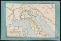
- Published / Created:
- 1714
- Call Number:
- 732 F963 1714
- Container / Volume:
- BRBL_00708
- Image Count:
- 1
- Resource Type:
- Maps, Atlases & Globes
- Found in:
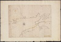
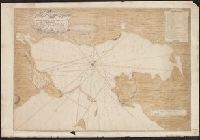
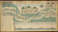
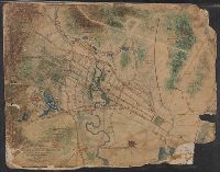
- Beinecke Rare Book and Manuscript Library > A Draft of the Bay of Fundy by John Wells.
- Published / Created:
- [1840?].
- Call Number:
- 764 B77 1740
- Container / Volume:
- BRBL_00710
- Image Count:
- 1
- Resource Type:
- Maps, Atlases & Globes
- Found in:
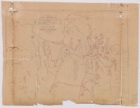
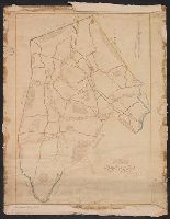
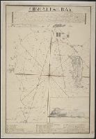
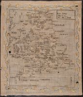
- Beinecke Rare Book and Manuscript Library > A Map of Brimfield as it was from its settlement 1720 till 1740. [Rev.] J[ason] Morse.
- Published / Created:
- 1774
- Call Number:
- 771 1774
- Container / Volume:
- BRBL_00713
- Image Count:
- 1
- Resource Type:
- Maps, Atlases & Globes
- Found in:
- Beinecke Rare Book and Manuscript Library > A Map of the Province of New York as divided into Counties together with the adjacent provinces. Compiled from the latest Maps and Actual Surveys. Will:Cockburn.
- Published / Created:
- 1828
- Call Number:
- 75 1828D
- Container / Volume:
- BRBL_00709
- Image Count:
- 1
- Resource Type:
- Maps, Atlases & Globes
- Found in:
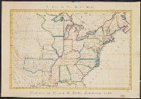
- Beinecke Rare Book and Manuscript Library > A Map of the United States. Projected by Nancy Gibbs, Livermore, 1828.
- Published / Created:
- [175-?]
- Call Number:
- 732 1750
- Container / Volume:
- BRBL_00708
- Image Count:
- 1
- Resource Type:
- Maps, Atlases & Globes
- Found in:
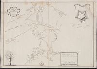
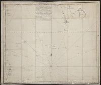
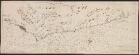
- Beinecke Rare Book and Manuscript Library > A Map of the surueyed parts of Noua Scotia.
- Published / Created:
- 1798
- Call Number:
- 27cea 1798
- Container / Volume:
- BRBL_00700
- Image Count:
- 1
- Resource Type:
- Maps, Atlases & Globes
- Found in:
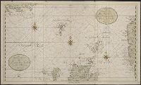
- Beinecke Rare Book and Manuscript Library > A New Chart of the Eastern Straits or the Straits of the East of Java, with a part of the Banda Sea; corrected and improved chiefly from the observation of Captn. - Williams.
- Published / Created:
- [ca. 1789]
- Call Number:
- 6555cea 1789
- Container / Volume:
- BRBL_00708
- Image Count:
- 3
- Resource Type:
- Maps, Atlases & Globes
- Found in:
- Beinecke Rare Book and Manuscript Library > A New Survey of that part of the Coast of Africa comprised between Cape Verga and Cape Formoso, including chiefly the Windward and Gold Coasts in which the Latitudes of all the Principal Places are determined by Actual observations, the bearings and cours
- Published / Created:
- 1711
- Call Number:
- 764 B65 1711
- Container / Volume:
- BRBL_00710
- Image Count:
- 1
- Resource Type:
- Maps, Atlases & Globes
- Found in:
- Beinecke Rare Book and Manuscript Library > A New plan of the Harbour of Boston in New England. Lat. 42, 29 North. Long. 71 West. Surveyed by Order of the Commissioners of her Majesty's Navy.
- Published / Created:
- 1821
- Call Number:
- 764 W688 1821
- Container / Volume:
- BRBL_00710
- Image Count:
- 1
- Resource Type:
- Maps, Atlases & Globes
- Found in:
- Beinecke Rare Book and Manuscript Library > A Plan of Wilmington Taken October 1821 by Edmund Parker.
- Published / Created:
- 1745
- Call Number:
- 7325cea L93 1745
- Container / Volume:
- BRBL_00709
- Image Count:
- 1
- Resource Type:
- Maps, Atlases & Globes
- Found in:
- Beinecke Rare Book and Manuscript Library > A Plan of the Harbour and Fortifications of Louisburg. The Harbour Survey'd by Capt. Phil: Durell. The fortifications by Capt. Will: Henry Bastide. Anne. 1745.
- Published / Created:
- 1758
- Call Number:
- 7325 L93 1758A
- Container / Volume:
- BRBL_00709
- Image Count:
- 1
- Resource Type:
- Maps, Atlases & Globes
- Found in:
- Beinecke Rare Book and Manuscript Library > A Plan of the Town and Harbour of Louisburg ... 1758. By Lieut. Joseph Norwood.
- Published / Created:
- [1780]
- Call Number:
- 29cea 1780
- Container / Volume:
- BRBL_00701
- Image Count:
- 1
- Resource Type:
- Maps, Atlases & Globes
- Found in:
- Beinecke Rare Book and Manuscript Library > A Plane Chart of several Islands Bank Shoals & Soundings ...
- Published / Created:
- [1750?]
- Call Number:
- 763fb Su87 1750
- Container / Volume:
- BRBL_00710
- Image Count:
- 1
- Resource Type:
- Maps, Atlases & Globes
- Found in:
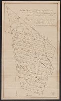
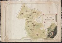
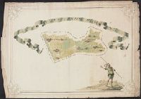
- Beinecke Rare Book and Manuscript Library > A Sketch of the Township of Sutton, lately Billymead, showing the number of the lot and to which propietor each lot is rett.
- Published / Created:
- 1785
- Call Number:
- 648cea Sa23 1785
- Container / Volume:
- BRBL_00708
- Image Count:
- 1
- Resource Type:
- Maps, Atlases & Globes
- Found in:
- Beinecke Rare Book and Manuscript Library > A chart of a bay [St. Francis Bay?] on the SE coast of Africa ... 1785 ... in Lat. 34°09'S, Long 26°10'E.
- Published / Created:
- [ca. 1758]
- Call Number:
- 732cea 1758
- Container / Volume:
- BRBL_00709
- Image Count:
- 1
- Resource Type:
- Maps, Atlases & Globes
- Found in:
- Beinecke Rare Book and Manuscript Library > A chart of the peninsula of Nova Scotia by Charles Morris.
- Published / Created:
- ca. 1705]
- Call Number:
- 732cea C413 1705
- Container / Volume:
- BRBL_00709
- Image Count:
- 1
- Resource Type:
- Maps, Atlases & Globes
- Found in:
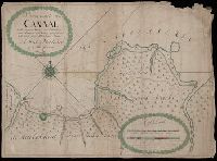
- Beinecke Rare Book and Manuscript Library > A draught of Southacks Bay in America [cartographic material].
- Published / Created:
- [1715?]
- Call Number:
- 53 1700
- Container / Volume:
- BRBL_00707
- Image Count:
- 1
- Resource Type:
- Maps, Atlases & Globes
- Found in:
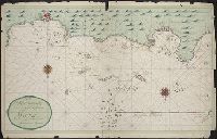
- Beinecke Rare Book and Manuscript Library > A large draught of the Red Sea from Mount Felix to Judda.
- Published / Created:
- April 1759.
- Call Number:
- 773 C884 1759
- Container / Volume:
- BRBL_00714
- Image Count:
- 1
- Resource Type:
- Maps, Atlases & Globes
- Found in:
- Beinecke Rare Book and Manuscript Library > A map of Isaac Cowgill's plantation : contain two hundred & seven acres and twenty perches / by Jno. Oliver.
- Published / Created:
- [1789]
- Call Number:
- BrSides 2017 121
- Image Count:
- 2
- Resource Type:
- Maps, Atlases & Globes
- Found in:
- Beinecke Rare Book and Manuscript Library > A map of lands purchased of the state of Georgia in 1789, by the South Carolina Yazou Company, by the Virginia Yazou Company, and by the Tennessee Company / sketched from a map of Zachariah Coxe's Esq., who made it from an actual survey of these counties; this draught, although coarsely done, is exact, and consonant the scale adopted by the said Coxe.
- Creator:
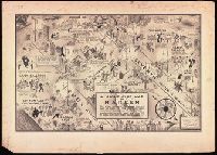
- Campbell, E. Simms (Elmer Simms), 1906-1971, creator
- Call Number:
- BrSides Double Folio 2016 34
- Image Count:
- 1
- Resource Type:
- cartographic image
- Found in:
- Beinecke Rare Book and Manuscript Library > A night-club map of Harlem : the stars indicate the places that are open all night, the only important omission is the location of the various speakeasies but since there are about 500 of them you won't have much trouble
- Published / Created:
- [ca. 1746]
- Call Number:
- 7325 L93 1746
- Container / Volume:
- BRBL_00709
- Image Count:
- 1
- Resource Type:
- Maps, Atlases & Globes
- Found in:
- Beinecke Rare Book and Manuscript Library > A plan of Louisbourg intended only to shew by strong red the publick buildings lately erected, and by faint red such as have had a thorough repair. I.H. Bastide.
- Published / Created:
- 1789
- Call Number:
- 761 St24 1789
- Container / Volume:
- BRBL_00710
- Image Count:
- 1
- Resource Type:
- Maps, Atlases & Globes
- Found in:
- Beinecke Rare Book and Manuscript Library > A plan of Pearsontonn [i.e. Standish Township] planned by ... Ephraim Jones Surveyor. Falmonth, Sept. 26, 1775. Copied August 28th, 1789 (by) Saml. Freeman.
- Creator:
- Morris, Charles, fl. 1749, cartographer
- Published / Created:
- 1751
- Call Number:
- 732 H13 1751
- Container / Volume:
- BRBL_00708
- Image Count:
- 1
- Resource Type:
- Maps, Atlases & Globes
- Found in:
- Beinecke Rare Book and Manuscript Library > A plan of the harbour of Halifax / by Charles Morris, chf. surveyr.
- Published / Created:
- 1747
- Call Number:
- 764 W52 1747
- Container / Volume:
- BRBL_00710
- Image Count:
- 1
- Resource Type:
- Maps, Atlases & Globes
- Found in:
- Beinecke Rare Book and Manuscript Library > An exact plan of Westborough South Precinct ... protracted and laid down by a scale of 200 perch for an inch by Hesebiah Ward, Surveyor.
- Creator:
- Lehman, Christian, creator
- Published / Created:
- [1857]
- Call Number:
- 2018 Folio 173
- Image Count:
- 93
- Resource Type:
- cartographic image
- Found in:
- Beinecke Rare Book and Manuscript Library > An explanation of the original location and general plan or draught of the lands and lots of Germantown and Creesam Townships, copied from Matthias Zimmerman's original dated June 26th A.D. 1746, and of the several districts and divisions thereof, part extracted from original and former draughts and part done and taken from actual mensuration drawn by Christian Lehman, July 28, 1776, recopied by his grandson Joseph Lehman, January 1, 1824, from which recopy this copy was taken, August 1857, for Peter E. Keyser
- Published / Created:
- 1757
- Call Number:
- 732 An73 1757
- Container / Volume:
- BRBL_00708
- Image Count:
- 1
- Resource Type:
- Maps, Atlases & Globes
- Found in:
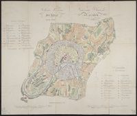
- Beinecke Rare Book and Manuscript Library > Annapolis-Royal with the adjacent country 1757.
- Published / Created:
- [1935?]
- Call Number:
- 766 B76 1935
- Container / Volume:
- BRBL_00711
- Image Count:
- 1
- Resource Type:
- Maps, Atlases & Globes
- Found in:
- Beinecke Rare Book and Manuscript Library > C.W.A. - F.E.R.A., Bridgeport Conn. Prepared from Official records. [Drawn by G.W. Carmalt].
- Published / Created:
- [1780?]
- Call Number:
- 40 P28 1780D
- Container / Volume:
- BRBL_00705
- Image Count:
- 1
- Resource Type:
- Maps, Atlases & Globes
- Found in:
- Beinecke Rare Book and Manuscript Library > Campagna Soprana Pavese Delegazione V.
- Published / Created:
- [1780?]
- Call Number:
- 40 P28 1780A
- Container / Volume:
- BRBL_00705
- Image Count:
- 1
- Resource Type:
- Maps, Atlases & Globes
- Found in:
- Beinecke Rare Book and Manuscript Library > Campagna Sottana Pavese Delegazione VI.
- Published / Created:
- [between 1840 and 1849?]
- Call Number:
- BrSides Double Folio 2018 104
- Image Count:
- 1
- Resource Type:
- Maps, Atlases & Globes
- Found in:
- Beinecke Rare Book and Manuscript Library > Carta geographia della provincia di Milano.
- Published / Created:
- 1675
- Call Number:
- 38hc 1675
- Container / Volume:
- BRBL_00172
- Image Count:
- 1
- Resource Type:
- Maps, Atlases & Globes
- Found in:
- Beinecke Rare Book and Manuscript Library > Carte ... du cours du Rhin depuis Basle jusqu'á Mayence dans laquelle sont compris ... sur laquelle on a tracé les mouvements et les positions des armées ... de 1674 et 1675. Par le Cher. de Beaurain.
- Published / Created:
- [1768?]
- Call Number:
- BrSides 2019 58
- Image Count:
- 1
- Resource Type:
- Maps, Atlases & Globes
- Found in:
- Beinecke Rare Book and Manuscript Library > Carte des carrieres de marbre decouvertes en Russie dans l'année 1768 sous la direction de S.E. Mr. le Lieut. General Comté de Bruce par le Conseiller d'État Koschin.
- Published / Created:
- 1832
- Call Number:
- 462 1832
- Container / Volume:
- BRBL_00706
- Image Count:
- 2
- Resource Type:
- Maps, Atlases & Globes
- Found in:
- Beinecke Rare Book and Manuscript Library > Carte du pays de Montenegro dressé par Mr. Tverdiglebov l'Mayor au service de Russie en 1832.
- Call Number:
- BrSides Folio 2019 53
- Image Count:
- 1
- Resource Type:
- Maps, Atlases & Globes
- Found in:
- Beinecke Rare Book and Manuscript Library > Charte der Krieges operation am Donn und Dniper ihro Russisch Kayserl. Maist. glorieusen Armeen, 1736.
- Published / Created:
- [between 1750 and 1800?]
- Call Number:
- BrSides Double Folio 2019 78
- Image Count:
- 1
- Resource Type:
- Maps, Atlases & Globes
- Found in:
- Beinecke Rare Book and Manuscript Library > Chertezhʺ Perekopskoĭ liniĭ.
- Published / Created:
- [1681?]
- Call Number:
- BrSides Folio 2019 60
- Image Count:
- 1
- Resource Type:
- Maps, Atlases & Globes
- Found in:
- Beinecke Rare Book and Manuscript Library > Chertezʺ ukrainskim i cherkaskimʺ gorodamʺ ot Moskvy do Kieva, i vʺ krymskui︠u︡ zemlu, dorogi bolshie, krasnye, chernie, malshie.
- Published / Created:
- 1595
- Call Number:
- 434 K83 1595
- Container / Volume:
- BRBL_00706
- Image Count:
- 1
- Resource Type:
- Maps, Atlases & Globes
- Found in:
- Beinecke Rare Book and Manuscript Library > Comorra [Komarno, Czechoslovakia]. Communicavit G. Houf [nagel].
- Creator:
- Freducci, Conte di Ottomano, active 1497-1539, cartographer
- Published / Created:
- [1536?]
- Call Number:
- Covers 49 +1536
- Image Count:
- 6
- Resource Type:
- cartographic image
- Found in:
- Beinecke Rare Book and Manuscript Library > Composite atlas of portolan charts produced by Conte di Ottomano Freducci
- Creator:
- Russell, Andrew, Cartographer
- Published / Created:
- 1861
- Call Number:
- BrSides Folio 2018 140
- Image Count:
- 1
- Resource Type:
- Maps, Atlases & Globes
- Found in:
- Beinecke Rare Book and Manuscript Library > Copy of part of P.L.S. Salter's plan shewing mineral locations at and near Mamainse with a projection shewing Montreal Mining Company's location / Andrew Russell, Assistant Commissioner.
- Published / Created:
- 1859
- Call Number:
- WA MSS S-1293
- Collection Title:
- Joseph Smith Harris papers
- Container / Volume:
- Box 2
- Image Count:
- 1
- Found in:
- Beinecke Rare Book and Manuscript Library > Correspondence
- Published / Created:
- [1780?]
- Call Number:
- 40 P28 1780B
- Container / Volume:
- BRBL_00705
- Image Count:
- 1
- Resource Type:
- Maps, Atlases & Globes
- Found in:
- Beinecke Rare Book and Manuscript Library > Del e Gazione Prima del Principato di Pavia.
- Published / Created:
- [1780?]
- Call Number:
- 40 C862 1780
- Container / Volume:
- BRBL_00705
- Image Count:
- 1
- Resource Type:
- Maps, Atlases & Globes
- Found in:
- Beinecke Rare Book and Manuscript Library > Descrittíone del Territorio Cremasco con Confíní.
- Published / Created:
- [1720]
- Call Number:
- 3748 1720
- Container / Volume:
- BRBL_00703
- Image Count:
- 1
- Resource Type:
- Maps, Atlases & Globes
- Found in:
- Beinecke Rare Book and Manuscript Library > Die Orthographische und Ichnographische Vorstellung der neüen Landstrassen so durch die Solloturnerische Landschafft, vom Schloss Falckenstein durch das Thal biss an Mimlisweil ... [Soloturn to Basel].
- Published / Created:
- [between 1840 and 1849?]
- Call Number:
- BrSides Elephant Folio 2018 33
- Image Count:
- 1
- Resource Type:
- Maps, Atlases & Globes
- Found in:
- Beinecke Rare Book and Manuscript Library > Dipartimento del Passariano.
- Published / Created:
- [1780?]
- Call Number:
- 40 N36 1780
- Container / Volume:
- BRBL_00705
- Image Count:
- 1
- Resource Type:
- Maps, Atlases & Globes
- Found in:
- Beinecke Rare Book and Manuscript Library > Dipartimento del Serio. Tipografico del Distretto della Nesa.
- Published / Created:
- [1790?]
- Call Number:
- 426 1790
- Container / Volume:
- BRBL_00706
- Image Count:
- 1
- Resource Type:
- Maps, Atlases & Globes
- Found in:
- Beinecke Rare Book and Manuscript Library > Ducato di Stiria.
- Published / Created:
- [ca. 1776]
- Call Number:
- 771hc 1776A
- Container / Volume:
- BRBL_00714
- Image Count:
- 1
- Resource Type:
- Maps, Atlases & Globes
- Found in:
- Beinecke Rare Book and Manuscript Library > Emplacement des Trouppes en Quartier d'hyver Sur Yorck-Long & Staten Island.
- Published / Created:
- [1886]
- Call Number:
- 60 1886
- Container / Volume:
- BRBL_00707
- Image Count:
- 2
- Resource Type:
- Maps, Atlases & Globes
- Found in:
- Beinecke Rare Book and Manuscript Library > Equatorial Africa.
- Published / Created:
- [1810?]
- Call Number:
- BrSides Double Folio 2018 105
- Image Count:
- 1
- Resource Type:
- Maps, Atlases & Globes
- Found in:
- Beinecke Rare Book and Manuscript Library > Estratto della mappa di nuovo censo del comune di Dresano mandamento di Paullo provincia di Milano.
- Published / Created:
- [1780]
- Call Number:
- 399 1780
- Container / Volume:
- BRBL_00704
- Image Count:
- 2
- Resource Type:
- Maps, Atlases & Globes
- Found in:
- Beinecke Rare Book and Manuscript Library > Estrecho de Gibraltar.
- Creator:
- Kirkwood, James Pugh, 1807-1877
- Published / Created:
- [1847]
- Call Number:
- 766 N46 1847A
- Container / Volume:
- BRBL_00712
- Image Count:
- 2
- Resource Type:
- Maps, Atlases & Globes
- Found in:
- Beinecke Rare Book and Manuscript Library > Experimental survey for a railroad between New Haven & Humphreysville, forming part of the line to Waterbury / made in July 1847 by J.P. Kirkwood.
- Published / Created:
- [1780?]
- Call Number:
- BrSides Elephant Folio 2019 5
- Image Count:
- 1
- Resource Type:
- Maps, Atlases & Globes
- Found in:
- Beinecke Rare Book and Manuscript Library > Generalʹnoĭ planʺ Borovit︠s︡kimʺ porogamʺ otʺ Opechenskoĭ do Poterpelʹskoĭ pristani ...
- Published / Created:
- [1800?]
- Call Number:
- 399 1800
- Container / Volume:
- BRBL_00704
- Image Count:
- 1
- Resource Type:
- Maps, Atlases & Globes
- Found in:
- Beinecke Rare Book and Manuscript Library > Gibraltar Bay.
- Published / Created:
- [1780?]
- Call Number:
- 399 1780A
- Container / Volume:
- BRBL_00704
- Image Count:
- 1
- Resource Type:
- Maps, Atlases & Globes
- Found in:
- Beinecke Rare Book and Manuscript Library > Gibraltar.
- Published / Created:
- [ca. 1725]
- Call Number:
- 6555cea 1725
- Container / Volume:
- BRBL_00708
- Image Count:
- 1
- Resource Type:
- Maps, Atlases & Globes
- Found in:
- Beinecke Rare Book and Manuscript Library > Goud Kust.
- Published / Created:
- 1726
- Call Number:
- 303cea 1726
- Container / Volume:
- BRBL_00701
- Image Count:
- 1
- Resource Type:
- Maps, Atlases & Globes
- Found in:
- Beinecke Rare Book and Manuscript Library > Het Nooderdeel van De Noord Zee seer Dienstig voor de Oost Indische Knuysors.
- Published / Created:
- 1597
- Call Number:
- 43 G99 1597
- Container / Volume:
- BRBL_00706
- Image Count:
- 1
- Resource Type:
- Maps, Atlases & Globes
- Found in:
- Beinecke Rare Book and Manuscript Library > Iaverinum, vulgo Rab [Gyor, Hungary] Iaverinum olim anno MDLXVI à Nicolao Aginelli Italo acuratissime delineatum ex manisculo in minorem tabullam traductum Amicis Agrippensibus id requiventib. amice communicat Georius Houfnaglius MDXCVII.
- Creator:
- Furgerson, Samuel
- Published / Created:
- 1809-1811
- Call Number:
- WA MSS 207
- Image Count:
- 104
- Resource Type:
- Archives or Manuscripts
- Found in:
- Beinecke Rare Book and Manuscript Library > Journal of a voyage from Boston to the North-West Coast of America
- Published / Created:
- 1774
- Call Number:
- 3331gmg H876 1774
- Container / Volume:
- BRBL_00701
- Image Count:
- 1
- Resource Type:
- Maps, Atlases & Globes
- Found in:
- Beinecke Rare Book and Manuscript Library > Kaart van den tegenwoordigen Zee-Dyk liggende voor de Landen van Muisduinen en de Helder, strekkende van het Nieuwe-Diep tot aan Kykduin, mitsgaders de diepte voor dezelve gepeild, van twee tot twee Roeden naar Zee, met Hoog-Water in Amsterd. Voeten door
- Published / Created:
- 1779
- Call Number:
- 3331gmg H788 1749
- Container / Volume:
- BRBL_00701
- Image Count:
- 1
- Resource Type:
- Maps, Atlases & Globes
- Found in:
- Beinecke Rare Book and Manuscript Library > Kaarte van de lengte en breete der Zand - Plaat genaamd De Horst ...
- Call Number:
- BrSides Folio 2019 56
- Image Count:
- 1
- Resource Type:
- Maps, Atlases & Globes
- Found in:
- Beinecke Rare Book and Manuscript Library > Karta : opisi i promeru glubiny, chasti dnieprovskago Limana i reki Buga do Nikolaeva / sochinena flota gospodinom kapitanʺ leĭtnantomʺ Aleksandrom Savit︠s︡kimʺ 1793 goda.
- Creator:
- Petin, Andreĭ
Петин, Андрей
- Published / Created:
- [between 1762 and 1796]
- Call Number:
- BrSides Double Folio 2019 77
- Image Count:
- 1
- Resource Type:
- Maps, Atlases & Globes
- Found in:
- Beinecke Rare Book and Manuscript Library > Karta bolʹshoĭ Sanktpeterburgskoĭ doroge lezhasheĭ chrezʺ Tverskui︠u︡ gubernīi︠u︡ / gubernskiĭ zemlemerʺ Andreĭ Petin.
- Creator:
- Bersenev, Ivan Mikhaĭlovich, -1789
Берсенев, Иван Михайлович, -1789
- Published / Created:
- [1785?]
- Call Number:
- BrSides Double Folio 2019 76
- Image Count:
- 1
- Resource Type:
- Maps, Atlases & Globes
- Found in:
- Beinecke Rare Book and Manuscript Library > Karta reki Dniepra ivsego Limana otʺ Khersona do mysa A., Kinburnskoi beregʺ / opisi flota kapitana vtorogo ranga Berseneva 1785 goda. Ochagovskoi beregʺ nalozhenʺ sprezhdnikhʺ kartʺ, glubina naznachena vʺ futakhʺ.
- Creator:
- Mellin, Ludwig August, Graf, 1754-1831
- Published / Created:
- Au mois de Dec. 1774.
- Call Number:
- BrSides Folio 2019 58
- Image Count:
- 1
- Resource Type:
- Maps, Atlases & Globes
- Found in:
- Beinecke Rare Book and Manuscript Library > Karte von der Merenge zwischen dem Schwarzen und Assowschen Meere, wie auch von dem Stücke der Krim so Russland gehoeret. Anno 1774 / L. A. Colo. Mellin, Lieutenant de L'Etat Major de l'armee, fec.
- Published / Created:
- 1612
- Call Number:
- 38 H453 1612
- Container / Volume:
- BRBL_00703
- Image Count:
- 1
- Resource Type:
- Maps, Atlases & Globes
- Found in:
- Beinecke Rare Book and Manuscript Library > La Ville de Hesdin.
- Published / Created:
- [1845?]
- Call Number:
- 40gcf 1845
- Container / Volume:
- BRBL_00705
- Image Count:
- 1
- Resource Type:
- Maps, Atlases & Globes
- Found in:
- Beinecke Rare Book and Manuscript Library > Linea di livellazione per il redefosso dal fundo del ponte al dazio di p. v. sino alla vecchiabbia di sotto de tre molini di S. Maria della Traversera.
- Published / Created:
- [between 1840 and 1849?]
- Call Number:
- BrSides 2018 158
- Image Count:
- 1
- Resource Type:
- Maps, Atlases & Globes
- Found in:
- Beinecke Rare Book and Manuscript Library > Lo e Alpi in Italia.
- Creator:
- Mitchell, Donald Grant, 1822-1908, cartographer
- Published / Created:
- [not before 1876]
- Call Number:
- Manuscript 766 N46 1870E
- Image Count:
- 1
- Resource Type:
- cartographic image
- Found in:
- Beinecke Rare Book and Manuscript Library > Manuscript map of New Haven Green to Edgewood by Donald G. Mitchell
- Published / Created:
- [1870?]
- Call Number:
- 766 N46 1870H
- Container / Volume:
- BRBL_00712
- Image Count:
- 4
- Resource Type:
- Maps, Atlases & Globes
- Found in:
- Beinecke Rare Book and Manuscript Library > Manuscript maps of New Haven.
- Creator:
- Conrad, Joseph, 1857-1924
- Published / Created:
- [1910?]
- Call Number:
- 652 1910
- Container / Volume:
- BRBL_00342
- Image Count:
- 1
- Resource Type:
- Maps, Atlases & Globes
- Found in:
- Beinecke Rare Book and Manuscript Library > Map of Congo Basin : showing path traveled by Joseph Conrad Korzeniowski.
- Creator:
- Giddings, Amelia
- Published / Created:
- 1815
- Call Number:
- BrSides Double Folio 2019 3
- Image Count:
- 2
- Resource Type:
- Maps, Atlases & Globes
- Found in:
- Beinecke Rare Book and Manuscript Library > Map of England / Amelia Giddings aged 9 years.
- Creator:
- Mitchell, Donald Grant, 1822-1908, cartographer
- Published / Created:
- [1870?]
- Call Number:
- Manuscript 766 N46 1870F
- Image Count:
- 1
- Resource Type:
- cartographic image
- Found in:
- Beinecke Rare Book and Manuscript Library > Map of Horse Railroad, Westville, & part of New Haven : enlarged four-fold from the county survey
- Published / Created:
- [1929?]
- Call Number:
- 632 K129 1929
- Container / Volume:
- BRBL_00708
- Image Count:
- 1
- Resource Type:
- Maps, Atlases & Globes
- Found in:
- Beinecke Rare Book and Manuscript Library > Map of Kampala showing collecting stations of water ...
- Creator:
- Denton, D. S., Jr., cartographer.
- Published / Created:
- [1907]
- Call Number:
- BrSides Double Folio 2018 88
- Image Count:
- 1
- Resource Type:
- Maps, Atlases & Globes
- Found in:
- Beinecke Rare Book and Manuscript Library > Map of Meadow Land at Ocean side in the town of Hempstead Nassau County, N.Y. belonging to the estate of Lewis Davison Dec'd and the estate of Tredwell Davison dec'd / surveyed in March 1907, by DS Denton, Jr.
- Published / Created:
- [1881?]
- Call Number:
- 766 N46 1724A
- Image Count:
- 1
- Resource Type:
- Maps, Atlases & Globes
- Found in:
- Beinecke Rare Book and Manuscript Library > Map of New Haven / drawn by Joseph Brown, 1724 ; copied by Prest. Ezra Stiles, 1782.
- Published / Created:
- [1881]
- Call Number:
- 766 N46 1724
- Container / Volume:
- BRBL_00712
- Image Count:
- 1
- Resource Type:
- Maps, Atlases & Globes
- Found in:
- Beinecke Rare Book and Manuscript Library > Map of New Haven / drawn by Joseph Brown, 1724 ; copied by Prest. Ezra Stiles, 1782.
- Published / Created:
- [ca. 1800]
- Call Number:
- 70 1800
- Container / Volume:
- BRBL_00708
- Image Count:
- 1
- Resource Type:
- Maps, Atlases & Globes
- Found in:
- Beinecke Rare Book and Manuscript Library > Map of North and South America; John Wood.
- Creator:
- Heyrick, J. C., creator
- Published / Created:
- 1912
- Call Number:
- 802gbc P429 1912
- Container / Volume:
- BRBL_00717
- Image Count:
- 1
- Resource Type:
- Maps, Atlases & Globes
- Found in:
- Beinecke Rare Book and Manuscript Library > Map of Riverside Coal & Timber Co. : lands on Little Leatherwood C'r, Perry Co., Kentucky / J.C. Heydrick.
- Creator:
- Mitchell, Donald Grant, 1822-1908, cartographer
- Published / Created:
- Decr. 1863.
- Call Number:
- Roll Map 78
- Image Count:
- 2
- Resource Type:
- cartographic image
- Found in:
- Beinecke Rare Book and Manuscript Library > Map of a portion of Westville & New Haven
- Published / Created:
- [1847]
- Call Number:
- 766 N46 1847
- Container / Volume:
- BRBL_00712
- Image Count:
- 1
- Resource Type:
- Maps, Atlases & Globes
- Found in:
- Beinecke Rare Book and Manuscript Library > Map of the city of New Haven.
- Creator:
- Heart, Jonathan, 1748-1791
- Published / Created:
- 1787
- Call Number:
- 774 F854 1787
- Container / Volume:
- BRBL_00730
- Image Count:
- 1
- Resource Type:
- Maps, Atlases & Globes
- Found in:
- Beinecke Rare Book and Manuscript Library > Map of the country adjacent to Fort [Franklin] on French Creek / by Jona. Heart ...
- Published / Created:
- [1791]
- Call Number:
- BrSides 2017 122
- Image Count:
- 2
- Resource Type:
- Maps, Atlases & Globes
- Found in:
- Beinecke Rare Book and Manuscript Library > Map of the western territory, 1791.
- Published / Created:
- [between 1850 and 1859?]
- Call Number:
- BrSides 2018 156
- Image Count:
- 1
- Resource Type:
- Maps, Atlases & Globes
- Found in:
- Beinecke Rare Book and Manuscript Library > Map showing copper lands in Virginia.
- Published / Created:
- 1783
- Call Number:
- 90 1783
- Container / Volume:
- BRBL_00721
- Image Count:
- 1
- Resource Type:
- Maps, Atlases & Globes
- Found in:
- Beinecke Rare Book and Manuscript Library > Mapa de una parte de la America Meridnl en que se manifiestan: los paises pertenecientes al Nuevo Reyno de Granada y Capitania General de Caracas de los dominios de neustro muy Augusto Soberano ... por ... don Francisco Requena ... 1783.
- Published / Created:
- 1788
- Call Number:
- 390 No. 9
- Container / Volume:
- BRBL_00703
- Image Count:
- 1
- Resource Type:
- Maps, Atlases & Globes
- Found in:
- Beinecke Rare Book and Manuscript Library > Mapa que comprehende la provincia antiqua de la Bética, dividida en quartro conventos jurídicos segun Plinio, y en el mismo número de gentes ó regiones segun Ptolemeo. Por D. Jaun Lopez.
- Creator:
- Johnson, Thomas H., Cartographer
- Published / Created:
- 2nd Feby. 1877.
- Call Number:
- BrSides Double Folio 2018 97
- Image Count:
- 1
- Resource Type:
- Maps, Atlases & Globes
- Found in:
- Beinecke Rare Book and Manuscript Library > McIntyre / Thos. H. Johnson, Assistant Commissioner.
- Call Number:
- BrSides Double Folio 2017 26
- Image Count:
- 1
- Resource Type:
- Maps, Atlases & Globes
- Found in:
- Beinecke Rare Book and Manuscript Library > New Haven in 1641.
- Published / Created:
- [1740?]
- Call Number:
- 275 1740
- Container / Volume:
- BRBL_00700
- Image Count:
- 1
- Resource Type:
- Maps, Atlases & Globes
- Found in:
- Beinecke Rare Book and Manuscript Library > Nieurve Afteekeningh Van de Noord Küst = Van Java. Vertoonende de Reede Van Batavia en Bantan.
- Creator:
- Maas, Abraham
- Published / Created:
- [1729]
- Call Number:
- BrSides Double Folio 2019 81
- Image Count:
- 1
- Resource Type:
- Maps, Atlases & Globes
- Found in:
- Beinecke Rare Book and Manuscript Library > Nieuwe kaarte van't canaal welke gegraven werd von Sleutelburg na nieu Ladoga / naukeurig opgesteld en getekend door Abraham Maas tot Sint Petersburg op d'oude Schans ter Ny 1729.
- Published / Created:
- 1827
- Call Number:
- 40 1840 (8) 618
- Container / Volume:
- BRBL_00200
- Image Count:
- 1
- Resource Type:
- Maps, Atlases & Globes
- Found in:
- Beinecke Rare Book and Manuscript Library > No. 1 [area around Marghera and Campalto, present day Mestre, near Venice, Italy] / firmato Castelli Capitano del Genio.
- Published / Created:
- 1827
- Call Number:
- 40 1840 (9) 617
- Container / Volume:
- BRBL_00200
- Image Count:
- 1
- Resource Type:
- Maps, Atlases & Globes
- Found in:
- Beinecke Rare Book and Manuscript Library > No. 2 [area around Forte di St. Nicolo del Lido and La Certosa, Venice, Italy] / firmato Castelli Capitano del Genio, firmato gezeichnet vom Jacob Horkij Cadet et Sappefürher.
- Published / Created:
- 1826
- Call Number:
- 352 M85 1826
- Container / Volume:
- BRBL_00702
- Image Count:
- 1
- Resource Type:
- Maps, Atlases & Globes
- Found in:
- Beinecke Rare Book and Manuscript Library > Nouveau Plan de Moscou. Dressé par la Commission des bâtiments pour servir au Guide du Voyageur G.L. de Laveau.
- Creator:
- Alzate y Ramírez, José Antonio de, 1737-1799
- Published / Created:
- An[n]o de 1768.
- Call Number:
- BrSides Elephant Folio 2018 13
- Image Count:
- 1
- Resource Type:
- Maps, Atlases & Globes
- Found in:
- Beinecke Rare Book and Manuscript Library > Nuevo mapa geographico de la America Septentrional : perteneciente alvirreynato de Mexico / dedicado a los sabios miembros de lá Academia Real de la Ciencias de Paris, por sumy rendido servidor y capellan Don Josef Antonio de Alzate y Ramirez.
- Published / Created:
- [1780?]
- Call Number:
- 40 P28 1780
- Container / Volume:
- BRBL_00705
- Image Count:
- 1
- Resource Type:
- Maps, Atlases & Globes
- Found in:
- Beinecke Rare Book and Manuscript Library > Parco Nuovo Pavese delegazione XIII.
- Published / Created:
- [1780?]
- Call Number:
- 40 P28 1780C
- Container / Volume:
- BRBL_00705
- Image Count:
- 1
- Resource Type:
- Maps, Atlases & Globes
- Found in:
- Beinecke Rare Book and Manuscript Library > Parco Vecchio Pavise Delegazione XII.
- Published / Created:
- 1738
- Call Number:
- 583 1738
- Container / Volume:
- BRBL_00707
- Image Count:
- 1
- Resource Type:
- Maps, Atlases & Globes
- Found in:
- Beinecke Rare Book and Manuscript Library > Part of Malaya. Part of Tanasary.
- Published / Created:
- 1717
- Call Number:
- 461 B41 1717
- Container / Volume:
- BRBL_00706
- Image Count:
- 1
- Resource Type:
- Maps, Atlases & Globes
- Found in:
- Beinecke Rare Book and Manuscript Library > Pianta ... gran piazza de Belgrado ...
- Published / Created:
- [1830?]
- Call Number:
- 40 M841 1830
- Container / Volume:
- BRBL_00705
- Image Count:
- 1
- Resource Type:
- Maps, Atlases & Globes
- Found in:
- Beinecke Rare Book and Manuscript Library > Pianta della Citta di Mortara.
- Published / Created:
- 1745
- Call Number:
- 36 P471 1745
- Container / Volume:
- BRBL_00702
- Image Count:
- 1
- Resource Type:
- Maps, Atlases & Globes
- Found in:
- Beinecke Rare Book and Manuscript Library > Plan de L'Attaque de Pfaffenhoffen. Faite par Mr. de Batiany ... 1745.
- Published / Created:
- 1721
- Call Number:
- 795 N47 1721
- Container / Volume:
- BRBL_00716
- Image Count:
- 1
- Resource Type:
- Maps, Atlases & Globes
- Found in:
- Beinecke Rare Book and Manuscript Library > Plan de la Nouvelle Orleans Scituée sur le Fleuve St. Louis ... 1721.