Skip to search
Skip to main content
Skip to first result
Yale University Library
Ask Yale Library
Reserve Rooms
Places to Study
Research
Quicksearch
Search Library Catalog (Orbis)
Search Law Library Catalog (MORRIS)
Search Borrow Direct
Search WorldCat
Search Articles+
Search Digital Collections
Search Archives at Yale
Research Guides
Find Databases by Title
Find eJournals by Title
Guide to Using Special Collections
Services
Your Personal Librarian
Subject Specialists
Research Support and Workshops
Citation Tools
OverDrive: Popular Audio and eBooks
Get It @ Yale (Borrow Direct, Interlibrary Loan, Scan & Deliver)
Course Reserves
Off-Campus Access
EliScholar
OverDrive: Popular Audio and eBooks
Bass Media Equipment
Libraries & Collections
Arts Library
Bass Library
Beinecke Library
Classics Library
Divinity Library
Film Study Center
Fortunoff Archive
Humanities Collections
International Collections
Law Library
Lewis Walpole Library
Library Collection Services
Manuscripts & Archives
Map Collection
Marx Science & Social Science Library
Medical Library
Music Library
Sterling Library
Yale Center for British Art
Information & Policies
Library Hours
Departments & Staff
Borrowing & Circulation
Services for Persons with Disabilities
Copyright Basics
Scanning, Printing & Copying
Computers & Wireless
Library Policies
About the Library
Giving to the Library
Purchase Request
Working at the Library
Terms Governing Use of Materials
Search in
All Fields
Creator
Title
Call Number
Date
Subject
Orbis ID
Full Text
Description
Full text
search for
Search
Search
Advanced Search
Digital Collections
Search
You Searched For
Genre
Maps
Genre
Prints (Visual works)
Resource Type
Maps, Atlases & Globes
New Search
« Previous
|
1
-
60
of
94
|
Next »
Sort
by Title (Z --> A)
relevance
Creator (A --> Z)
Creator (Z --> A)
Title (A --> Z)
Title (Z --> A)
Year (ascending)
Year (descending)
Number of results to display per page
60
per page
9
per page
30
per page
60
per page
99
per page
View results as:
List
List
Gallery
Gallery
Search Results
[Map of Alaska]
[Geographia. Italian]
[Geographia. Italian]
[Geographia. Italian]
[Geographia. Italian]
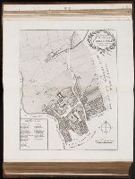
Walbrook Ward and Dow Gate Ward with its division into parishes taken from the last surveys
Vniversi orbis descriptop as vsvm navigantivm
Vniversi orbis descriptio ad vsvm navigantivm
Turks Islands, from a survey made in 1753, by the the sloops l'Aigle and l'Emeraude, by order of
The route of the Alaska excursion steamers
The phenomena of the universe ...
The parish of St. Johns Wapping
The parish of St. James Clerkenwell taken from [the] last survey with corrections
The island of Hispaniola called by the French St. Domingo. Subject to France and Spain. from the
The island of Hispaniola called by the French St. Domingo. Subject to France and Spain
The harbour of Bluefields.
The course of the great River Wolga
The Wards of Farington within and Baynards Castle with its divisions into parishes taken from the
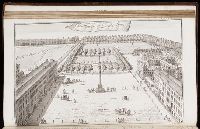
The Prospect of Lincoln's Inn
The Prospect of Grays Inn
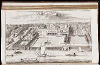
The Custom House
Tableau physique des Ils Canaries. Geographie des plantes du Pic de Teneriffe
Tableau physique de la pente Orientale du Plateau de la Nouvelle Espagne (Chemin de Mexico a
Tableau du Plateau central des Montagnes du Mexique, entre les 19 et 21 [degree] de Latitude
St. Olave and St. Mary Magdalen Bermondsey Southwark, taken from the last survey with corrections
Spittle Fields and places adjacent taken from the last survey with corrections
South part of St. Domingo, of Hispaniola, by Thos Jeffreys geographer to his Majesty
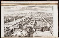
Somerset House
Shoreditch, Norton Folgate, and Crepple Gate without, taken from the last survey with corrections
Queen Hith Ward and Vintry Ward with their division into parishes taken from the last surveys
Profit du Chemin de Carthagene des Indes au Plateau de Santa Fe de Bogata. pl. 6
Profit du Canal de Huehuetoca (Desague Real.) Creuse pour preserver la Ville de Mexico du danger
Presidio de n.s. de Loreto en la Bahia
Portsoken ward being part of the parish of St. Buttolphs Aldgate, taken from the last survey, with
Plan of the city and harbour of Havanna. pl. 23
Plan of the cities of London and Westminster, the Borough of Southwark, and parts adjoining
Plan of New Orleans the capital of Louisiana; with the disposition of its quarters and canals as
Plan del Presidio dens de los Dolores
Part of Aldgate Ward
New-York
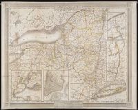
Map of the United Kingdom of Great Britain and Ireland
Madagascar
Limite inferieure des Neiges perpetuelles a differentes Latitudes
Les Etats de Savoye et de Piemont
Leogane and Port au Prince in the island of Hispaniola. pl. 33
Lengths of the principal rivers in the world
Jamaica from the latest surveys; improved and engraved by Thomas Jefferys geographer to the king
Fortification
Fortification
Farington Ward without, with its divisions into parishes, taken from the last survey with
Descrittione di tvtto'l mondo, secondo la prattica de Marinari. Vniversi orbis descriptio ad vsvm
Descrittione di tvtto'l mondo, secondo la prattica de Marinari. Vniversi orbis descriptio ad vsvm
Descrittione dell'isola Spagnuola prima iso la scoperta dal Colombo
Descrittione dell'isola Spagnuola
Descrittione dell'isola Spagnuola
Descrittione dell'isola Cuba, che dal Colombo fu scoperta insieme con la Spagnuloa
Descrittione dell'isola Cuba
Descrittione dell'America, odell'India Occidentale. America
Descrittione dell' isola Cuba
Des rivier legt op de Hoogte von 18 Graaden Zuyder Breedte aan het Land van de Megosie ter Kuste
PREVIOUS
«
1
2
»
NEXT
Limit your search
Extent of Digitization
Partially digitized
89
Unspecified
3
Completely digitized
2
Access
Public
93
Yale Community Only
1
Repository
Beinecke Rare Book and Manuscript Library
94
Format
cartographic
85
still image
5
mixed material
4
Genre
Maps
✖
[remove]
94
Prints (Visual works)
✖
[remove]
94
Engravings
75
Maps in books
45
Illustrations
36
Hand coloring
7
Etchings
4
Atlases
3
Lithographs
3
Planographic prints
3
more
Genre
»
Resource Type
Maps, Atlases & Globes
✖
[remove]
94
Language
English
8
Italian
2
Creator
Jefferys, Thomas, d. 1771
6
Clark, William, 1770-1838
3
Keulen, Gerard van
3
Keulen, Johannes van.
3
Marre, Jan de, 1696-1763.
3
Vooght, Claes Janszoon, d. 1696.
3
Fee, Chas E
2
Robert Sayer and John Bennett (Firm)
2
Wyld, James, 1812-1887
2
Bennett, John
1
more
Creator
»
Subject (Topic)
Geography--Early works to 1800
8
Nautical charts
8
Voyages and travels
8
Islands
6
Discoveries in geography
5
Explorers
5
Geography, Ancient
5
Scientific expeditions
5
Mountains
4
Discoveries in geography.
3
more
Subject (Topic)
»
Subject (Name)
P.S. Duval & Son
2
Hodgson, Ralph,--1871-1962--Autograph
1
Publication Place
Chicago
2
Berlin, Paris
1
Mexico, Berlin
1
New York
1
Paris
1
Philadelphia
1
Veracruz
1
[London]
1
[London] :
1
Date Created
View distribution
Current results range from
1691
to
1891
Date Created range begin
Date Created range end
View larger »
[Missing]
60