Skip to search
Skip to main content
Skip to first result
Search
You Searched For
"Michigan"
Repository
Beinecke Rare Book and Manuscript Library
Genre
Maps
Language
English
New Search
Search Results
Published / Created:
1858
Call Number:
811cea Sa245 1858
Container / Volume:
BRBL_00554
Image Count:
1
Resource Type:
Maps, Atlases & Globes
Alternative Title:
Channel cut of Middle Channel
Description:
"C.B. Graham, lithr."
Publisher:
s.n.] ,
Subject (Geographic):
Michigan --Maps
Subject (Name):
Graham, C. B. (Curtis B.)
Found in:
Beinecke Rare Book and Manuscript Library > Channel cut of Middle Channel, Lake George : St. Mary's River improvement showing character of bottom & extent of dredging up to September 30th 1858 / drawn by James T. Baker, surveyed under the orders of Capt. A.W. Whipple, T.E., by J.H. Forster U.S. Sub
Published / Created:
1858
Call Number:
811cea Sa245 1858A
Container / Volume:
BRBL_00554
Image Count:
1
Resource Type:
Maps, Atlases & Globes
Alternative Title:
Chart of East Neebish rapids
Description:
"Note: The remaining portions of this map are enlarged from a published chart of the U.S. Lake survey made in 1853."
Publisher:
J. Bien, lith.,
Subject (Geographic):
Michigan --Maps
Found in:
Beinecke Rare Book and Manuscript Library > Chart of East Neebish rapids, River St. Mary : showing the improved west channel, dredged and surveyed in 1858 under the direction of Capt. A.W. Whipple, T.E. / J.H. Foster U.S. Sub. Agt., James T. Foster, draughtsman.
Published / Created:
1858
Call Number:
811cea Sa245 1858B
Container / Volume:
BRBL_00554
Image Count:
1
Resource Type:
Maps, Atlases & Globes
Alternative Title:
Tracing of field chart of West Channel
Description:
"C.B. Graham, lithr."
Publisher:
s.n.] ,
Subject (Geographic):
Michigan --Maps
Subject (Name):
Graham, C. B. (Curtis B.)
Found in:
Beinecke Rare Book and Manuscript Library > Tracing of field chart of West Channel of East Neebish rapids : surveyed for the use of the St. Mary's River improvement under the orders of Capt. A.W. Whipple, T.E. / by J.H. Foster U.S. Sub. Agt. May 1858.
Published / Created:
[1859?] and [between 1880 and 1889?]
Call Number:
BrSides Folio 2018 138
Image Count:
1
Resource Type:
Maps, Atlases & Globes
Alternative Title:
Map of a portion of Point Keweenaw, Lake Superior
Description:
Backed with linen. Manuscript annotations on map. Manuscript title on verso: Copper Harbour & Eagle Harbour. From the Richard H. Rickard Papers. and In upper left corner: 59.
Publisher:
[publisher not identified],
Subject (Geographic):
Michigan --Keweenaw County
Subject (Name):
Delaware Mining Company of Michigan
Subject (Topic):
Copper mines and mining--Michigan
Found in:
Beinecke Rare Book and Manuscript Library > Map of a portion of Point Keweenaw, L.S. : showing the lands &c. of the Pennsylvania & Delaware Mining Co's.
Creator:
Published / Created:
[1839?]
Call Number:
811 1839A
Container / Volume:
BRBL_00552
Image Count:
4
Resource Type:
Maps, Atlases & Globes
Alternative Title:
Map of Michigan and part of Wisconsin
Description:
"Entered according to Act of Congress July 10, 1839 by David H. Burr in the clerk's office of the District Court of the District of Columbia." and Prime meridians: Greenwich and Washington.
Publisher:
J. Arrowsmith,
Subject (Geographic):
Michigan --Maps
Subject (Name):
Arrowsmith, John, 1790-1873
Found in:
Beinecke Rare Book and Manuscript Library > Map of Michigan & part of Wisconsin Territory : exhibiting the post offices, post roads, canals, rail roads, &c. / by David H. Burr.
Creator:
Published / Created:
[1859]
Call Number:
BrSides Folio 2018 137
Image Count:
1
Resource Type:
Maps, Atlases & Globes
Abstract:
Shows railroads, corporate land ownership, plats of Marquette and Negaunee, sawmill locations in all or parts of sections T.47-48 N, R. 25-27 W.
Description:
Backed with linen. Manuscript annotations on map. Manuscript title on verso: Marquette Iron Region. From the Richard H. Rickard Papers., Coordinates not present on map and are approximated., Detached from: A statement of the plan of the St. Mary's Canal Mineral Land Company (New York : Baker & Godwin, printers, 1859)., and Relief shown by hachures.
Publisher:
[Baker & Godwin, printers],
Subject (Geographic):
Michigan --Upper Peninsula
Subject (Name):
Collins Iron Company--Maps., Excelsior Iron Company--Maps., Jackson Iron Company (Fayette, Mich.)--Maps., Peninsula Iron Company--Maps., Pioneer Iron Company--Maps., and Rickard, Richard H.,---1885--Owner
Subject (Topic):
Iron mines and mining--Michigan --Upper
Found in:
Beinecke Rare Book and Manuscript Library > Map showing iron mines in vicinity of Marquette, Lake Superior [cartographic material].
Creator:
Published / Created:
1892?]
Call Number:
811 B44 1892
Container / Volume:
BRBL_00553
Image Count:
1
Resource Type:
Maps, Atlases & Globes
Description:
Includes text. and Shows land parcels, including those owned by Benton Harbor Improvement Association.
Publisher:
s.n.,
Subject (Geographic):
Benton Harbor (Mich.)--Maps
Subject (Topic):
Real property--Michigan --Benton Harbor
Found in:
Beinecke Rare Book and Manuscript Library > Benton Harbor : already a manufacturing, railroad and business center, is destined to speedily become one of the great cities of Michigan.
Creator:
Published / Created:
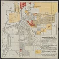
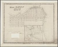
1857
Call Number:
811 M21 1857
Collection Title:
Exposition of the natural position of Mackinaw City.
Container / Volume:
BRBL_00553
Image Count:
1
Resource Type:
Maps, Atlases & Globes
Description:
Elevation shown by spot heights, bathymetry by soundings, in feet., Imperfect: Mutilated with loss of text., Inset: Straits of Mackinaw and vicinity., and Shows property boundaries and proposed railroads and docks.
Publisher:
Middleton, Wallace & Co., lithrs.
Subject (Geographic):
Mackinaw City (Mich.)--Maps
Subject (Name):
De La Vergne, Earl W. pro and Middleton, Wallace & Co
Subject (Topic):
Real property--Michigan --Mackinaw City
Found in:
Beinecke Rare Book and Manuscript Library > Mackinaw City : from actual survey made August 1857 / by R.C. Phillips, surveyor.
Published / Created:
1913
Call Number:
811 D48 1913
Container / Volume:
BRBL_00553
Image Count:
1
Resource Type:
Maps, Atlases & Globes
Alternative Title:
Map of the city of Detroit, Michigan
Description:
Imperfect. Mutilated with possible loss of text. and Includes street guide.
Publisher:
R.L. Polk & Co.,
Subject (Geographic):
Detroit (Michigan )--Maps
Found in:
Beinecke Rare Book and Manuscript Library > R.L. Polk & Co.'s map of the city of Detroit, Michigan.
Published / Created:
1913
Call Number:
811 D48 1913A
Container / Volume:
BRBL_00553
Image Count:
2
Resource Type:
Maps, Atlases & Globes
Description:
Includes street guide.
Publisher:
Silas Farmer & Co.,
Subject (Geographic):
Detroit (Michigan )--Maps
Found in:
Beinecke Rare Book and Manuscript Library > Ideal map of the city of Detroit Michigan.
Branch:v1.61.8 ,Deployed:2024-06-20T11:14:55-04:00