Skip to search
Skip to main content
Skip to first result
Search
You Searched For
"Michigan"
Repository
Beinecke Rare Book and Manuscript Library
Genre
Maps
Language
English
New Search
Search Results
Creator:
Published / Created:
[1843]
Call Number:
BrSides 2019 109
Image Count:
2
Resource Type:
Maps, Atlases & Globes
Description:
Michigan ; N. part of Maine; Plan of Washington
Publisher:
[Goodyear?],
Subject (Geographic):
United States--Maps.
Subject (Name):
Chickering, J. H.--Autograph.
Subject (Topic):
Counties--United States--Maps.
Found in:
Beinecke Rare Book and Manuscript Library > Goodyear's miniature county map of the United States / engraved by J.H. Goldthwait.
Published / Created:
1783
Call Number:
771 1783
Container / Volume:
BRBL_00477
Image Count:
2
Resource Type:
Maps, Atlases & Globes
Description:
, Maryland, Ohio and Michigan . The French Colony
Subject (Geographic):
New York--Maps, Manuscript--Early works to 1800
Found in:
Beinecke Rare Book and Manuscript Library > Map of the State of New York and Parts adjacent. Will Cockburn, 1780. With the improvements in the year 1783.
Published / Created:
1832
Call Number:
75 1832P
Container / Volume:
BRBL_00398
Image Count:
1
Resource Type:
Maps, Atlases & Globes
Description:
boundary before settlement of 1842; Michigan e
Publisher:
H. Phelps,
Subject (Geographic):
United States--Maps
Found in:
Beinecke Rare Book and Manuscript Library > Map of the United States.
Creator:
Published / Created:
[1899]
Call Number:
BrSides Double Folio 2018 99
Image Count:
1
Resource Type:
Maps, Atlases & Globes
Description:
From the Richard H. Rickard Papers. and Oriented with north to the upper right.
Publisher:
A.P. Meads,
Subject (Geographic):
Michigan --Keweenaw Peninsula
Subject (Name):
Rickard, Richard H.,---1885--Ownership. and Weber, William Christian,--1853-1952.
Subject (Topic):
Copper mines and mining--Michigan
Found in:
Beinecke Rare Book and Manuscript Library > Sectional map of the Michigan Copper Range [cartographic material] : from Keweenaw Point to Lake Gogebic, showing the course and boundaries of the copper-bearing formation : also the exact location of the producing mines and those in progress of developme
Published / Created:
1837
Call Number:
811 Al53 1837
Container / Volume:
BRBL_00553
Image Count:
1
Resource Type:
Maps, Atlases & Globes
Subject (Geographic):
Allegan County (Mich.)--Maps
Found in:
Beinecke Rare Book and Manuscript Library > Plan of Allegan, Allegan County, Michigan. By F.J. Littlejohn.
Creator:
Published / Created:
1868
Call Number:
805 1868
Container / Volume:
BRBL_00546
Image Count:
1
Resource Type:
Maps, Atlases & Globes
Description:
Includes key to state boundary, county boundary, township & range line, section line, state capitol, county seat, villages & P.O.s, mills, roads, railroads--finished and proposed.
Publisher:
G.W. & C.B. Colton & Co.,
Subject (Geographic):
Michigan --Maps
Subject (Name):
G.W. & C.B. Colton & Co
Subject (Topic):
Railroads
Found in:
Beinecke Rare Book and Manuscript Library > Colton's map of the state of Indiana : compiled from the United States surveys and other authentic sources. Exhibiting sections, fractional sections, railroads, canals, etc.
Creator:
Published / Created:
1859
Call Number:
754gme 1859
Container / Volume:
BRBL_00420
Image Count:
1
Resource Type:
Maps, Atlases & Globes
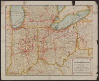
Abstract:
Outline map showing the railroad network and stations along the rail lines. [From published bibliography].
Description:
"Chas. Shober Lith. 109 Lake St. Chicago." and Imperfect: Mutilated.
Publisher:
S. Chapman,
Subject (Topic):
Railroads--Middle West--Maps
Found in:
Beinecke Rare Book and Manuscript Library > Chapman's rail road map of Ohio, Indiana, Michigan, Illinois, Missouri, Minnesota, & Wisconsin.
Published / Created:
1915
Call Number:
754gme 1915
Container / Volume:
BRBL_00420
Image Count:
2
Resource Type:
Maps, Atlases & Globes
Alternative Title:
, Ohio, and Michigan
Description:
Alpha-numeric grid along margins., On verso: Index of cities and towns., and Shows railways between Illinois, Indiana and cities within connecting states.
Publisher:
s.n.,
Subject (Geographic):
Illinois--Maps and Indiana--Maps
Found in:
Beinecke Rare Book and Manuscript Library > Official Interurban map issued by the Terre Haute, Indianapolis & Eastern Traction Company : 425 miles in Indiana and Illinois, connecting with interurban railways in Indiana, Ohio, and Michigan.
Creator:
Published / Created:
1848
Call Number:
80 1848C
Container / Volume:
BRBL_00533
Image Count:
1
Resource Type:
Maps, Atlases & Globes
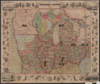
Alternative Title:
through the states of Ohio, Michigan , Indiana
Description:
, Michigan , Indiana, Illinois, Missouri, Iowa
Publisher:
Ensigns & Thayer,
Subject (Geographic):
Middle West--Maps
Found in:
Beinecke Rare Book and Manuscript Library > Map of the western states / drawn & engraved by J.M. Atwood.
Published / Created:
[1843?]
Call Number:
755 1843A
Container / Volume:
BRBL_00441
Image Count:
1
Resource Type:
Maps, Atlases & Globes
Publisher:
David H. Burr,
Subject (Geographic):
Canada--Maps and East (U.S.)--Maps
Found in:
Beinecke Rare Book and Manuscript Library > Map exhibiting the country between Lakes Michigan and Erie and the contested boundary lines.
Branch:v1.61.8 ,Deployed:2024-06-20T11:14:48-04:00