Search
You Searched For
Search Results
- Creator:
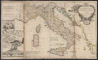
- Moll, Herman, -1732
- Published / Created:
- 1714
- Call Number:
- 40 1714
- Container / Volume:
- BRBL_00196
- Image Count:
- 1
- Resource Type:
- Maps, Atlases & Globes
- Found in:
- Beinecke Rare Book and Manuscript Library > A new map of Italy : distinguishing all the sovereignties in it, whether states, kingdoms, dutchies, principalities, republicks &c. With the post roads, and many remarks not extant in any map. According to ye newest and most exact observations / by H. Mol
- Creator:
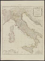
- Kitchin, Thomas, d. 1784
- Published / Created:
- 1794
- Call Number:
- 40 1794
- Container / Volume:
- BRBL_00198
- Image Count:
- 1
- Resource Type:
- Maps, Atlases & Globes
- Found in:
- Beinecke Rare Book and Manuscript Library > A new map of Italy with the islands of Sicily, Sardinia & Corsica / from Monsr. d'Anville: to which have been added the post roads and several other improvements.
- Creator:
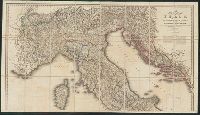
- Wyld, James, 1812-1887, cartographer
- Call Number:
- 40 1845B
- Container / Volume:
- BRBL_00200
- Image Count:
- 2
- Resource Type:
- Maps, Atlases & Globes
- Found in:
- Beinecke Rare Book and Manuscript Library > A new map of Italy, including the southern parts of Germany and the kingdom of Illyria : distinguishing their natural features and political divisions, post roads and stations with the number of posts between each station.
- Published / Created:
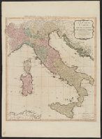
- 1790
- Call Number:
- 40 1790
- Container / Volume:
- BRBL_00198
- Image Count:
- 1
- Resource Type:
- Maps, Atlases & Globes
- Found in:
- Beinecke Rare Book and Manuscript Library > A new map of Italy, with the islands of Sicily, Sardinia & Corsica / from Monsr. d'Anville ...
- Creator:
- Bowles, Carington, 1724-1793, creator
Sheffield, 18th cent
- Published / Created:
- [ca. 1762]
- Call Number:
- 2003 Folio 85
- Image Count:
- 1
- Found in:
- Beinecke Rare Book and Manuscript Library > A new map of Jamaica: in which the several towns, forts, & settlements are accurately laid down, as well as the situations & depths of the most noted harbours and anchoring places
- Creator:
- Holmes, William Henry, 1846-1933
- Published / Created:
- [1859?]
- Call Number:
- 825 1859A
- Container / Volume:
- BRBL_00573
- Image Count:
- 1
- Resource Type:
- Maps, Atlases & Globes
- Found in:
- Beinecke Rare Book and Manuscript Library > A new map of Kansas / by W.H. Holmes.
- Creator:
- Wells, Edward, 1667-1727
- Published / Created:
- 172-?]
- Call Number:
- 400 172XA
- Container / Volume:
- BRBL_00232
- Image Count:
- 1
- Resource Type:
- Maps, Atlases & Globes
- Found in:
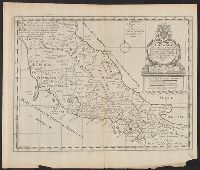
- Beinecke Rare Book and Manuscript Library > A new map of Latium, Etruria, and as much of antient Italy as lay between Gallia Cisalpina and Graecia Magna, shewing their principal divisions, cities, towns, rivers, mountains, &c. / Sutton Nicholls sculp.
- Published / Created:
- 1720
- Call Number:
- 32 L84 1720
- Container / Volume:
- BRBL_00048
- Image Count:
- 1
- Resource Type:
- Maps, Atlases & Globes
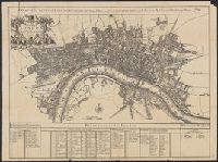
- Found in:
- Beinecke Rare Book and Manuscript Library > A new map of London ... 1720 Revised by Ino. Senex. S. Parker Delin. et sculpt.
- Call Number:
- Zc20 720so
- Collection Title:
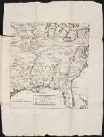
- Some considerations on the consequences of the French settling colonies on the Mississippi, with
- Image Count:
- 1
- Found in:
- Beinecke Rare Book and Manuscript Library > A new map of Louisiana and the River Mississipi
- Published / Created:
- 1833
- Call Number:
- 2002 Folio 97
- Collection Title:
- Tanner’s universal atlas : subscription price $1.00 a number, seperate [sic] numbers $1.50 each
- Image Count:
- 1
- Resource Type:
- Maps, Atlases & Globes
- Found in:
- Beinecke Rare Book and Manuscript Library > A new map of Maine