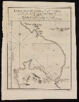
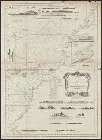
"No. 15" in upper right corner; "VII.D." in lower right corner., From Almindelig histoirie over reiser til lands og bands ... (Kjøbenhavn: Niels Hansen Møller, 1749), a translation of Collection of voyages and travels edited by Awnsham Chruchill and Thomas Osborne., Relief shown pictorially; depths by soundings., and Watermark.
Publisher:
[Niels Hansen Møller],
Subject (Geographic):
--Earlyworksto1800.
Subject (Name):
Bellin, Jacques Nicolas, 1703-1772, Churchill, Awnsham, -1728. Collection of voyages and travels. Danish., Møller, Niels Hansen, and Osborne, Thomas, -1767. Collection of voyages and travels. Danish.
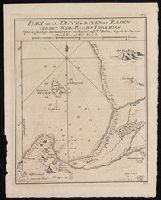
Plan of Table Bay at Cape Town and the Cape of Good Hope in present-day South Africa.
Description:
"No. 4" in upper right corner; "VII.D." in lower right corner., From Almindelig histoirie over reiser til lands og bands ... (Kjøbenhavn: Niels Hansen Møller, 1749), a translation of Collection of voyages and travels edited by Awnsham Chruchill and Thomas Osborne., and Relief shown pictorially; depths shown by soundings.
Publisher:
[Niels Hansen Møller],
Subject (Geographic):
Table Bay (South Africa)--Maps--Early
Subject (Name):
Bellin, Jacques Nicolas, 1703-1772, Churchill, Awnsham, -1728. Collection of voyages and travels. Danish., Møller, Niels Hansen, and Osborne, Thomas, -1767. Collection of voyages and travels. Danish.
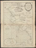
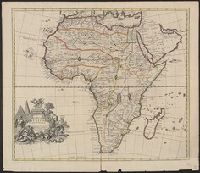
"For Mr. Postlethwayt's Universal dictionary of trade & commerce." and Includes ill., text, and inset of "A separate map of the Gold Coast upon a larger scale."
Publisher:
Printed for H. Woodfall [etc.],
Subject (Geographic):
Africa, West--Maps--Earlyworksto1800
Subject (Name):
Postlethwayt, Malachy, 1707?-1767. Universal dictionary of trade and commerce
Anville, Jean Baptiste Bourguignon d', 1697-1782 Compagnie des Indes Jefferys, Thomas, d. 1771, creator Kitchin, Thomas, d. 1784 Robert Laurie and James Whittle Sayer, Robert, 1725-1794
Published / Created:
1789 January 1
Call Number:
1982 Folio 10
Image Count:
1
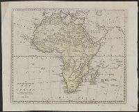
Description:
Also appeared in Kitchin's General atlas describing the whole universe. London : Printed for Robert Sayer, [1780]., Has illustrated cartouche and includes text., No. 36 of 43 maps bound together in composite atlas., Norwich, O.I. Norwich's maps of Africa., Prime meridians: Ferro and London., Relief shown pictorially; depths by soundings., Scale [ca. 1:1,850,000]., and This map is copied from an original drawn by Monsr. D'Anville at the expense of the French East India Company, & published at Paris. The country thorough [sic] which the R. Senegal runs has been improved & corrected from a large & curious survey of that river found in the Fort of Senegal.
"This map is copied from an original drawn by Monsr. D'Anv, Also appeared in Kitchin's General atlas describing the whole universe. London : Printed for Robert Sayer, [1780]., Prime meridians: Ferro and London., and Relief shown pictorially; depths by soundings.
Publisher:
Printed for Robert Sayer,
Subject (Geographic):
Africa, West--Maps--Earlyworksto1800
Subject (Name):
Abbot, Charles,--Baron Colchester,--1757-1829--Bookplate, Anville, Jean Baptiste Bourguignon d', 1697-1782, Kitchin, Thomas, d. 1784. General atlas describing the whole universe, and Robert Laurie and James Whittle
"Iohan. Senex scu, Imprint derived from other maps in the same atlas., London meridian., Ms. no. on verso: 34. Sheet measures 53 x 68 cm. Cross Collection no. 96., Relief shown pictorially., and Shows boundaries, forests, rivers, roads and settlements, with notes.
Publisher:
John Senex,
Subject (Geographic):
Mediterranean Region--Historical geography--Early works to 1800--Maps
"Most humbly inscrib'd to ye most honoble. the Marquis of Annandale, kt. of the most noble & ancient Order of the Thistle.", Appears in the Senex's New general atlas. 1721., Includes ornamental cartouche., Prime meridian: London., and Relief shown pictorially.