Bowen, Emanuel, d. 1767 Cook, James, fl. 1766, creator
Published / Created:
Decr. 1766
Call Number:
2003 Folio 85
Image Count:
1
Description:
BEIN 2003 Folio 85: No. 24 of 45 maps bound together with binder's spine title: Atlas of America; ms. table of contents. Bookplate: Robinson. Bookplate of Paul Mellon., by their humble servt. James Cook ; approv'd of by Mr. Joiner 20 years a pilot of that place., Depths shown by soundings., Emanl. Bowen sculpt., Hand colored., and Scale [1:65,000].
Publisher:
By the author
Subject (Geographic):
Port Royal (S.C.) -- Maps -- Early works to 1800
Subject (Topic):
Nautical charts -- Port Royal (S.C.) -- Early works to 1800
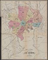
Imperfect: upper left corner cut-out, with some loss of text., Includes text in upper right corner: Population s, and Map of London showing railways, stations, postal boundaries, parks, omnibus and tram routes, steamboat piers and steamboat routes.
Publisher:
Published by Letts, Son & Co., London Bridge, E.C.,
Copy 1: Advertising on verso: Evan Evans ... tinsmith, plumber, and gas-fitter; John C. Ritter ... marble and granite monuments; the Smith Granite Co., Westerley, R.I.
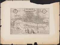
"The Topographic Etching Co., ph. sc.", Alternate title: London, 1572, by Braun and Hogenberg., Bird's-eye-view., Facsimile., Has watermark., Includes 2 texts in Latin, 2 coats of arms, and illus. of human figures., Place names in English., and Reproduced from Braun
Publisher:
Topographical Society of London,
Subject (Geographic):
London (England)--Aerial views--Early works to 1800--Facsimiles
Dominican Republic --Economic conditions --20th century, Dominican Republic --Foreign relations --United States, Dominican Republic --History --20th century, Dominican Republic --Politics and government --20th century, Haiti --Economic conditions --20th century, Haiti --Foreign relations --United States, Haiti --History --American occupation, 1915-1934, Haiti --Politics and government --20th century, United States --Foreign relations --Dominican Republic, and United States --Foreign relations --Haiti
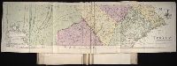
Map of the improved part of the province of Pennsylvania
Description:
BEIN 2003 Folio 85: No. 20 of 45 maps bound together with binder's spine title: Atlas of America; ms. table of contents. Bookplate: Robinson. Bookplate of Paul Mellon., Hand colored., Relief shown pictorially., Scale [ca. 1:250,000]., and Shows county boundaries.
Publisher:
Sold by the author, Nicholas Scull
Subject (Geographic):
Pennsylvania -- Administrative and political divisions -- Maps -- Early works to 1800 and Pennsylvania -- Maps -- Early works to 1800
Map of the improved part of the province of Pennsylvania
Description:
2nd state of 2 known states. Distinguishing features of 2nd state: "Four [sic] long lines of text have been added at right of the Narrows of the Susquehannah at Nelson's Ferry. A road now leads east from Carlisle direct to Pine Ford" (Wheat and Brun 89).
Publisher:
sold by the author Nicholas Scull,
Subject (Geographic):
Pennsylvania--Administrative and political divisions--Maps--Early works to 1800 and Pennsylvania--Maps--Early works to 1800
Subject (Name):
Davis, John, fl. 1756-1759, Penn, Richard, 1706-1771. dedication, Penn, Thomas, 1702-1775. dedication, and Turner, James, d. 1759. engraver
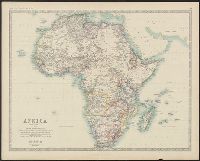
Boundaries hand colored., From Johnston's Royal atlas of modern geography., Prime meridian: Greenwich., Relief shown by hachures., Upper left: Keith Johnston's general atlas., and Upper right: 39.
Subject (Geographic):
Africa--Maps
Subject (Name):
Johnston, Alexander Keith, 1804-1871. Royal atlas of modern geography and W. & A.K. Johnston Limited