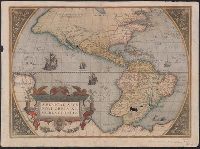
From Ortelius's Theatrum oder Schawbüch des Erdtkreijs [Antwerp : Christophe Plantin, Abraham Ortelius, 1580]., Latin and German., Several small holes in lower regions of South America where oxidized by pigment., Sheet measures 40 x 55 cm. Lanman Collection., Signature on verso: 5., Text on verso: Die newe Welt., and The viewer looks into the sails of the ship at 220 degrees of longitude.
Publisher:
Christophe Plantin, Abraham Ortelius,
Subject (Geographic):
America--Maps--Early works to 1800 and Western Hemisphere--Maps--Early works to 1800
Subject (Name):
Ortelius, Abraham, 1527-1598. Theatrum orbis terrarum. German and Plantin, Christophe, approximately 1520-1589
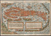
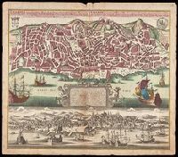
Contrafhetung der fuernemen statt Venedig sampt den umbligenden inseln
Description:
Bird's-eye view., From Münster's Cosmographei [Basel : Heinrich Petri, 1550], pp. 187-190., German, Latin., Pg. nos. on recto: 188, 189. Pg. nos. on verso: 187, 190., Relief shown pictorially., and Signature on recto: Q iii. Signature on verso: Q ii.
Publisher:
Heinrich Petri,
Subject (Geographic):
Venice (Italy)--Maps--Early works to 1800
Subject (Name):
Münster, Sebastian, 1489-1552. Cosmographei. German and Petri, Heinrich, 1508-1579
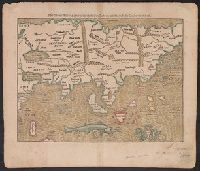
Laender Asie nach ihrer Gelegenheit biβ in Indiam, werden in dieser Tafeln verzeichnet
Description:
Appears in the author's Cosmographia., German, Latin., Hand col. Sheet measures 35 x 40 cm. Lanman Collection., Text, ill., "xxiiij" on verso., and Title on verso: India neuw.
Publisher:
H. Petri,
Subject (Geographic):
Asia--Maps--Early works to 1800
Subject (Name):
Münster, Sebastian, 1489-1552. Cosmographia and Petri, Heinrich, 1508-1579
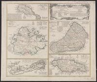
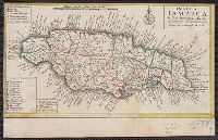
Cross Collection no. 245., Imperfect: map of Jamaica cut-out. Two maps (Antigua and Barbados)., Includes explanatory notes and index., Relief shown pictorially., Scales in millaria Anglica communia and/or millaria Anglica statuta., and Sheet title in Latin and German. Individual map titles and text in German. Maps in English and German.
Publisher:
Homann Erben,
Subject (Geographic):
Antigua--Maps--Early works to 1800, B, Barbados--Maps--Early works to 1800, Jamaica--Maps--Early works to 1800, Saint Kitts and Nevis--Maps--Early works to 1800, and West Indies--Maps--Early works to 1800
Cross Collection no. 253., Includes explanatory notes and index., Ms. notes in upper right corner., Relief shown pictorially., Scales in millaria Anglica communia and/or millaria Anglica statuta., Sheet title in Latin and German. Individual map titles and text in German. Maps in English and German., and Three maps (Antigua, Barbados, Jamaica). Mounted on linen.
Publisher:
Homann Erben,
Subject (Geographic):
Antigua--Maps--Early works to 1800, Barbados--Maps--Early works to 1800, Bermuda Islands--Maps--Early works to 1800, Jamaica--Maps--Early works to 1800, and Saint Kitts and Nevis--Maps--Early works to 1800
From Münster's Cosmographia., Hand col. Sheet measures 34.5 x 40 cm. Lanman Collection., Oriented with north to the bottom., Recto: German, Latin. Verso: German., Relief shown pictorially., Text, ill., "iii" on verso., and Title on verso: Neüw Europa.
Publisher:
Heinrich Petri,
Subject (Geographic):
Europe--Maps--Early works to 1800
Subject (Name):
Münster, Sebastian, 1489-1552. Cosmographia and Petri, Heinrich, 1508-1579, publisher
Appears on sheet Die Englische Colonie-Laender ... [Nürnberg] : Homaennische Erben, [ca. 1740], with, Cross Collection no. 282., Relief shown pictorially., and Title in Latin, explanations in German, and map locations in English.
Lisabon die prächtigste Königl. Residenz Statt in Portugall u. florisanteste Handels Plaz am Austfluss des Tagi
Description:
"Cum gratia et privil. S.R.I. Vicariatus in partibus Rheni, Suevice, et Juris Franconici.", Historiated cartouche with note., Includes aerial view of "Lisabon" at bottom., and Manuscript number in upper right corner. From the Karpinski-von Wieser Map Collection.
Publisher:
[Matthaeus Seutter]
Subject (Geographic):
Lisbon (Portugal)--Aerial views--Early works to 1800, Lisbon (Portugal)--Maps--Early works to 1800, and Portugal--Lisbon
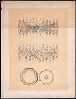
Mappa Aestivarvm insularum, alias Barmvdas dictarum
Description:
Below map, list of proprietors in 12 columns flanked by coats-of-arms., Borders are hand colored., and Not hand colored. With watermark. Sheet measures 46 x 55 cm.