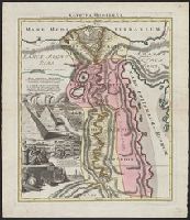
"Joannes Christophorus I.B. Homanni filius delineavit. Cum privilegio Sac. Caes. Majestatis.", Hand col. Sheet measures 65.5 x 56.5 cm., Includes illustrations of cataracts of the Nile, the pyramids, tombs, various antiquities, sce, and Relief shown by hachures.
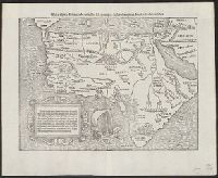
German title and text, Latin place names., Includes text and ill., Relief shown pictorially., Sheet measures 34 x 42 cm., and Text in ornamental frame on verso: Des gantzen Landts Africe, ein gemeine beschreibung. xxv.
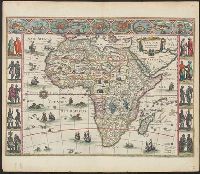
"Cum privilegio ad decennium.", Appears in C. and J. Blaeu's Novus atlas of 1641-1642, J. Blaeu's Novus atlas of, Includes col. ill. of ships, monsters, etc., and of African peoples and 9 city views in border., Signature on verso: A., and Title on verso: Africa.
Appears in various eds. of Atlas geographicus maior., Includes German text relating to English and French territorial claims., Neat lines measures 45.8 x 50.8 cm. on sheet 50 x 57.5 cm. Ms. note on verso: No. 151, Nord America nach d'Anville. Franklin Collection no. 131 1756-9., Place names and descriptive notes in English., Prime meridian: Ferro and London., and Relief shown pictorially.
Publisher:
[Homann Erben],
Subject (Geographic):
North America--Maps--Early works to 1800 and United States--History--French and Indian War, 1755-1763--Maps--Early works to 1800
Subject (Name):
Anville, Jean Baptiste Bourguignon d', 1697-1782 and Homann Erben (Firm). Atlas geographicus maior
755 1756E: Mounted on paper. Neat line measures 45.9 x 51 cm. on sheet 46 x 51.2 cm. Ms. no.: 54., Includes German text relating to English and French territorial claims., Prime meridian: Ferro and London., Relief sh, and Sheet measures 49.5 x 57.2 cm.
Publisher:
[Homann Erben],
Subject (Geographic):
North America--Maps--Early works to 1800 and United States--History--French and Indian War, 1755-1763--Maps--Early works to 1800
Subject (Name):
Anville, Jean Baptiste Bourguignon d', 1697-1782 and Homann Erben (Firm). Atlas geographicus maior
Appears in various eds. of Atlas geographicus maior., Includes German text relating to English and French territorial claims., Mounted on paper. Neat line measures 45.9 x 51 cm. on sheet 46 x 51.2 cm. Ms. no.: 54., and Place names and descriptive notes in Englis
Publisher:
[Homann Erben],
Subject (Geographic):
North America--Maps--Early works to 1800 and United States--History--French and Indian War, 1755-1763--Maps--Early works to 1800
Subject (Name):
Anville, Jean Baptiste Bourguignon d', 1697-1782 and Homann Erben (Firm). Atlas geographicus maior
Appears in various eds. of Atlas geographicus maior., Includes German text relating to English and French territorial claims., Place names and descriptive notes in English., Prime meridian: Ferro and London., Relief shown pictorially., and Sheet measures 47.1 x 52 cm. Ms. no. on verso: No. 5. Cross Collection no. 194.
Publisher:
[Homann Erben],
Subject (Geographic):
North America--Maps--Early works to 1800 and United States--History--French and Indian War, 1755-1763--Maps--Early works to 1800
Subject (Name):
Anville, Jean Baptiste Bourguignon d', 1697-1782 and Homann Erben (Firm). Atlas geographicus maior
Appears in various eds. of Atlas geographicus maior., Includes German text relating to English and French territorial claims., Place names and descriptive notes in English., Prime meridian: Ferro and London., Relief shown pictorially., and Sheet measures 49.5 x 61.7 cm. Title in ms. on verso. Franklin Collection no. 131 1777-1.
Publisher:
[s.n.],
Subject (Geographic):
North America--Maps--Early works to 1800 and United States--History--French and Indian War, 1755-1763--Maps--Early works to 1800
Subject (Name):
Anville, Jean Baptiste Bourguignon d', 1697-1782 and Homann Erben (Firm). Atlas geographicus maior
America, die newe Welt oder Inseln so hinder Hispania gegen Orient bey dem Landt Indie gelegen and Newen Inseln so hinder Hispaniam gegen Orient bey dem Landt Indie gelegen
Description:
Appeared in Münster's Cosmographia., Covers also the Pacific including New Guinea and Antarctica, i.e. Meridies terra del fuego., In the right-hand panel of text surmounting the map, the words Nova Francia appear in italic text rather than roman and the last word in the second line is Spanien., On verso: America, die newe Welt/ oder Inseln/ so hinder His-pania gegen Orient / bey dem Landt Indie gelegen. XXVI., Relief shown pictorially., Sheet measures 33.4 x 39.3 cm. Cross Collection no. 113., Text in German; place names in Latin or Spanish., and Title at top: Die newen Inseln/ so hinder Hispania gegen Orient/ bey dem Landt Indie gelegen.
Publisher:
s.n.,
Subject (Geographic):
America--Maps--Early works to 1800, Pacific Ocean--Maps--Early works to 1800, and Western Hemisphere--Maps--Early works to 1800
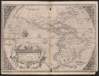
Caption title on verso: Die Newe Welt; numbered "2" in lower right corner., From a German edition of Ortelius's Theatrum orbis terrarum, published either 1572 or 1573., Imperfect: wormholes, with some loss of text. Sheet measures 39.8 x 52.3 cm. Cross Collection no. 111., Latin text on recto, German text on verso., and Relief shown pictorially.
Publisher:
s.n.,
Subject (Geographic):
America--Maps--Early works to 1800
Subject (Name):
Ortelius, Abraham, 1527-1598. Theatrum orbis terrarum. German