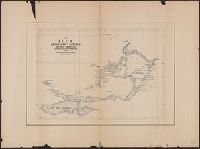
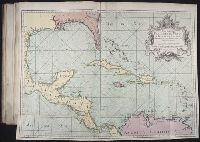
BEIN 2003 Folio 85: No. 27 of 45 maps bound together with binder's spine title: Atlas of America; ms. table of contents. Bookplate: Robinson. Bookplate of Paul Mellon.
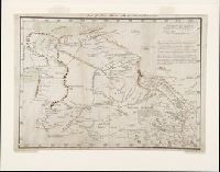
Manuscript map, in color, drawn by Bernardo Miera y Pacheco in San Felipe, Chihuahua, Mexico, in 1778. It documents the efforts of the Dominguez-Escalante expedition to explore the interior of western North America including parts of present day New M...
Description:
Bernardo Miera y Pacheco was the cartographer on the Domínguez-Escalante Expedition. The expedition of ten men, led by Franciscan Fathers Francisco Atanasio Domínguez and Silvestre Vélez de Escalante, departed Sante Fe in late July 1776 and returned t...
Subject (Geographic):
Arizona, Colorado, New Mexico, Southwest, New, and Utah
Subject (Name):
Miera y Pacheco, Bernardo de., Domínguez, Francisco Atanasio, active 1776., Vélez de Escalante, Silvestre, -1792., and Domínguez-Escalante Expedition
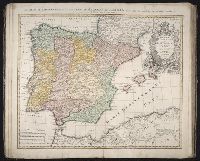
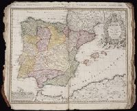
Regnorvm Hispaniae et Portvgalliae tabula generalis de l'Isliana and Reyno de Espanna dividido en dos grandes estados de Aragón y de Castilla, subdividido en muchas provincias donde se halla también el Reyno de Portugal
Description:
BEIN 1973 Folio 30: Imperfect: torn along fold, with no loss of text. Sheet measures 53.9 x 62 cm. No. 5 of 32 maps bound together.
Reyno de Espanna dividido en dos grandes estados de Aragón y de Castilla, subdividido en muchas provincias donde se halla también el Reyno de Portvgal
Description:
BEIN 1975 Folio 31: Imperfect: torn along fold and frayed along edges, with no loss of text. Sheet measures 53.2 x 60.7 cm. No. 4 of 42 maps bound together.