Search
You Searched For
Search Results
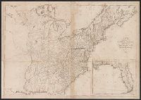
- Creator:
- Pike, Zebulon Montgomery, 1779-1813
- Published / Created:
- 1810
- Call Number:
- GA405 +W44 (LC)
- Collection Title:
- Mapping the transmississippi West, 1540-1861
- Image Count:
- 1
- Description:
- Bound in between p. 24-25. and Map 297 from table of contents.
- Publisher:
- C. & A. Conrad, & Co
- Subject (Geographic):
- Louisiana--Maps, New Mexico--Maps, North America--Maps, and West (U.S.)--Maps
- Collection Created:
- San Francisco, Institute of Historical Cartography, 1957-63
- Found in:
- Beinecke Rare Book and Manuscript Library > A Chart of the Internal Part of Louisiana, Including all the hitherto unexplored Countries, lying between the River La Platte of the Missouri on the N: and the Red River on the S: the Mississippi East and the Mountains of Mexico West; with a Part of New M
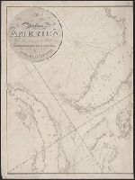
- Creator:
- Stockdale, John, 1749?-1814
- Published / Created:
- 1800 Nov. 24
- Call Number:
- CF1921 E38 1801
- Collection Title:
- An historical survey of the island of Saint Domingo, together with an account of the Maroon negroes
- Image Count:
- 1
- Resource Type:
- Maps, Atlases & Globes
- Description:
- Between p. 224-225.
- Subject (Geographic):
- Jamaica and West Indies
- Subject (Topic):
- Indians of the West Indies --Jamaica
- Collection Created:
- London,
- Found in:
- Beinecke Rare Book and Manuscript Library > A Map of the Island of St. Domingo