Search
You Searched For
Search Results
- Published / Created:
- 1916
- Call Number:
- 855gck 1916
- Container / Volume:
- BRBL_00642
- Image Count:
- 1
- Resource Type:
- Maps, Atlases & Globes
- Found in:
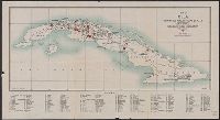
- Beinecke Rare Book and Manuscript Library > Map of Cuba : showing all working sugar estates.
- Published / Created:
- [1898]
- Call Number:
- 855hc 1898O
- Container / Volume:
- BRBL_00765
- Image Count:
- 1
- Resource Type:
- Maps, Atlases & Globes
- Found in:
- Beinecke Rare Book and Manuscript Library > Map of Santiago de Cuba showing intrenchments and position of the 5th Corps. U.S. Army and those of the Spanish / compiled from partial transit surveys and foot reconnaisance notes and sketches by Lts. Guy, Smith, Cordray. of the Inf.; Lts. Batson and G.P
- Published / Created:
- [1898]
- Call Number:
- 855hc 1898L
- Container / Volume:
- BRBL_00765
- Image Count:
- 1
- Resource Type:
- Maps, Atlases & Globes
- Found in:
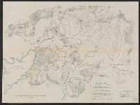
- Beinecke Rare Book and Manuscript Library > Map of Santiago de Cuba showing intrenchments and positions of the Fifth Corps. U.S. Army and those of the Spanish after the taking of Caney and San Juan Hill, evening of July 1st, 1898 / compiled from partial transit surveys and foot reconnaisance notes
- Creator:
- United States. Adjutant-General's Office. Military Information Division
- Published / Created:
- 1898]
- Call Number:
- 855hc 1898E
- Container / Volume:
- BRBL_00765
- Image Count:
- 1
- Resource Type:
- Maps, Atlases & Globes
- Found in:
- Beinecke Rare Book and Manuscript Library > Map of operations of 12th U.S. Infantry at Caney, Cuba, July 1, 1898 / by Willis Uline, 1st. Lieut., 12th Infantry.
- Creator:
- Matthews-Northrup Company
- Published / Created:
- [1906?]
- Call Number:
- 792 1906
- Container / Volume:
- BRBL_00519
- Image Count:
- 1
- Resource Type:
- Maps, Atlases & Globes
- Found in:
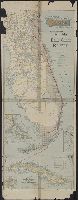
- Beinecke Rare Book and Manuscript Library > Map of the peninsula of Florida and adjacent islands, Florida East Coast Railway.
- Published / Created:
- 1898]
- Call Number:
- 855hc 1898C
- Container / Volume:
- BRBL_00765
- Image Count:
- 1
- Resource Type:
- Maps, Atlases & Globes
- Found in:
- Beinecke Rare Book and Manuscript Library > Map showing roughly the course of troop D, tenth cavalry, July 1st, 1898, after leaving the regiment, and teh general direction of the attack made by the regiment.
- Creator:
- C.S. Hammond & Company
- Published / Created:
- c1906.
- Call Number:
- 855 1906
- Container / Volume:
- BRBL_00641
- Image Count:
- 2
- Resource Type:
- Maps, Atlases & Globes
- Found in:
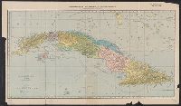
- Beinecke Rare Book and Manuscript Library > New and complete map of Cuba / C.S. Hammond & Co., N.Y.
- Creator:
- Shewey, A. C
- Published / Created:
- [1898]
- Call Number:
- 855 1899
- Container / Volume:
- BRBL_00641
- Image Count:
- 2
- Resource Type:
- Maps, Atlases & Globes
- Found in:
- Beinecke Rare Book and Manuscript Library > Official map of Cuba.
- Published / Created:
- c1892.
- Call Number:
- 855 1892A
- Container / Volume:
- BRBL_00641
- Image Count:
- 2
- Resource Type:
- Maps, Atlases & Globes
- Found in:
- Beinecke Rare Book and Manuscript Library > Rand McNally & Co.'s New 14 x 21 map of the West Indies.
- Published / Created:
- c1892.
- Call Number:
- 855 1892
- Container / Volume:
- BRBL_00641
- Image Count:
- 2
- Resource Type:
- Maps, Atlases & Globes
- Found in:
- Beinecke Rare Book and Manuscript Library > Rand McNally & Co.'s indexed atlas of the world : Map of Cuba.