Skip to search
Skip to main content
Skip to first result
Search
You Searched For
Genre
Maps
Subject (Geographic)
Europe, Central--Maps
New Search
Search Results
Creator:
Published / Created:
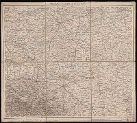
1882-1886.
Call Number:
304 1886
Container / Volume:
Series Box 1
Image Count:
6
Resource Type:
Maps, Atlases & Globes
Description:
Copy 2: Imperfect: all sheets but C1, C2, D1, D2, E1 and E2 wanting., Covers Europe from western France to eastern Russia, and from the North Sea to the Aegean Sea., and Relief shown by hachures and spot heights.
Publisher:
K.K. Militär-geographisches Institute,
Subject (Geographic):
Europe, Central--Maps
Found in:
Beinecke Rare Book and Manuscript Library > Übersichts-Karte von Mittel-Europa, im Masse 1:750.000 der Natur / bearbeitet und herausgegeben vom K.K. Militär-geographischen Institute.
Creator:
Published / Created:
1887
Call Number:
304ed 1887
Container / Volume:
BRBL_00034A
Image Count:
1
Resource Type:
Maps, Atlases & Globes
Publisher:
Dietrich Reimer,
Subject (Geographic):
Europe, Central--Maps
Subject (Topic):
Linguistic geography--Germany--Maps
Found in:
Beinecke Rare Book and Manuscript Library > Übersichtskarte der Verbreitung der Deutschen in Europa.
Published / Created:
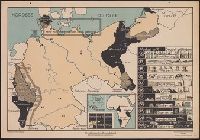
[1933]
Call Number:
36 1919
Container / Volume:
BRBL_00121
Image Count:
1
Resource Type:
Maps, Atlases & Globes
Description:
In lower right corner of margin: Nr. 162. Text dazu in "Schulmann" Heft 7/1933., Inset: Verlorene Kolonien., and Shows German losses after World War 1.
Publisher:
Verlag der praktische Schulmann,
Subject (Geographic):
Europe, Central--Maps, Germany--Colonies--Maps, Germany--History--1918-1933--Maps, and Germany--Industries--Maps
Found in:
Beinecke Rare Book and Manuscript Library > Verstümmeltes Deutschland / nach einer Originalzeichnung von Erich Haferkorn ; Offsetdruckerei Fricke & Co.
Published / Created:
1855
Call Number:
304hc 1855A
Container / Volume:
BRBL_00035
Image Count:
2
Resource Type:
Maps, Atlases & Globes
Publisher:
G.S. Wells,
Subject (Geographic):
Europe, Central--Maps
Found in:
Beinecke Rare Book and Manuscript Library > Wells' new map of the Seat of war.
Published / Created:
1855
Call Number:
304hc 1855
Image Count:
1
Resource Type:
Maps, Atlases & Globes
Alternative Title:
Ground plan of siege operations before Sebastopol.
Description:
Imperfect: publisher's name and date of publication faintly printed; torn in upper right corner, with some loss of text. and Relief shown pictorially.
Publisher:
G.S. Wells,
Subject (Geographic):
Europe, Central--Maps
Subject (Topic):
Crimean War, 1853-1856--Maps
Found in:
Beinecke Rare Book and Manuscript Library > Wells' new map of the seat of war / compiled from the latest German and Austrian surveys and comprising the Black Sea, Crimea, Danubian provinces, Russia, Turkey in Asia, etc., with plan of Kronstadt, St. Petersburg and ground plan of siege operations bef
Published / Created:
[1865?]
Call Number:
304 1865
Container / Volume:
BRBL_00033
Image Count:
1
Resource Type:
Maps, Atlases & Globes
Subject (Geographic):
Europe, Central--Maps
Found in:
Beinecke Rare Book and Manuscript Library > [Central Europe].
Published / Created:
1945
Call Number:
304cbf 1945A
Container / Volume:
BRBL_00034A
Image Count:
1
Resource Type:
Maps, Atlases & Globes
Publisher:
Mil. Geo.,]
Subject (Geographic):
Europe, Central--Maps
Found in:
Beinecke Rare Book and Manuscript Library > [Central Europe].
Published / Created:
1919?]
Call Number:
11hcf 1919B-12
Container / Volume:
BRBL_00010O
Image Count:
1
Resource Type:
Maps, Atlases & Globes
Description:
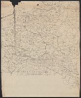
Imperfect: Partial map in 3 fragments.
Publisher:
s.n.,
Subject (Geographic):
Europe, Central--Maps
Found in:
Beinecke Rare Book and Manuscript Library > [Map of Central Europe].
Published / Created:
1919?]
Call Number:
11hcf 1919B-18
Container / Volume:
BRBL_00010O
Image Count:
1
Resource Type:
Maps, Atlases & Globes
Description:
Title supplied by cataloger.
Publisher:
s.n.,
Subject (Geographic):
Europe, Central--Maps
Subject (Topic):
Boundaries--Europe, Central--1919
Found in:
Beinecke Rare Book and Manuscript Library > [Map of central Europe].
Branch:v1.61.6 ,Deployed:2024-06-12T09:55:31-04:00