Search
You Searched For
Search Results
- Published / Created:
- [1774]
- Call Number:
- 76 1774
- Container / Volume:
- BRBL_00729
- Image Count:
- 1
- Resource Type:
- Maps, Atlases & Globes
- Found in:
- Beinecke Rare Book and Manuscript Library > A Map of the most inhabited part of New England [cartographic material] : containing the provinces of Massachusets Bay and New Hampshire with the colonies of Conecticut and Rhode Island divided into counties and townships : The whole composed from actual
- Published / Created:
- [1774]
- Call Number:
- 76 1774
- Container / Volume:
- BRBL_00729
- Image Count:
- 2
- Resource Type:
- Maps, Atlases & Globes
- Found in:
- Beinecke Rare Book and Manuscript Library > A Map of the most inhabited part of New England [cartographic material] : containing the provinces of Massachusets Bay and New Hampshire with the colonies of Conecticut and Rhode Island divided into counties and townships : The whole composed from actual
- Published / Created:
- [1774]
- Call Number:
- 76 1774
- Container / Volume:
- BRBL_00443
- Image Count:
- 2
- Resource Type:
- Maps, Atlases & Globes
- Found in:
- Beinecke Rare Book and Manuscript Library > A Map of the most inhabited part of New England [cartographic material] : containing the provinces of Massachusets Bay and New Hampshire with the colonies of Conecticut and Rhode Island divided into counties and townships : The whole composed from actual
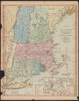
- Published / Created:
- 1819
- Call Number:
- 76 1819
- Container / Volume:
- BRBL_00443
- Image Count:
- 1
- Resource Type:
- Maps, Atlases & Globes
- Found in:
- Beinecke Rare Book and Manuscript Library > A map of Massachusetts, Connecticut, and Rhodeisland humbly sumitted to the Citizens thereof by ... E. Ruggles.
- Published / Created:
- 1780
- Call Number:
- 76hc 1777
- Container / Volume:
- BRBL_00446A
- Image Count:
- 1
- Resource Type:
- Maps, Atlases & Globes
- Found in:
- Beinecke Rare Book and Manuscript Library > A map of the country in wich the army under Lt. General Burgoyne acted in the campaing of 1777, shewing the marches of the army & the places of the principal actions.
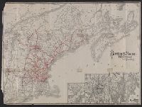
- Creator:
- Rand Avery Supply Co
- Published / Created:
- [1911?]
- Call Number:
- 76gme 1910
- Container / Volume:
- BRBL_00446A
- Image Count:
- 1
- Resource Type:
- Maps, Atlases & Globes
- Found in:
- Beinecke Rare Book and Manuscript Library > Boston & Maine Railroad and connections / Rand Avery Supply Co.
- Published / Created:
- [1804?]
- Call Number:
- 76 1804
- Container / Volume:
- BRBL_00443
- Image Count:
- 1
- Resource Type:
- Maps, Atlases & Globes
- Found in:
- Beinecke Rare Book and Manuscript Library > Bowles's New one-sheet map of New England; ...
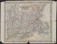
- Creator:
- G.W. & C.B. Colton & Co
- Published / Created:
- 1886
- Call Number:
- 76 1886
- Container / Volume:
- BRBL_00445
- Image Count:
- 1
- Resource Type:
- Maps, Atlases & Globes
- Found in:
- Beinecke Rare Book and Manuscript Library > Colton's railroad & township map of Massachusetts, Rhode Island and Connecticut : with parts of Maine, New Hampshire, Vermont & New York.
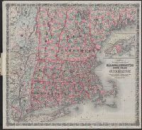
- Creator:
- J.H. Colton & Co
- Published / Created:
- 1853
- Call Number:
- 76gme 1853
- Container / Volume:
- BRBL_00446A
- Image Count:
- 1
- Resource Type:
- Maps, Atlases & Globes
- Found in:
- Beinecke Rare Book and Manuscript Library > Colton's railroad and township map of Massachusetts, Rhode Island, and Connecticut. / published by J.H. Colton, no. 86 Cedar St. New York. 1853.