Search
You Searched For
Search Results
- Published / Created:
- [1772?]
- Call Number:
- 23 1772B
- Container / Volume:
- BRBL_00018
- Image Count:
- 1
- Resource Type:
- Maps, Atlases & Globes
- Found in:
- Beinecke Rare Book and Manuscript Library > A map of the discoveries made by the Russians on the North West Coast of America. London, Printed for John Bowles ... & Carington ...
- Published / Created:
- 1771
- Call Number:
- 23 1771
- Container / Volume:
- BRBL_00018
- Image Count:
- 1
- Resource Type:
- Maps, Atlases & Globes
- Found in:
- Beinecke Rare Book and Manuscript Library > A map of the discoveries made by the Russians on the north west coast of America ... London, Printed for Carington Bowles ...
- Published / Created:
- [1761]
- Call Number:
- 23 1761
- Container / Volume:
- BRBL_00018
- Image Count:
- 1
- Resource Type:
- Maps, Atlases & Globes
- Found in:
- Beinecke Rare Book and Manuscript Library > A map of the discoveries made by the Russians on the north west coast of America. Published by the Royal Academy of Sciences at Petersburg.
- Creator:
- Münster, Sebastian, 1489-1552
- Published / Created:
- 1588?]
- Call Number:
- 70 1588
- Container / Volume:
- BRBL_00685
- Image Count:
- 2
- Resource Type:
- Maps, Atlases & Globes
- Found in:
- Beinecke Rare Book and Manuscript Library > Americae sive novi orbis, nova descriptio.
- Published / Created:
- [1795?]
- Call Number:
- 23 1795
- Container / Volume:
- BRBL_00019
- Image Count:
- 1
- Resource Type:
- Maps, Atlases & Globes
- Found in:
- Beinecke Rare Book and Manuscript Library > Bowles's new pocket map of the discoveries made by the Russians on the north west coast of America. Printed for the proprietors, Bowles & Carver ... London.
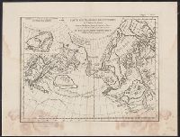
- Published / Created:
- 1772
- Call Number:
- 23 1772A
- Container / Volume:
- BRBL_00018
- Image Count:
- 1
- Resource Type:
- Maps, Atlases & Globes
- Found in:
- Beinecke Rare Book and Manuscript Library > Carte générale des découvertes de l'Amiral de Fonte ... par Thomas Jefferys, Géographe du roi à Londres, 1768. Cette carte a été traduite par M. de Vaugondy et gravée à Paris en 1772.
- Published / Created:
- 1752
- Call Number:
- 23 1752B
- Container / Volume:
- BRBL_00018
- Image Count:
- 1
- Resource Type:
- Maps, Atlases & Globes
- Found in:
- Beinecke Rare Book and Manuscript Library > Carte générale des découvertes de l'Amiral de Fonte, ... Par M. De L'Isle ...
- Published / Created:
- 1752
- Call Number:
- 23 1752A
- Container / Volume:
- BRBL_00018
- Image Count:
- 1
- Resource Type:
- Maps, Atlases & Globes
- Found in:
- Beinecke Rare Book and Manuscript Library > Carte générale des découvertes de l'Amiral de Fonte, ... Par M. De L'Isle ...
- Published / Created:
- [1795?]
- Call Number:
- 23 1795A
- Container / Volume:
- BRBL_00019
- Image Count:
- 1
- Resource Type:
- Maps, Atlases & Globes
- Found in:
- Beinecke Rare Book and Manuscript Library > Carte réduite de l'Ocean Septentrional compris entre l'Asie et l'Amérique ... par le Sr. Bellin, ingenieur ... cette carte est dressée sur les journaux des navigateurs Russes ... et autres memoires ... Par M. le Professeur Muller.
- Published / Created:
- 1766
- Call Number:
- 23 1766
- Container / Volume:
- BRBL_00018
- Image Count:
- 1
- Resource Type:
- Maps, Atlases & Globes
- Found in:
- Beinecke Rare Book and Manuscript Library > Carte réduite de l'océan septentrional compris entre l'Asie et l'Amérique ... Par le Sr. Bellin ...