Skip to search
Skip to main content
Skip to first result
Search
You Searched For
Genre
Maps
Subject (Geographic)
Washington (State)
Search Results
Published / Created:
undated
Call Number:
WA MSS S-2962
Collection Title:
Northern Pacific Railway Company maps and drawings
Container / Volume:
Box 1 | Map 11
Image Count:
1
Resource Type:
Maps, Atlases & Globes
Subject (Geographic):
Idaho and Washington (State)
Subject (Name):
Northern Pacific Railway Company
Subject (Topic):
Railroads
Found in:
Beinecke Rare Book and Manuscript Library > (IDAHO & WASHINGTON) [Anon.] [Untitled map of northwestern Idaho and northeastern Washington].
Creator:
Published / Created:
1890
Call Number:
WA MSS S-2962
Collection Title:
Northern Pacific Railway Company maps and drawings
Container / Volume:
Box 1 | Map 10
Image Count:
2
Resource Type:
Maps, Atlases & Globes
Description:
Distance 24-1/l0 Miles.
Subject (Geographic):
Clearwater River (Idaho), Nez Perce Indian Reservation (Idaho), Palouse River Valley (Idaho and Wash.), Snake River (Idaho), and Washington (State)
Subject (Name):
Northern Pacific Railway Company and Spokane and Palouse Railway Company
Subject (Topic):
Railroads--Right of way
Found in:
Beinecke Rare Book and Manuscript Library > (IDAHO) Kendrick, J. W., Surveyor. Map Showing Definite Location of the Spokane & Palouse Ry. (Lewiston Extension). From Julietta to Lewiston Idaho Territory. Distance 24-1/lO Miles. Drawn by J. M. Gibboney. Assistant Engineer's Office, Tacoma, Washington. Scale 1 in.=2000 ft.
Published / Created:
1891 September 10
Call Number:
WA MSS S-2962
Collection Title:
Northern Pacific Railway Company maps and drawings
Container / Volume:
Box 1 | Map 40
Image Count:
1
Resource Type:
Maps, Atlases & Globes
Description:
Scale 1 in. = 2780 ft. Map depicts the city of Spokane, all existing railroad lines, topographical detail, townships, smelters, etc.
Subject (Geographic):
Spokane (Wash.) and Washington (State)
Subject (Name):
Northern Pacific Railway Company
Subject (Topic):
Railroads
Found in:
Beinecke Rare Book and Manuscript Library > (WASHINGTON) [Anon.] Sketch of Country North of Spokane Wash. Helena Mont.
Published / Created:
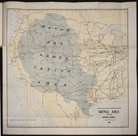
1884
Call Number:
Zc10 885up
Collection Title:
Range and ranch cattle
Image Count:
1
Resource Type:
Maps, Atlases & Globes
Description:
Verso blank.
Subject (Geographic):
Arizona, Colorado, Dakota Territory, Idaho, Kansas, Montana, Nebraska, Nevada, New Mexico, Oregon, Texas, Utah, Washington (State), and Wyoming
Subject (Name):
Nimmo, Joseph, 1837-1909
Subject (Topic):
Cattle --West (U.S.) and Ranches --West (U.S.)
Collection Created:
[Washington : Govt. Print. Off., 1885]
Found in:
Beinecke Rare Book and Manuscript Library > The range and ranch cattle area of the United States
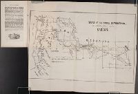
Creator:
Published / Created:
1851 March
Call Number:
Zc13 M6 So3d
Collection Title:
Rapport sur les missions du diocese de Quebec [microform]
Image Count:
1
Subject (Geographic):
Canada --Church history, Missouri, Oregon --Maps, Walla Walla (Wash.) --Maps, Walla Walla Valley (Or. and Wash.), Washington (State), and Westport (Kansas City, Mo.)
Subject (Topic):
Catholic Church --Missions, Indians of North America --Missions --Canada, Missions --Northwest, Pacific, Missions --Oregon, and Missions --Quebec (Province)
Collection Created:
Quebec : L. Brousseau, 1839-1874
Found in:
Beinecke Rare Book and Manuscript Library > Trace de la route de Westport, Etat de Missouri, a Walla Walla, Oregon
Branch:v1.68.2 ,Deployed:2025-06-12T06:59:30-04:00