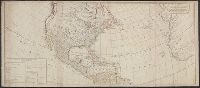
Includes table of "The continent and islands of America are divided and possessed as follows viz." and May be part of a map attributed to R. Sayer, based on maps by d'Anville and materials by Thomas Pownall; first issued in 1763 by J. Gibson and reissued over
Publisher:
s.n.,
Subject (Geographic):
America--Maps--Early works to 1800 and North America--Maps--Early works to 1800
Subject (Name):
Anville, Jean Baptiste Bourguignon d', 1697-1782, Gibson, J. (John), and Pownall, Thomas, 1722-1805
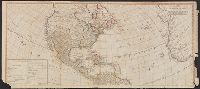
Includes table of "The continent and islands of America are divided and possessed as follows viz.", Prime meridian: Ferro., and Probably part of a map attributed to R. Sayer, based on maps by d'Anville and materials by Thomas Pownall; first issued in 1763 by J.
Publisher:
s.n.,
Subject (Geographic):
America--Maps--Early works to 1800 and North America--Maps--Early works to 1800
Subject (Name):
Anville, Jean Baptiste Bourguignon d', 1697-1782, Gibson, J. (John), and Pownall, Thomas, 1722-1805