Major Long's Expedition to the Rocky Mountains and Expedition to the Rocky Mountains
Description:
Spine title, on publisher's printed labels: Major Long's Expedition to the Rocky Mountains., Engravings by Young & Delleker, Cephas Grien Childs, Alexander Lawson, Francis Kearney, and William Hay; after Stephen H. Long, Samuel Seymour and Titian Ramsay Peale., Some maps on double leaves., Text and atlas in slipcase., BEIN: Bookplate of Joseph Y. Jeanes., GEO: Atlas wanting, no slipcase., and BAC: British Art Center copy complete with atlas. Bound in publisher's original tan boards. Inscribed: Maine Charity School from Mrs. Lord.
Publisher:
H.C. Carey and I. Lea, Chesnut St.
Subject (Geographic):
West (U.S.), Ohio River, Missouri River, and United States
Subject (Topic):
Discovery and exploration, Indians of North America, Languages, Geology, Discoveries in geography, and Glossaries, vocabularies, etc
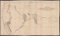
Map of an exploring expedition to the Rocky Mountains in the year 1842 and to Oregon and north California in the years 1843-44
Description:
Relief shown by hachures., State 3: Include notes, Great Basin statement, and place name South Park below Bayou Salade; some place names differ from other states., Cited in: Carl I. Wheat's Mapping the Transmississippi West, 1540-1861, vol. 2, no. 497; List of maps of America in the Library of Congress, page 642; Howes, W. U.S.iana, 1650-1950 (1962 edition), F370; and Library of Congress' Maps showing explorers' routes, trails & early roads in the United States, no. 223., and Includes "Profile of the route from the mouth of the Kansas to the Pacific by Capt. J.C. Fremont in 1843." Horizontal scale of profile: 1:3,000,000.
Publisher:
publisher not identified
Subject (Geographic):
West (U.S.) and Rocky Mountains Region
Subject (Topic):
Discoveries in geography, American, and Discovery and exploration
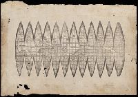
A photomechanical print probably created during the early twentieth century as a forgery that reproduces twelve gores for a globe published in 1507 by Martin Waldseemüller based on his wall map, Universalis Cosmographia (1507). and Evidence of the forgery includes the superimposition of the gores over glue already on the paper surface, which suggests use of a sheet removed from a period volume, as well as details that replicate gores from an authentic woodcut print formerly owned by Austrian cartographer Franz Hauslab and acquired by the James Ford Bell Library at the University of Minnesota in 1954
Description:
A gore is a roughly triangular or wedge-shaped segment of an object, as found in domes and globes, where a sector of a curved surface, or a curved surface that lies between two close lines of longitude on a globe, and flattened to a plane surface with little distortion., Martin Waldseemüller (1470-1519) was a German cartographer. His wall map Universalis Cosmographia (1507) and printed globes contemporarily derived from it were the first published globular maps of the Western Hemisphere and the first maps on which the name America appears in honor of Italian explorer Amerigo Vespucci (1454-1512)., In Latin., Title devised by cataloger., and Publication place and date of creation supplied by the cataloger.
Subject (Geographic):
America
Subject (Name):
Hauslab, Franz, 1798-1883., Vespucci, Amerigo, 1451-1512., and Waldseemüller, Martin, 1470-1519
Subject (Topic):
Forgeries, Globes, World maps, Discovery and exploration, and Name