Skip to search
Skip to main content
Skip to first result
Search
You Searched For
Date
-
"North America--Maps"
Genre
Maps
Subject (Topic)
Indians of North America--Oklahoma--Maps
New Search
Search Results
Published / Created:
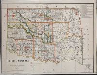
1889
Call Number:
827 1889
Container / Volume:
BRBL_00577
Image Count:
1
Resource Type:
Maps, Atlases & Globes
Description:
Relief shown by hachures. and Shows the lands occupied by various tribes and includes details about land transfers and cessions.
Publisher:
s.n.],
Subject (Geographic):
Oklahoma--Administrative and political divisions--Maps
Subject (Name):
A. Hoen & Co, Maxwell, Charles A, Olberg, John, and United States. Office of Indian Affairs
Subject (Topic):
Indians of North America --Oklahoma
Found in:
Beinecke Rare Book and Manuscript Library > Indian territory / compiled under the direction of the Hon. John H. Oberly, Commissioner of Indian Affairs, by C.A. Maxwell ; John Olberg, draftsman.
Creator:
Published / Created:
1844
Call Number:
796 1844A
Container / Volume:
BRBL_00524
Image Count:
1
Resource Type:
Maps, Atlases & Globes
Description:
Includes text and list of town popula, Prime meridians: Greenwich and Washington., Relief shown by hachures., and Shows Indian tribes and various routes, including "Pike's Route," "Long's Route," "Gregg's Route in 1840," and "Road to Santa Fé laid out in 1825."
Publisher:
War Dept.,
Subject (Geographic):
Southwestern States--Maps and Texas--Maps
Subject (Name):
Abert, John James, 1788-1863, United States. Army. Corps of Topographical Engineers, and United States. War Dept
Subject (Topic):
Indians of North America --Oklahoma
Found in:
Beinecke Rare Book and Manuscript Library > Map of Texas and the country adjacent / compiled in the Bureau of the Corps of Topographical Engeneers [sic], from the best authorities, for the State Department, under the direction of Col. J.J. Abert, Chief of the Corps, by W.H. Emory, 1st Lieut. T.E.
Creator:
Published / Created:
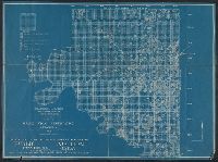
1911
Call Number:
827 Os1 1920
Container / Volume:
BRBL_00578
Image Count:
1
Resource Type:
Maps, Atlases & Globes
Publisher:
Office of Indian Affairs,
Subject (Geographic):
Osage County (Okla.)--Maps
Subject (Topic):
Indians of North America --Oklahoma
Found in:
Beinecke Rare Book and Manuscript Library > Map of Osage Indian Reservation, Oklahoma : 1911 / Department of the Interior, Office of Indian Affairs.
Branch:v1.61.6 ,Deployed:2024-06-12T09:55:36-04:00