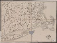
"Scale, Six Miles to the Inch.", Imperfect. Mutilated with loss of text., and Names counties and shows their boundaries. Shows only those populated places which are on rail lines. Covers southern Vermont and New Hampshire, Connecticut, Rhode Island, Long Island
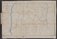
Covers areas of N.Y., Conn., and Mass. surrounding their intersection. and Includes ancillary "Profile of the Dutchess and Columbia and the proposed Connecticut Western Rail Road."
Publisher:
H.H. Lloyd & Co.'s Map Establishment,
Subject (Geographic):
Massachusetts--Maps
Subject (Name):
Connecticut Western Railroad Co.--Maps and Dutchess and Columbia Railroad Co.--Maps