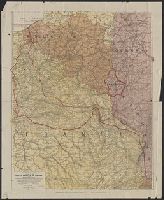
1. Rand McNally war map of the battle ground of liberty : the western battlefields of Europe, a Creator: Rand McNally and Company Published / Created: [1917?]. Call Number: 11hc 1917J Container / Volume: BRBL_00010D Image Count: 2 Resource Type: Maps, Atlases & Globes Found in: Beinecke Rare Book and Manuscript Library > Rand McNally war map of the battle ground of liberty : the western battlefields of Europe, a strategic map of the battle ground in Belgium and France from London, England to the Swiss border showing the farthest advance of the German armies, September 191
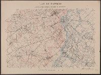
2. Camp de Lassigny, Anciennes Organisations Francaises et Allemandes [cartographic material Creator: Geological Survey (U.S.) Published / Created: 1917?] Call Number: 38hc L337 1917 Container / Volume: BRBL_00173 Image Count: 1 Resource Type: Maps, Atlases & Globes Found in: Beinecke Rare Book and Manuscript Library > Camp de Lassigny, Anciennes Organisations Francaises et Allemandes [cartographic material] / Engraved and printed by the U.S. Geological Survey.
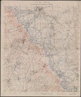
3. Camp de Lassigny, Anciennes Organisations Francaises et Allemandes [cartographic material]. Creator: Geological Survey (U.S.) Published / Created: 1916?] Call Number: 38hc L337 1916 Container / Volume: BRBL_00173 Image Count: 1 Resource Type: Maps, Atlases & Globes Found in: Beinecke Rare Book and Manuscript Library > Camp de Lassigny, Anciennes Organisations Francaises et Allemandes [cartographic material].
4. Carte des Frontières de l'Est : Théâtre de la Guerre 1914. Published / Created: 1914 Call Number: 11hc 1914S Image Count: 1 Resource Type: Maps, Atlases & Globes Found in: Beinecke Rare Book and Manuscript Library > Carte des Frontières de l'Est : Théâtre de la Guerre 1914.