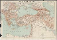
Map of Jugoslav territory and Map of Southern Slav territory
Description:
Imperfect: Cover wanting. Overprint in red on map indicating "Territory occupied by Italy 4000 S.q Mi.". Red stamp in upper right corner of sheet: "American Embassy. Paris, France Dec. 13, 1918"., Legend in English, Croatian, and French., and Sh
Publisher:
Christophers,
Subject (Geographic):
Yugoslavia--Maps and Yugoslavia--Maps--1915
Subject (Topic):
Ethnology--Yugoslavia--Maps and World War, 1914-1918--Maps
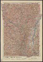
"Front au 1er. Janvier 1916.", "Supplément à l'illustration.", Ms. note outside bottom right margin "L'illus MY'19"., and Shows location of Western Front, railways, roads, canals, borders, and fortifications.
"Front au 1er. Janvier 1916.", "Supplément à l'illustration.", Ms. note outside bottom right margin "L'illus My'19"., and Shows location of Western Front, railways, roads, canals, borders, and fortifications.
Bumstead, Albert H. (Albert Hoit), 1875-1940 National Geographic Society (U.S.). Cartographic Division
Published / Created:
1918
Call Number:
30 1918B
Container / Volume:
BRBL_00032A
Image Count:
1
Resource Type:
Maps, Atlases & Globes
Alternative Title:
Index to the map of the Western Theatre of War.
Description:
Detached from: National Geographic, May 1918., Indexed by: Index to the map of the Western Theatre of War., and Inset: "Showing relation of the Western Theatre of War to the surrounding region and the connection of the two sections of the main map."
Publisher:
The Society,
Subject (Geographic):
Alsace (France)--Maps, Europe--Maps, and Lorraine (France)--Maps
Subject (Topic):
World War, 1914-1918--Belgium--Maps, World War, 1914-1918--France--Maps, and World War, 1914-1918--Maps
Bumstead, Albert H. (Albert Hoit), 1875-1940 National Geographic Society (U.S.). Cartographic Division
Published / Created:
1918
Call Number:
11hc 1918C
Container / Volume:
BRBL_00010E
Image Count:
1
Resource Type:
Maps, Atlases & Globes
Alternative Title:
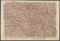
Index to the map of the Western Theatre of War.
Description:
Detached from: National Geographic, May 1918., Indexed by: Index to the map of the Western Theatre of War., and Inset: "Showing relation of the Western Theatre of War to the surrounding region and the connection of the two sections of the main map."
Publisher:
The Society,
Subject (Geographic):
Alsace (France)--Maps, Europe--Maps, and Lorraine (France)--Maps
Subject (Topic):
World War, 1914-1918--Belgium--Maps, World War, 1914-1918--France--Maps, and World War, 1914-1918--Maps
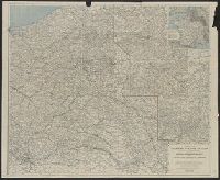
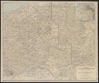
Area: from Baltic Sea to Innsbruck ; from Luxemburg to Warsaw., Imperfect. Cover wanting, some text lost., Includes index., and Shows: camps and hospitals for British prisoners, towns, rivers and roads.
Publisher:
Nisbet & Co.,
Subject (Geographic):
Austria--Maps and Germany--Maps
Subject (Topic):
World War, 1914-1918--Maps and World War, 1914-1918--Prisoners and prisons, German--Maps
Royal Geographical Society (Great Britain). Geographical Section, cartographer
Call Number:
11hcf 1919E-23
Container / Volume:
BRBL_00010ZA
Image Count:
1
Resource Type:
Maps, Atlases & Globes
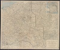
Alternative Title:
Europe 1:1,000,000, G.S.G.S. ; no. 2758, and GSGS (Series) ; no. 2758.
Description:
Elevation shown by color., Includes index to adjoining sheets, index to boundaries, and pronunciation glossary., and Sheet "North L-33, Triest," from same series, attached. Label pasted at foot of sheet showing "Treaty of London line" and "Recommended southern