Search
You Searched For
Search Results
- Published / Created:
- [1891]
- Call Number:
- WA MSS S-1404
- Collection Title:
- James W. Forsyth papers
- Container / Volume:
- 11 (Oversize) | Folder 193
- Image Count:
- 2
- Resource Type:
- Archives or Manuscripts
- Found in:
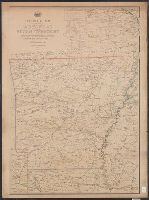
- Beinecke Rare Book and Manuscript Library > Scene of the fight with Big Foot's Band, December 29th, 1890, showing the position of the troops when first shot was fired. From sketches by Lt. S. A. Cloman, Acting Engineer Officer, Division of the Missouri (printed map)
- Creator:
- Nicholson, W. L
- Published / Created:
- 1881?]
- Call Number:
- 818 1881
- Container / Volume:
- BRBL_00565
- Image Count:
- 2
- Resource Type:
- Maps, Atlases & Globes
- Found in:
- Beinecke Rare Book and Manuscript Library > Post route map of the state of Arkansas and of the Indian Territory : with adjacent portions of Mississippi, Tennessee, Missouri, Kansas, Texas and Louisiana / designed and constructed under the orders of Postmaster General D.M. Key, by W.L. Nicholson, to
- Creator:
- James, Edwin, 1797-1861
- Call Number:
- Zc20 +822ja
- Image Count:
- 41
- Resource Type:
- Maps, Atlases & Globes
- Subject (Geographic):
- Missouri River--Discovery and
- Found in:
- Beinecke Rare Book and Manuscript Library > Account of an expedition from Pittsburgh to the Rocky Mountains : performed in the years 1819 and '20, by order of the Hon. J.C. Calhoun, Sec'y of War ; under the command of Major Stephen H. Long : from the notes of Major Long, Mr. T. Say, and other gentlemen of the exploring party / compiled by Edwin James, botanist and geologist for the expedition ; in two vols., with an atlas.
- Creator:
- Pike, Zebulon Montgomery, 1779-1813
- Published / Created:
- 1810
- Call Number:
- GA405 +W44 (LC)
- Collection Title:
- Mapping the transmississippi West, 1540-1861
- Image Count:
- 1
- Found in:
- Beinecke Rare Book and Manuscript Library > A Chart of the Internal Part of Louisiana, Including all the hitherto unexplored Countries, lying between the River La Platte of the Missouri on the N: and the Red River on the S: the Mississippi East and the Mountains of Mexico West; with a Part of New M
- Creator:
- Cramer, Zadok, 1773-1813. Navigator
- Call Number:
- Zc20 822cui
- Collection Title:
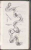
- the Missouri to the Gulf of Mexico : accompanied with directions for navigating the same, and a
- Image Count:
- 1
- Found in:
- Beinecke Rare Book and Manuscript Library > Mississippi
- Creator:
- Cramer, Zadok, 1773-1813. Navigator
- Call Number:
- Zc20 822cui
- Collection Title:
- the Missouri to the Gulf of Mexico : accompanied with directions for navigating the same, and a
- Image Count:
- 1
- Found in:
- Beinecke Rare Book and Manuscript Library > Mississippi
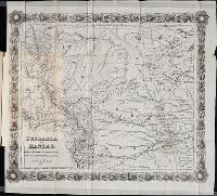
- Published / Created:
- 1859
- Call Number:
- Zc10 859re
- Collection Title:
- southern--from the Missouri River to the gold region; the guide giving a description of the country, game
- Image Count:
- 1
- Resource Type:
- Maps, Atlases & Globes
- Found in:
- Beinecke Rare Book and Manuscript Library > Nebraska and Kanzas. Showing Pikes Peak and the gold region