Search
You Searched For
Search Results
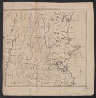
- Published / Created:
- [1831?]
- Call Number:
- 764 B63 1831
- Container / Volume:
- BRBL_00454
- Image Count:
- 1
- Resource Type:
- Maps, Atlases & Globes
- Found in:
- Beinecke Rare Book and Manuscript Library > A Map of the Town of Bolton in the County of Worcester and the Commonwealth of Massachusetts. Surveyed by Silas Holman in the Year 1831.
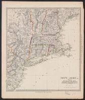
- Published / Created:
- [1839]
- Call Number:
- 76 1839
- Container / Volume:
- BRBL_00444
- Image Count:
- 4
- Resource Type:
- Maps, Atlases & Globes
- Found in:
- Beinecke Rare Book and Manuscript Library > Map of Maine, New Hampshire, Vermont, Massachusetts, Rhode Island and Connecticut. Exhibiting the Post Offices, Post Roads, Canals, Rail Roads, &c. by David H. Burr ...
- Creator:
- Society for the Diffusion of Useful Knowledge (Great Britain)
- Published / Created:
- 1832
- Call Number:
- 755 1832A
- Container / Volume:
- BRBL_00440
- Image Count:
- 1
- Resource Type:
- Maps, Atlases & Globes
- Found in:
- Beinecke Rare Book and Manuscript Library > North America. Sheet VI, New-York, Vermont, Maine, New-Hampshire, Massachusetts, Connecticut, Rhode-Island, and New-Jersey / published by the Society for the Diffusion of Useful Knowledge.
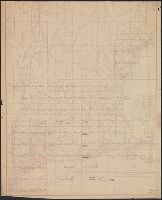
- Published / Created:
- 1849
- Call Number:
- 76BF 1849T
- Container / Volume:
- BRBL_00446
- Image Count:
- 1
- Resource Type:
- Maps, Atlases & Globes
- Found in:
- Beinecke Rare Book and Manuscript Library > Sketch A, showing the process in section no. 1, U.S. Coast Survey in 1844, '45, '46, '47, '48, & '49. [Coast of Rhode Island, Massachusetts, New Hampshire, and Maine]
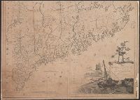
- Published / Created:
- 1775]
- Call Number:
- 76 1740
- Container / Volume:
- BRBL_00690
- Image Count:
- 1
- Resource Type:
- Maps, Atlases & Globes
- Subject (Geographic):
- Massachusetts--Maps--Early works to
- Found in:
- Beinecke Rare Book and Manuscript Library > A map of 100 miles round Boston [cartographic material].
- Published / Created:
- [1801]
- Call Number:
- 761 1801
- Container / Volume:
- BRBL_00447
- Image Count:
- 2
- Resource Type:
- Maps, Atlases & Globes
- Found in:
- Beinecke Rare Book and Manuscript Library > Map of the district of Maine, Massachusetts, compiled from actual surveys made by order of the General Court, and under the inspection of agents of their appointment, by Osgood Carleton.
- Creator:
- Nicholson, Walter L
- Published / Created:
- 19--?].
- Call Number:
- 76GMD 1866
- Container / Volume:
- BRBL_00446A
- Image Count:
- 1
- Resource Type:
- Maps, Atlases & Globes
- Subject (Topic):
- Postal service--Massachusetts--Maps
- Found in:
- Beinecke Rare Book and Manuscript Library > Post route map [of the states of] New Hampshire, Vermont, Massachusetts, Rhode Island, Connecticut, and parts of New York and Maine / designed and constructed under the orders of Postmaster General Wm. Dennison and Second Ass't Postmaster Gen'l Geo. Wm. M
- Creator:
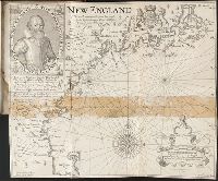
- Smith, John, 1580-1631
- Published / Created:
- 1631
- Call Number:
- Taylor 316
- Image Count:
- 2
- Subject (Geographic):
- Massachusetts--History--Colonial period
- Found in:
- Beinecke Rare Book and Manuscript Library > Advertisements for the unexperienced planters of New-England, or anywhere, or, The path-way to experience to erect a plantation : With the yearely proceedings of this country in fishing and planting, since the yeare 1614. to the yeare 1630. and their present estate. Also how to prevent the greatest inconveniences, by their proceedings in Virginia, and other plantations, by approved examples. With the countries armes, a description of the coast, harbours, habitations, land-markes, latitude and longitude: with the map, allowed by our royall King Charles. By Captaine Iohn Smith, sometimes governour of Virginia, and admirall of Nevv-England.
- Creator:
- Eddy, J.
Lowe, George, fl. 1613?-ca. 1615?
- Published / Created:
- 1614-16
- Call Number:
- Zd 176
- Collection Title:
- Path-way to experience to erect a plantation
- Image Count:
- 1
- Subject (Geographic):
- Massachusetts --History --Colonial
- Found in:
- Beinecke Rare Book and Manuscript Library > New England: the most remarqueable parts thus named by the high and mighty Prince Charles, Prince of Great Britaine