Search
You Searched For
Search Results
- Creator:
- Jefferys, Thomas, d. 1771
- Published / Created:
- 1st January 1789.
- Call Number:
- 655 1789
- Container / Volume:
- BRBL_00345
- Image Count:
- 1
- Resource Type:
- Maps, Atlases & Globes
- Subject (Geographic):
- Africa, West--Maps--Early works to 1800
- Subject (Topic):
- Coasts--Africa, West--Maps--Early works
- Found in:
- Beinecke Rare Book and Manuscript Library > The western coast of Africa, from Cape Blanco to Cape Virga, exhibiting Senegambia proper / by T. Jefferys.
- Creator:
- Linschoten, Jan Huygen van, 1563-1611
- Published / Created:
- 1596]
- Call Number:
- 64 1596
- Container / Volume:
- BRBL_00337
- Image Count:
- 1
- Resource Type:
- Maps, Atlases & Globes
- Subject (Geographic):
- Africa, Southern--Maps--Early works to
- Subject (Topic):
- Coasts--Africa, Southern--Maps--Early
- Found in:
- Beinecke Rare Book and Manuscript Library > Typus orarum maritimarum Guineae, Manicongo, & Angôlae ultra promontorium Bonae Spei ... [cartographic material] = Afheeldinghe der custen des landts Guinea, Manicongo, ende Angôla, ende voorts tot voorby de C. de boa esperança ... / Arnoldus F. á Lan
- Creator:
- L'Isle, Guillaume de, 1675-1726
- Published / Created:
- 1720?]
- Call Number:
- 49 1740
- Container / Volume:
- BRBL_00684
- Image Count:
- 1
- Resource Type:
- Maps, Atlases & Globes
- Subject (Topic):
- --Maps--Early works to 1800
- Found in:
- Beinecke Rare Book and Manuscript Library > In notitiam ecclesiasticam Africae tabula geographica / auctore G. De L'Isle ...
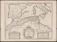
- Creator:
- L'Isle, Guillaume de, 1675-1726
- Published / Created:
- 1780
- Call Number:
- 49 1780
- Container / Volume:
- BRBL_00267
- Image Count:
- 1
- Resource Type:
- Maps, Atlases & Globes
- Subject (Topic):
- --Maps--Early works to 1800
- Found in:
- Beinecke Rare Book and Manuscript Library > In notitiam ecclesiasticam Africæ tabula geographica [cartographic material] / Auctore G. de l'Isle ; Joan. Bap. Liébaux inv. et sculp.
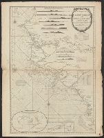
- Published / Created:
- 1792
- Call Number:
- 60cea 1792
- Container / Volume:
- BRBL_00329
- Image Count:
- 1
- Resource Type:
- Maps, Atlases & Globes
- Subject (Geographic):
- Africa--Maps--Early works to 1800
- Found in:
- Beinecke Rare Book and Manuscript Library > A new Survey of the Coast of Africa from Senegal and Cape Verd to Cape St. Ann ...
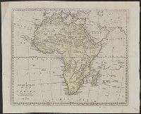
- Creator:
- Bowen, Thomas, d. 1790
- Published / Created:
- 1794?]
- Call Number:
- 60 1794B
- Container / Volume:
- BRBL_00324
- Image Count:
- 1
- Resource Type:
- Maps, Atlases & Globes
- Subject (Geographic):
- Africa--Maps--Early works to 1800
- Found in:
- Beinecke Rare Book and Manuscript Library > A new and accurate map of Africa, drawn from the best authorities / by Thos. Bowen.
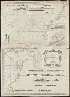
- Published / Created:
- 1794
- Call Number:
- 60cea 1794
- Container / Volume:
- BRBL_00329
- Image Count:
- 1
- Resource Type:
- Maps, Atlases & Globes
- Subject (Geographic):
- Africa--Maps--Early works to 1800
- Found in:
- Beinecke Rare Book and Manuscript Library > A new chart of the Coast of Africa from the Straits of Gibralter to Cape Blanco with Madeira & the Canary Islands ...
- Creator:
- Senex, John, d. 1740
- Published / Created:
- 1721]
- Call Number:
- 60 1721
- Container / Volume:
- BRBL_00322
- Image Count:
- 1
- Resource Type:
- Maps, Atlases & Globes
- Subject (Geographic):
- Africa--Maps--Early works to 1800
- Found in:
- Beinecke Rare Book and Manuscript Library > A new map of Africa, from the latest observations.
- Published / Created:
- 1700?]
- Call Number:
- 60 1700
- Container / Volume:
- BRBL_00322
- Image Count:
- 1
- Resource Type:
- Maps, Atlases & Globes
- Subject (Geographic):
- Africa--Maps--Early works to 1800
- Found in:
- Beinecke Rare Book and Manuscript Library > A new map of Africk : shewing its present general divisions, cheif cities or towns, rivers, mountains &c.