Search
You Searched For
Search Results
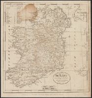
- Published / Created:
- 1795
- Call Number:
- 327 1795B
- Container / Volume:
- BRBL_00072
- Image Count:
- 1
- Resource Type:
- Maps, Atlases & Globes
- Found in:
- Beinecke Rare Book and Manuscript Library > A Map of Ireland according to the best authorities.
- Published / Created:
- [1798?]
- Call Number:
- 327 1798
- Container / Volume:
- BRBL_00073
- Image Count:
- 1
- Resource Type:
- Maps, Atlases & Globes
- Found in:
- Beinecke Rare Book and Manuscript Library > A Map of Ireland according to the best authorities. Engraved for Plowden's Historical Review of the State of Ireland.
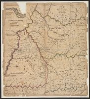
- Published / Created:
- [1793?]
- Call Number:
- 802 1793
- Container / Volume:
- BRBL_00542
- Image Count:
- 1
- Resource Type:
- Maps, Atlases & Globes
- Found in:
- Beinecke Rare Book and Manuscript Library > A Map of Kentucky, Drawn from Actual Observations. By John Filson.
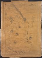
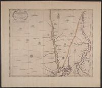
- Published / Created:
- 1831
- Call Number:
- 764 M52 1831
- Container / Volume:
- BRBL_00458
- Image Count:
- 1
- Resource Type:
- Maps, Atlases & Globes
- Found in:
- Beinecke Rare Book and Manuscript Library > A Map of Mendon, Worcester County, Mass. By John Geo. Metcalf, M.D. Newell nelson, Surveyor.
- Creator:
- Tanner, Henry Schenck, 1786-1858
- Published / Created:
- 1822
- Call Number:
- 2003 Folio 81
- Collection Title:
- The New American Atlas ...
- Container / Volume:
- No. IV [4]
- Image Count:
- 1
- Found in:
- Beinecke Rare Book and Manuscript Library > A Map of North America, Constructed According to the Latest Information by H. S. Tanner
- Published / Created:
- [1681]
- Call Number:
- 774 1681
- Container / Volume:
- BRBL_00497
- Image Count:
- 3
- Resource Type:
- Maps, Atlases & Globes
- Found in:
- Beinecke Rare Book and Manuscript Library > A Map of Some of the South and east bounds of Pennsylvania in America ... Sold by John Thornton ... and by John Seller ... London.
- Published / Created:
- [1795]
- Call Number:
- 90 1795A
- Container / Volume:
- BRBL_00661
- Image Count:
- 1
- Resource Type:
- Maps, Atlases & Globes
- Found in:
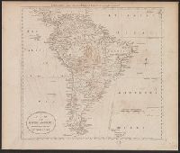
- Beinecke Rare Book and Manuscript Library > A Map of South America According to the best Authorities.
- Published / Created:
- [1834?]
- Call Number:
- 764 SP33 1834
- Container / Volume:
- BRBL_00459
- Image Count:
- 1
- Resource Type:
- Maps, Atlases & Globes
- Found in:
- Beinecke Rare Book and Manuscript Library > A Map of Spencer, Mass. ... by William Baldwin. 1834.
- Published / Created:
- 1755
- Call Number:
- 32 Sa25 1755
- Container / Volume:
- BRBL_00054
- Image Count:
- 1
- Resource Type:
- Maps, Atlases & Globes
- Found in:
- Beinecke Rare Book and Manuscript Library > A Map of St. Sepulchers without Charterhouse Liberty and Clarken Well Parish ... for Ston's Survey.
- Published / Created:
- 1755
- Call Number:
- 771ad Al13 1755
- Container / Volume:
- BRBL_00714
- Image Count:
- 1
- Resource Type:
- Maps, Atlases & Globes
- Found in:
- Beinecke Rare Book and Manuscript Library > A Map of a Tract of 13,000 Acres of Land in the County of Albany on the West Side of Canyadarge Lake granted to David Schuyler and others the 3 June 1755 ... Thomas Palmer, Surv.
- Published / Created:
- [1775?]
- Call Number:
- 76cea 1775
- Container / Volume:
- BRBL_00446
- Image Count:
- 1
- Resource Type:
- Maps, Atlases & Globes
- Found in:
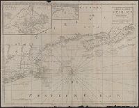
- Beinecke Rare Book and Manuscript Library > A Map of the Coast of New England from Staten Island of Breton; as if was actualy survey'd by Capt. Cyprian Southback.
- Published / Created:
- [1775?]
- Call Number:
- 76cea 1775A
- Container / Volume:
- BRBL_00446
- Image Count:
- 1
- Resource Type:
- Maps, Atlases & Globes
- Found in:
- Beinecke Rare Book and Manuscript Library > A Map of the Coast of New England from Staten Island to the Island of Breton; as it was actualy survey'd by Capt Cyprian Southback.
- Published / Created:
- 1798]
- Call Number:
- 8045 1798B
- Container / Volume:
- BRBL_00546
- Image Count:
- 1
- Resource Type:
- Maps, Atlases & Globes
- Found in:
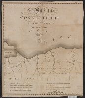
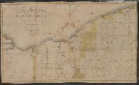
- Beinecke Rare Book and Manuscript Library > A Map of the Connecticut Western Reserve, from actual Survey, By Seath Pease.
- Published / Created:
- 1798
- Call Number:
- 8045 1798A
- Container / Volume:
- BRBL_00546
- Image Count:
- 1
- Resource Type:
- Maps, Atlases & Globes
- Found in:
- Beinecke Rare Book and Manuscript Library > A Map of the Connecticut Western Reserve, from actual Survey, by Seth Pease & Abn. Tappen.
- Published / Created:
- 1704
- Call Number:
- Cxb e678ge
- Collection Title:
- The history of the bucaniers of America : from the first original down to this time; written in
- Image Count:
- 1
- Resource Type:
- Maps, Atlases & Globes
- Found in:
- Beinecke Rare Book and Manuscript Library > A Map of the Countrey and Citty of Panama. Part 3: Chap: 5.
- Published / Created:
- 1795]
- Call Number:
- 18 1795A
- Container / Volume:
- BRBL_00012
- Image Count:
- 1
- Resource Type:
- Maps, Atlases & Globes
- Found in:
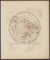
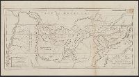
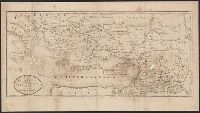
- Beinecke Rare Book and Manuscript Library > A Map of the Countries situate about the North Pole as far as the 50th Degree of North Latitude. W. Barker, sculp.
- Published / Created:
- 1795]
- Call Number:
- 18 1795
- Container / Volume:
- BRBL_00012
- Image Count:
- 1
- Resource Type:
- Maps, Atlases & Globes
- Found in:
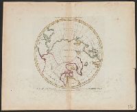
- Beinecke Rare Book and Manuscript Library > A Map of the Countries situate about the North Pole as far as the 50th Degree of North Latitude. W. Barker, sculp.
- Published / Created:
- [1770?]
- Call Number:
- 771ad C38 1770
- Container / Volume:
- BRBL_00714
- Image Count:
- 1
- Resource Type:
- Maps, Atlases & Globes
- Found in:
- Beinecke Rare Book and Manuscript Library > A Map of the County of Charlotte.
- Published / Created:
- 1866
- Call Number:
- 304 1866
- Container / Volume:
- BRBL_00033
- Image Count:
- 1
- Resource Type:
- Maps, Atlases & Globes
- Found in:
- Beinecke Rare Book and Manuscript Library > A Map of the Germanic Confederation as it existed in June, 1866 and of Central Europe.
- Creator:
- Stockdale, John, 1749?-1814
- Published / Created:
- 1800 Nov. 24
- Call Number:
- CF1921 E38 1801
- Collection Title:
- An historical survey of the island of Saint Domingo, together with an account of the Maroon negroes
- Image Count:
- 1
- Resource Type:
- Maps, Atlases & Globes
- Found in:
- Beinecke Rare Book and Manuscript Library > A Map of the Island of St. Domingo
- Published / Created:
- 1768
- Call Number:
- 771 Al13 1768
- Container / Volume:
- BRBL_00713
- Image Count:
- 2
- Resource Type:
- Maps, Atlases & Globes
- Found in:
- Beinecke Rare Book and Manuscript Library > A Map of the Lands Adjoining the Partition Line between Countys of Albany & Ulster Done of New York, 1768, Will Cockburn.
- Published / Created:
- 1765
- Call Number:
- 771 Al13 1765
- Container / Volume:
- BRBL_00713
- Image Count:
- 2
- Resource Type:
- Maps, Atlases & Globes
- Found in:
- Beinecke Rare Book and Manuscript Library > A Map of the Lands on the Southside of the County of Albany between the Blue Mountains and the Sawkill. Surred in the month of Oct. 1765, by Will Cockburn.
- Published / Created:
- [1785?]
- Call Number:
- 755 1785F
- Container / Volume:
- BRBL_00435
- Image Count:
- 1
- Resource Type:
- Maps, Atlases & Globes
- Found in:
- Beinecke Rare Book and Manuscript Library > A Map of the North West parts of the United States of America ... [by] John Fitch ...
- Published / Created:
- [1790?]
- Call Number:
- 32 1790
- Container / Volume:
- BRBL_00044
- Image Count:
- 1
- Resource Type:
- Maps, Atlases & Globes
- Found in:
- Beinecke Rare Book and Manuscript Library > A Map of the Roads of England and Wales.
- Published / Created:
- [1795]
- Call Number:
- 801 1795
- Container / Volume:
- BRBL_00541
- Image Count:
- 1
- Resource Type:
- Maps, Atlases & Globes
- Found in:
- Beinecke Rare Book and Manuscript Library > A Map of the Tennassee State formerly Part of North Carolina taken Chiefly from Survey by Genl. Smith & others.
- Published / Created:
- [1831?]
- Call Number:
- 764 B63 1831
- Container / Volume:
- BRBL_00454
- Image Count:
- 1
- Resource Type:
- Maps, Atlases & Globes
- Found in:
- Beinecke Rare Book and Manuscript Library > A Map of the Town of Bolton in the County of Worcester and the Commonwealth of Massachusetts. Surveyed by Silas Holman in the Year 1831.
- Published / Created:
- 1783
- Call Number:
- Cb21 35B
- Collection Title:
- History of the war with America, France, Spain, and Holland; commencing in 1775 and ending in 1783
- Image Count:
- 1
- Found in:
- Beinecke Rare Book and Manuscript Library > A Map of the United States of America, as settled by the peace of 1783
- Published / Created:
- 1809
- Call Number:
- 755 1809A
- Container / Volume:
- BRBL_00438
- Image Count:
- 1
- Resource Type:
- Maps, Atlases & Globes
- Found in:
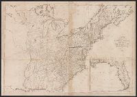
- Beinecke Rare Book and Manuscript Library > A Map of the United States: compiled chiefly from the State Maps, and other Authentic Information, by Saml. Lewis.
- Published / Created:
- 1795
- Call Number:
- 11 1795
- Container / Volume:
- BRBL_00006
- Image Count:
- 1
- Resource Type:
- Maps, Atlases & Globes
- Found in:
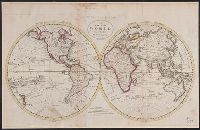
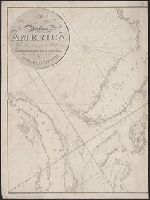
- Beinecke Rare Book and Manuscript Library > A Map of the World from the best Authorities.
- Call Number:
- Zd 147
- Collection Title:
- The history of the Five Indian nations of Canada : which are dependent on the province of New-York
- Image Count:
- 1
- Found in:
- Beinecke Rare Book and Manuscript Library > A Map of the country of the Five Nations, belonging to the province of New York; and of the lakes near which the nations of far Indians live, with part of Canada
- Published / Created:
- 1757
- Call Number:
- 36hc P88 1756
- Container / Volume:
- BRBL_00134
- Image Count:
- 1
- Resource Type:
- Maps, Atlases & Globes
- Found in:
- Beinecke Rare Book and Manuscript Library > A Map of the country round Prague ... : A Plan of the city of Prague ...
- Creator:
- J. F. L
- Call Number:
- 1998 2141
- Collection Title:
- Der ausfuehrlichen nachrichten von der koeniglich-gross-britannischen colonie saltzburgischer
- Image Count:
- 1
- Found in:
- Beinecke Rare Book and Manuscript Library > A Map of the county of Savannah
- Published / Created:
- [1774]
- Call Number:
- 76 1774
- Container / Volume:
- BRBL_00729
- Image Count:
- 1
- Resource Type:
- Maps, Atlases & Globes
- Found in:
- Beinecke Rare Book and Manuscript Library > A Map of the most inhabited part of New England [cartographic material] : containing the provinces of Massachusets Bay and New Hampshire with the colonies of Conecticut and Rhode Island divided into counties and townships : The whole composed from actual
- Published / Created:
- [1774]
- Call Number:
- 76 1774
- Container / Volume:
- BRBL_00729
- Image Count:
- 2
- Resource Type:
- Maps, Atlases & Globes
- Found in:
- Beinecke Rare Book and Manuscript Library > A Map of the most inhabited part of New England [cartographic material] : containing the provinces of Massachusets Bay and New Hampshire with the colonies of Conecticut and Rhode Island divided into counties and townships : The whole composed from actual
- Published / Created:
- [1774]
- Call Number:
- 76 1774
- Container / Volume:
- BRBL_00443
- Image Count:
- 2
- Resource Type:
- Maps, Atlases & Globes
- Found in:
- Beinecke Rare Book and Manuscript Library > A Map of the most inhabited part of New England [cartographic material] : containing the provinces of Massachusets Bay and New Hampshire with the colonies of Conecticut and Rhode Island divided into counties and townships : The whole composed from actual
- Call Number:
- Egf 789
- Collection Title:
- The American geography; or, A view of the present situation of the United States of America
- Image Count:
- 1
- Found in:
- Beinecke Rare Book and Manuscript Library > A Map of the northern and middle states; comprehending the western Territory and the British dominions in North America. Compiled from the best authorities
- Creator:
- Doolittle, Amos, 1754-1832
Purcell, Joseph
- Published / Created:
- 1788
- Call Number:
- Egf 789
- Collection Title:
- The American geography; or, A view of the present situation of the United States of America
- Image Count:
- 1
- Found in:
- Beinecke Rare Book and Manuscript Library > A Map of the states of Virginia, North Carolina South Carolina and Georgia comprehending the Spanish provinces of east and west Florida exhibiting the boundaries as fixed by the late Treaty of Peace between the United States and the Spanish dominions comp
- Call Number:
- Taylor 376
- Collection Title:
- The discoveries of John Lederer : in three several marches from Virginia, to the west of Carolina
- Image Count:
- 1
- Found in:
- Beinecke Rare Book and Manuscript Library > A Map of the whole territory traversed by John Lederer in his three marches
- Published / Created:
- 1719
- Call Number:
- Defoe 50 719db 1
- Collection Title:
- The life and strange surprizing adventures of Robinson Crusoe, of York, mariner : who lived eight
- Image Count:
- 1
- Resource Type:
- Maps, Atlases & Globes
- Found in:
- Beinecke Rare Book and Manuscript Library > A Map of the world, on wch is delineated the voyages of Robinson Cruso
- Published / Created:
- [1795?]
- Call Number:
- 51 50 A.D.
- Container / Volume:
- BRBL_00280
- Image Count:
- 1
- Resource Type:
- Maps, Atlases & Globes
- Found in:
- Beinecke Rare Book and Manuscript Library > A Map of those Countries in which the Apostles Travelled: in propagating Christianity. Compiled and Engraved by Joseph T. Scott.
- Published / Created:
- 1797
- Call Number:
- 771 N49 1797
- Container / Volume:
- BRBL_00484
- Image Count:
- 1
- Resource Type:
- Maps, Atlases & Globes
- Found in:
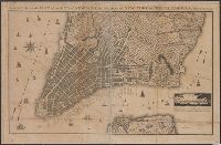
- Beinecke Rare Book and Manuscript Library > A New & Accurate Plan of the City of New York in the State of New York in North America. Published in 1797.
- Published / Created:
- [1790?]
- Call Number:
- 3191 1790A
- Container / Volume:
- BRBL_00041
- Image Count:
- 1
- Resource Type:
- Maps, Atlases & Globes
- Found in:
- Beinecke Rare Book and Manuscript Library > A New & Correct Map of Six Hundred Miles around London, with the Roads & Post Miles in England, Ireland & Scotland, and the Post Leagues in France.
- Published / Created:
- [1780]
- Call Number:
- 32 L84 1780
- Container / Volume:
- BRBL_00048
- Image Count:
- 1
- Resource Type:
- Maps, Atlases & Globes
- Found in:
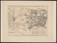
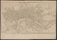
- Beinecke Rare Book and Manuscript Library > A New & Correct Plan of the Cities of London and Westminister, with the Borough of Southwark ...
- Published / Created:
- 1818
- Call Number:
- 755cea 1818
- Container / Volume:
- BRBL_00442
- Image Count:
- 4
- Resource Type:
- Maps, Atlases & Globes
- Found in:
- Beinecke Rare Book and Manuscript Library > A New Chart of America, by Robt. Blachford. To His Excellency James Monroe ...
- Published / Created:
- [1821?]
- Call Number:
- 7645cea 1821
- Container / Volume:
- BRBL_00463
- Image Count:
- 1
- Resource Type:
- Maps, Atlases & Globes
- Found in:
- Beinecke Rare Book and Manuscript Library > A New Chart of Nantucket Shoals & George's Bank with the adjacent coast drawn from the latest authorities. 2nd Edition. By Samuel Lambert. Salem. Cushing, Appleton & S. Lambert, of the State of Mass. Corrected June 1821.
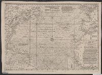
- Published / Created:
- 1755
- Call Number:
- 21 1755
- Container / Volume:
- BRBL_00014
- Image Count:
- 1
- Resource Type:
- Maps, Atlases & Globes
- Found in:
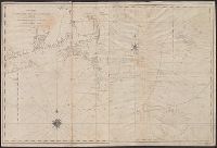
- Beinecke Rare Book and Manuscript Library > A New Chart of the Vast Atlantic Ocean; Exhibiting the Seat of War, both in Europe and America ...
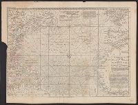
- Published / Created:
- 1755
- Call Number:
- 21 1755
- Container / Volume:
- BRBL_00014
- Image Count:
- 1
- Resource Type:
- Maps, Atlases & Globes
- Found in:
- Beinecke Rare Book and Manuscript Library > A New Chart of the Vast Atlantic Ocean; Exhibiting the Seat of War, both in Europe and America ...
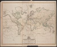
- Published / Created:
- 1794
- Call Number:
- 11 1794A
- Container / Volume:
- BRBL_00006
- Image Count:
- 1
- Resource Type:
- Maps, Atlases & Globes
- Found in:
- Beinecke Rare Book and Manuscript Library > A New Chart of the World ... with the tracks of the British Circumnavigators Bryon, Wallis, Carteret and Cook, &c.