Search
You Searched For
Search Results
- Creator:
- George B. Cadwell & Co
- Published / Created:
- 1892
- Call Number:
- 811 T227 1892
- Container / Volume:
- BRBL_00553
- Image Count:
- 1
- Resource Type:
- Maps, Atlases & Globes
- Subject (Name):
- Lenawaee County, Michigan
- Subject (Topic):
- Real property--Michigan--Tecumseh--Maps
- Found in:
- Beinecke Rare Book and Manuscript Library > Map of Tecumseh : compiled for Geo. B. Cadwell & Co's. atlas of Lenawee County, Mich.
- Published / Created:
- 1858
- Call Number:
- 811cea Sa245 1858B
- Container / Volume:
- BRBL_00554
- Image Count:
- 1
- Resource Type:
- Maps, Atlases & Globes
- Subject (Geographic):
- Michigan--Maps
- Found in:
- Beinecke Rare Book and Manuscript Library > Tracing of field chart of West Channel of East Neebish rapids : surveyed for the use of the St. Mary's River improvement under the orders of Capt. A.W. Whipple, T.E. / by J.H. Foster U.S. Sub. Agt. May 1858.
- Published / Created:
- 1858
- Call Number:
- 811cea Sa245 1858A
- Container / Volume:
- BRBL_00554
- Image Count:
- 1
- Resource Type:
- Maps, Atlases & Globes
- Subject (Geographic):
- Michigan--Maps
- Found in:
- Beinecke Rare Book and Manuscript Library > Chart of East Neebish rapids, River St. Mary : showing the improved west channel, dredged and surveyed in 1858 under the direction of Capt. A.W. Whipple, T.E. / J.H. Foster U.S. Sub. Agt., James T. Foster, draughtsman.
- Published / Created:
- 1858
- Call Number:
- 811cea Sa245 1858
- Container / Volume:
- BRBL_00554
- Image Count:
- 1
- Resource Type:
- Maps, Atlases & Globes
- Subject (Geographic):
- Michigan--Maps
- Found in:
- Beinecke Rare Book and Manuscript Library > Channel cut of Middle Channel, Lake George : St. Mary's River improvement showing character of bottom & extent of dredging up to September 30th 1858 / drawn by James T. Baker, surveyed under the orders of Capt. A.W. Whipple, T.E., by J.H. Forster U.S. Sub
- Published / Created:
- [1859?] and [between 1880 and 1889?]
- Call Number:
- BrSides Folio 2018 138
- Image Count:
- 1
- Resource Type:
- Maps, Atlases & Globes
- Subject (Geographic):
- Michigan--Keweenaw County
- Subject (Name):
- Delaware Mining Company of Michigan
- Subject (Topic):
- Copper mines and mining--Michigan
- Found in:
- Beinecke Rare Book and Manuscript Library > Map of a portion of Point Keweenaw, L.S. : showing the lands &c. of the Pennsylvania & Delaware Mining Co's.
- Creator:
- Burr, David H., 1803-1875
- Published / Created:
- [1839?]
- Call Number:
- 811 1839A
- Container / Volume:
- BRBL_00552
- Image Count:
- 4
- Resource Type:
- Maps, Atlases & Globes
- Alternative Title:
- Map of Michigan and part of Wisconsin
- Subject (Geographic):
- Michigan--Maps
- Found in:
- Beinecke Rare Book and Manuscript Library > Map of Michigan & part of Wisconsin Territory : exhibiting the post offices, post roads, canals, rail roads, &c. / by David H. Burr.
- Creator:
- St. Mary's Canal Mineral Land Company
- Published / Created:
- [1859]
- Call Number:
- BrSides Folio 2018 137
- Image Count:
- 1
- Resource Type:
- Maps, Atlases & Globes
- Subject (Geographic):
- Michigan--Upper Peninsula
- Subject (Topic):
- Iron mines and mining--Michigan--Upper
- Found in:
- Beinecke Rare Book and Manuscript Library > Map showing iron mines in vicinity of Marquette, Lake Superior [cartographic material].
- Creator:
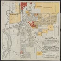
- Benton Harbor Improvement Association
- Published / Created:
- 1892?]
- Call Number:
- 811 B44 1892
- Container / Volume:
- BRBL_00553
- Image Count:
- 1
- Resource Type:
- Maps, Atlases & Globes
- Subject (Topic):
- Real property--Michigan--Benton Harbor
- Found in:
- Beinecke Rare Book and Manuscript Library > Benton Harbor : already a manufacturing, railroad and business center, is destined to speedily become one of the great cities of Michigan.
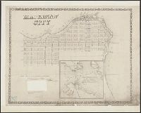
- Creator:
- Phillips, R. C. (Robert C.)
- Published / Created:
- 1857
- Call Number:
- 811 M21 1857
- Collection Title:
- Exposition of the natural position of Mackinaw City.
- Container / Volume:
- BRBL_00553
- Image Count:
- 1
- Resource Type:
- Maps, Atlases & Globes
- Subject (Topic):
- Real property--Michigan--Mackinaw City
- Found in:
- Beinecke Rare Book and Manuscript Library > Mackinaw City : from actual survey made August 1857 / by R.C. Phillips, surveyor.
- Published / Created:
- 1913
- Call Number:
- 811 D48 1913
- Container / Volume:
- BRBL_00553
- Image Count:
- 1
- Resource Type:
- Maps, Atlases & Globes
- Alternative Title:
- Map of the city of Detroit, Michigan
- Subject (Geographic):
- Detroit (Michigan)--Maps
- Found in:
- Beinecke Rare Book and Manuscript Library > R.L. Polk & Co.'s map of the city of Detroit, Michigan.