Skip to search
Skip to main content
Skip to first result
Search
You Searched For
Genre
Maps in books
Language
German
Language
Latin
New Search
Search Results
Creator:
Published / Created:
ca. 1750
Call Number:
1973 Folio 30
Collection Title:
[Atlas factice of 32 maps and 1 distance table, produced by the Homann Erben firm]
Image Count:
2
Publisher:
[Tobias Conrad Lotter?]
Subject (Geographic):
Chemnitz (Germany : Landkreis) --Maps --Early works to 1800 and Zwickau (Germany : Landkreis) --Maps --Early works to 1800
Subject (Topic):
Atlases, German --Early works to 1800
Collection Created:
[Nuremberg : s.n., 1701-1760]
Found in:
Beinecke Rare Book and Manuscript Library > Dynastiae comitat[us] Schoenbuirgici Penig, Remissa, Rochsburg, Wechselburg [cartographic material] : in clientela Elect. Saxon Glaucha, Hartenstein, Lichtenst. Stein, Waldenburg Praedia Benefic. S.R. Imp. ad circulum S.R.I. Saxoniae superiorem pertinente
Creator:
Published / Created:
ca. 1757
Call Number:
1973 Folio 30
Collection Title:
[Atlas factice of 32 maps and 1 distance table, produced by the Homann Erben firm]
Image Count:
2
Publisher:
[Tobias Conrad Lotter]
Subject (Geographic):
Saxony (Germany) --Maps --Early works to 1800
Subject (Topic):
Atlases, German --Early works to 1800
Collection Created:
[Nuremberg : s.n., 1701-1760]
Found in:
Beinecke Rare Book and Manuscript Library > Electoratus Saxonici Praefecturae Annaburgensis, Pretzschens[is] Torgaviensis, Schweinicensis, Muehlbergensis studio geographico / [cartographic material] / ita depictae, ut urbes, oppida, vici, pagi, aedes solitar cum vicinia accurate distingui possint a
Creator:
Published / Created:
[ca. 1758]
Call Number:
1973 Folio 30
Collection Title:
[Atlas factice of 32 maps and 1 distance table, produced by the Homann Erben firm]
Image Count:
2
Publisher:
Anjezo im Verlag bey Tobias Conrad Lotter, Geogr. ...
Subject (Geographic):
Saxony-Anhalt (Germany) --Maps --Early works to 1800
Subject (Topic):
Atlases, German --Early works to 1800
Collection Created:
[Nuremberg : s.n., 1701-1760]
Found in:
Beinecke Rare Book and Manuscript Library > Episcopatus Numburgensis et cizensis delineatio geographica adjectis praefecturis Portensi, Pegaviensi, Tautenburg et finitimis / [cartographic material] / cura Matth. Seutteri Geogr. Caes
Published / Created:
MDCI [1601]
Call Number:
Taylor 193 3
Collection Title:
Tertia pars Indiae Orientalis ... / de Germanico in Latinum translata, & bono ordine disposita a
Image Count:
1
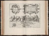
Description:
In pencil: Part 3. 31.
Subject (Geographic):
Saint Helena Island (S.C.)
Collection Created:
Francofurti : Excudebat Matthaeus Beckerus, anno MDCI [1601]
Found in:
Beinecke Rare Book and Manuscript Library > Insula D. Helenae ...
Published / Created:
MDCI [1601]
Call Number:
Taylor 193 3
Collection Title:
Tertia pars Indiae Orientalis ... / de Germanico in Latinum translata, & bono ordine disposita a
Image Count:
1
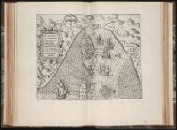
Description:
In pencil on veso: Part 2 p 18.
Subject (Geographic):
Mozambique --Maps --Early works to 1800
Collection Created:
Francofurti : Excudebat Matthaeus Beckerus, anno MDCI [1601]
Found in:
Beinecke Rare Book and Manuscript Library > Insulae et arcis Mocambique ...
Creator:
Published / Created:
1775
Call Number:
1983 Folio 23
Collection Title:
[Atlas factice of 50 maps, primarily by Johann Baptist Homann and/or issued by the Homann Erben
Image Count:
1
Publisher:
Impensis Homannianorum Haeredum
Subject (Geographic):
Bohemia (Czech Republic) --Maps --Early works to 1800, Galicia (Poland and Ukraine) --Maps --Early works to 1800, and Ukraine --Maps --Early works to 1800
Collection Created:
[Nuremberg : Homann Erben, 1710-1786]
Found in:
Beinecke Rare Book and Manuscript Library > Lubomeriae et Galliciae regni tabula geographica / [cartographic material] / F.I.G
Published / Created:
MDCI [1601]
Call Number:
Taylor 193 3
Collection Title:
Tertia pars Indiae Orientalis ... / de Germanico in Latinum translata, & bono ordine disposita a
Image Count:
1
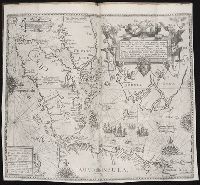
Description:
In pencil on verso: This map belongs part 2 p 48.
Subject (Geographic):
Borneo --Maps --Early works to 1800, Indonesia --Maps --Early works to 1800, and Java (Indonesia) --Maps --Early works to 1800
Collection Created:
Francofurti : Excudebat Matthaeus Beckerus, anno MDCI [1601]
Found in:
Beinecke Rare Book and Manuscript Library > Nova tabula insularum Iavae, Sumatrae, Borneonis ...
Creator:
Published / Created:
1746
Call Number:
1973 Folio 30
Collection Title:
[Atlas factice of 32 maps and 1 distance table, produced by the Homann Erben firm]
Image Count:
1
Alternative Title:
Mappe-monde qui represente les deux hemispheres savoir celui de l’orient et celui de l’occident, tiree des quatre cartes generales de feu M. le profess. Hasius, dressee par Mr. G.M. Lowitz et publiee par les Heritiers de Homann and Planiglobii terrestris mappa vniversalis
Description:
Map colored to show distribution of religions.
Publisher:
[Homann Erben]
Subject (Topic):
Atlases, German --Early works to 1800, Religion --Maps --Early works to 1800, and World maps --Early works to 1800
Collection Created:
[Nuremberg : s.n.,
Found in:
Beinecke Rare Book and Manuscript Library > Planiglobii terrestris mappa universalis utrumq[ue] hemisphaerium orient. et occidentale repraesentans, ex IV. mappis generalibus, Hasianis composita et adjectis ceteris hemisphaeriis / [cartographic material] / designata a G.M. Lowizio ; excudentibus Hom
Creator:
Published / Created:
MDCCLXXXIV [1784]
Call Number:
1983 Folio 23
Collection Title:
[Atlas factice of 50 maps, primarily by Johann Baptist Homann and/or issued by the Homann Erben
Image Count:
1
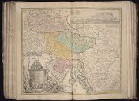
Alternative Title:
Representation du Cercle de Bas-Saxe, selon la desription geographique de Mons. Buesching, & d’autres Observations astronomiques
Publisher:
Impensis Homanniorum Herredum
Subject (Geographic):
Germany, Northern --Maps --Early works to 1800
Collection Created:
[Nuremberg : Homann Erben, 1710-1786]
Found in:
Beinecke Rare Book and Manuscript Library > Repraesentationem hancce Circuli Saxonici Inferioris [cartographic material] : ad mentem domini D. Buesching, et ex novissimis ac praestantissimis observationibus delineavit F. L. Guessefeld
Creator:
Published / Created:
[ca. 1715]
Call Number:
1983 Folio 23
Collection Title:
[Atlas factice of 50 maps, primarily by Johann Baptist Homann and/or issued by the Homann Erben
Image Count:
1
Publisher:
[Johann Baptist Homann]
Subject (Geographic):
Carniola (Slovenia) --Maps --Early works to 1800, Croatia --Maps --Early works to 1800, and Ljubljana (Slovenia) --Maps, Pictorial --Early works to 1800
Collection Created:
[Nuremberg : Homann Erben, 1710-1786]
Found in:
Beinecke Rare Book and Manuscript Library > Tabula Ducatus Carnioliae, vindorum Marchiae et Histriae et mente Mustr. quondam J.B. Valvasorii / concinnatia et exhibita a Io. Bapt. Homanno, S.C.M. Geogr
Branch:v1.61.6 ,Deployed:2024-06-12T09:55:36-04:00