Search
You Searched For
Search Results
- Call Number:
- 1974 Folio 72
- Collection Title:
- The English pilot: describing the West-India navigation, from Hudson's-Bay to the river Amazones
- Image Count:
- 1
- Found in:
- Beinecke Rare Book and Manuscript Library > A new and correct chart of the western and southern oceans
- Call Number:
- 1973 Folio 116
- Collection Title:
- The English pilot: describing the West-India navigation, from Hudson's-Bay to the river Amazones
- Image Count:
- 2
- Found in:
- Beinecke Rare Book and Manuscript Library > A new and correct chart of the western and southern oceans
- Call Number:
- 1973 Folio 114
- Collection Title:
- The English pilot: describing the West-India navigation, from Hudson's-Bay to the river Amazones
- Image Count:
- 1
- Resource Type:
- Maps, Atlases & Globes
- Found in:
- Beinecke Rare Book and Manuscript Library > A new and correct chart of the western and southern oceans ...
- Creator:
- Harris, I., d. 1739
- Call Number:
- 1978 Folio 10
- Collection Title:
- The English pilot: describing the West-India navigation, from Hudson's-Bay to the river Amazones
- Image Count:
- 1
- Found in:
- Beinecke Rare Book and Manuscript Library > A new and correct chart shewing the variations of the compass in the western & southern oceans
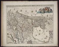
- Published / Created:
- Undated
- Call Number:
- 1976 1233
- Collection Title:
- Twenty four new and accurate maps of the several parts of Europe ... : all (except the last) new
- Image Count:
- 1
- Found in:
- Beinecke Rare Book and Manuscript Library > A new map of Europe according to ye newest observations
- Creator:
- Faden, William, 1749-1836, creator
- Published / Created:
- 1788 June 24
- Call Number:
- 1982 Folio 10
- Image Count:
- 2
- Found in:
- Beinecke Rare Book and Manuscript Library > A new map of the German empire and the neighbouring states with their principal post roads : originally published by the Royal Academy of Berlin
- Creator:
- Visscher, Nicolaes, 1649-1702
- Published / Created:
- ca. 1684
- Call Number:
- Folio 469
- Collection Title:
- [Atlas factice of 13 maps by Nicolaes Visscher I, Nicolaes Visscher II, Guillaume Sanson, and
- Image Count:
- 1
- Found in:
- Beinecke Rare Book and Manuscript Library > Belgium Foederatum / [cartographic material] / emendate auctum et novissime editum, per Nicolaum Visscher
- Creator:
- Visscher, Nicolaes, 1649-1702
- Published / Created:
- ca. 1684
- Call Number:
- Folio 469
- Collection Title:
- [Atlas factice of 13 maps by Nicolaes Visscher I, Nicolaes Visscher II, Guillaume Sanson, and
- Image Count:
- 1
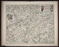
- Found in:
- Beinecke Rare Book and Manuscript Library > Comitatus Hannoniae et Archiepiscopatus Cameracensis tabula / [cartographic material] / per Nicolaum Visscher
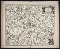
- Creator:
- Danckerts, Justus, 1635-1701
- Published / Created:
- ca. 1680
- Call Number:
- Folio 469
- Collection Title:
- [Atlas factice of 13 maps by Nicolaes Visscher I, Nicolaes Visscher II, Guillaume Sanson, and
- Image Count:
- 1
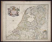
- Found in:
- Beinecke Rare Book and Manuscript Library > Comitatus Hollandiae tabula / [cartographic material] / pluribus locis recens emendata a Iusto Danckerts
- Creator:
- Visscher, Nicolaes, 1649-1702
- Published / Created:
- ca. 1684
- Call Number:
- Folio 469
- Collection Title:
- [Atlas factice of 13 maps by Nicolaes Visscher I, Nicolaes Visscher II, Guillaume Sanson, and
- Image Count:
- 1
- Found in:
- Beinecke Rare Book and Manuscript Library > Comitatus Namurci / [cartographic material] / emendata delineatio nuperrime in lucem edita per Nicolaum Visscher