The natural history of Carolina, Florida, and the Bahama Islands : containing the figures of birds
Image Count:
1
Description:
Following p. 100.
Subject (Geographic):
Bahamas --Natural history, Florida --Natural history, North Carolina --Natural history, and South Carolina --Natural history
Subject (Topic):
Natural history --Bahamas, Natural history --North Carolina, Natural history --Pictorial works, Natural history --Pre-Linnean works, Natural history --South Carolina, and Natural history --Southern States
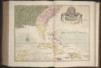
Forty-two new maps of Asia, Africa, and America ... : all engrav’d, according to the latest
Image Count:
1
Alternative Title:
Chili, Patagonia, part of La Plata &c
Description:
In pencil on verso: 27. and Table of contents for maps 2-20 in section "America" misnumbered.
Subject (Geographic):
Chile --Maps --Early works to 1800, Patagonia (Argentina and Chile) --Maps --Early works to 1800, South America --Maps --Early works to 1800, and Tierra del Fuego (Argentina and Chile)
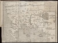
Forty-two new maps of Asia, Africa, and America ... : all engrav’d, according to the latest
Image Count:
1
Alternative Title:
Mexico, or New Spain
Description:
In pencil on verso: 33. and Table of contents for maps 2-20 in section "America" misnumbered.
Subject (Geographic):
California --Maps --Early works to 1800, Central America --Maps --Early works to 1800, Florida --Maps --Early works to 1800, Louisiana --Maps --Early works to 1800, Mexico --Maps --Early works to 1800, and New Mexico --Maps
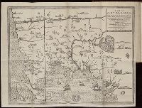
The present state of New-England ; being a narrative of the troubles with the Indians in New
Image Count:
2
Description:
Imperfect: map wanting and supplied in facsimile; only a remnant of original map remains. This copy has what is considered the correct map for this edition, the mound immediately beneath the title being designated as "The Wine Hills", the Boston edition h
Subject (Geographic):
New England --History --Colonial period, ca. 1600-1775
Subject (Topic):
Indians of North America --New England, King Philips War, 1675-1676., and Pequot War, 1636-1638.
Available also through the Library of Congress Web site as a raster image., BEIN 2003 Folio 85: No. 1 of 45 maps bound together with binder's spine title: Atlas of America; ms. table of contents. Bookplate: Robinson. Bookplate of Paul Mellon., by J. Palairet, with considerable alterations & improvements from d'Anville, Mitchell & Bellin, by L. Delarochette., Differs from other copy in coloration. Only boundaries are colored, emphasis is on showing the internal boundaries of British America., Hand colored., Includes historical notes and table of Methodical divisions of North America., LC Maps of North America, 1750-1789,, Longit. west from Ferro I., Printed for John Bowles at the Black Horse in Cornhill & Carington Bowles in St. Pauls Church yard, London., Relief shown pictorially., Scale [ca. 1:15,000,000]., and Sterling copy stamped on verso: Yale, Horace Brown, 1900S.