Skip to search
Skip to main content
Skip to first result
Search
You Searched For
Genre
Maps in books
New Search
Search Results
Creator:
Published / Created:
[1700?]
Call Number:
1973 Folio 10
Image Count:
1
Resource Type:
Maps, Atlases & Globes
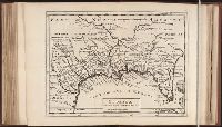
Description:
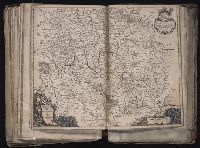
Appears in Schenk's Atlas contractus [ca. 1700]., Bar scales in milliaria Germanica communia, milliaria Gallica sive horae itineris, milliaria Italia, and milliaria Anglica., Ferro meridian., Includes decorative vignette in upper left of map., No. 48 of 69 maps bound together in composite atlas., Relief shown pictorially., and Scale [ca. 1:330 000].
Publisher:
[Peter Schenck]
Subject (Geographic):
Belgium --Maps --Early works to 1800 and Flanders --Maps --Early works to 1800
Found in:
Beinecke Rare Book and Manuscript Library > Flandriae comitatus : in suastoparchias optime distinctus, una cum vicinis et finitimis
Creator:
Published / Created:
[1732]
Call Number:
E1015 M66 1732
Collection Title:
Atlas minor: or a set of sixty-two new and correct maps, of all parts of the world. All composed
Image Count:
1
Description:
Autograph of Gravely. Autograph of Baldock. Autograph of Aston. Autograph of W. Alington.
Subject (Geographic):
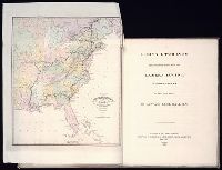
America--Maps--Early works to 1800
Subject (Topic):
Atlases--Early works to 1800
Collection Created:
London :
Found in:
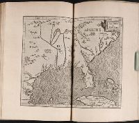
Beinecke Rare Book and Manuscript Library > Florida called by ye French Louisiana & c. By H. Moll geographer.
Call Number:
Taylor 210
Collection Title:
Chronologicarvm demonstrationvm libri tres. Ioannis Temporarii. Qvorvm primo, temporum series, a
Image Count:
1
Description:
Between p. 176-177.
Subject (Geographic):
America --Maps --Early works to 1800 and Florida --Maps --Early works to 1800
Subject (Topic):
Chronology and Southern States --Maps --Early works to 1800
Collection Created:
Francofvrti, pud Andreae Wecheli heredes, Claudium Marnium, & ioan. Aubrium, 1596
Found in:
Beinecke Rare Book and Manuscript Library > Florida et Apalche
Published / Created:
1640
Call Number:
C16 015h
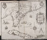
Collection Title:
Lhistoire dv Nouveau monde on Description des Indes Occidentales, contenant dix-huit liures / par
Image Count:
1
Description:
Between p. 102-103 and Scale: Miliaria Germanica
Subject (Geographic):
Florida
Subject (Topic):
America --Discovery and exploration and West Indies --Description and travel.
Collection Created:
A Leyde : Chez B. & A. Elseuiers, 1640
Found in:
Beinecke Rare Book and Manuscript Library > Florida, et regiones vicinae
Call Number:
Taylor 192 1-3
Collection Title:
Brevis narratio eorvm qvae in Florida Americae provicia Gallis acciderunt, secunda in illam
Container / Volume:
Pt. 2
Image Count:
1
Description:
Following title page for Part 2.
Subject (Geographic):
Florida --Description and travel and Florida --History --Huguenot colony, 1562-1565
Subject (Name):
Le Moyne de Morgues, Jacques, d. 1588. Brevis narratio
Subject (Topic):
Indians of North America --Florida
Collection Created:
Francoforti ad Moenvm, Typis I. Wecheli, sumtibus vero T. de Bry, venales reperiuntur in officina S. Feierabedii, 1591
Found in:
Beinecke Rare Book and Manuscript Library > Floridae Americae Provinciae
Creator:
Published / Created:
1829
Call Number:
Egf +827G
Image Count:
4
Resource Type:
Prints & Photographs
Publisher:
Cadell & co. [etc.],
Subject (Geographic):
Canada--Pictorial works, Georgia--Description and travel, United States--Aerial views, and United States--Pictorial works
Subject (Name):
Creek Indians
Subject (Topic):
Camera lucida and Indians of North America--Georgia
Found in:
Beinecke Rare Book and Manuscript Library > Forty etchings : from sketches made with the camera lucida, in North America, in 1827 and 1828 ... / By Captain Basil Hall.
Creator:
Published / Created:
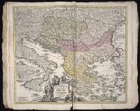
[ca. 1680?]
Call Number:
1983 Folio 19
Collection Title:
[Atlas factice of 96 maps by Blaeu, Visscher, Jansson, Hondius and others]
Image Count:
1
Description:
Imperfect: mutilated along edges, with some loss of cartouche and bar scale engravings, reproduced in ms. Reinforced along edges with manuscript and printed waste. Sheet measures 41.7 x 53.7 cm. No. 75 of 92 maps bound together. and Numbered 81 [76, cancelled] on verso.
Publisher:
Johannes Janssonius excud
Subject (Geographic):
Franconia (Germany) --Maps --Early works to 1800
Collection Created:
[1556-1680]
Found in:
Beinecke Rare Book and Manuscript Library > Franconiae nova descriptio
Branch:v1.61.6 ,Deployed:2024-06-12T09:55:36-04:00