Search
You Searched For
Search Results
- Creator:
- Barber, John Warner, 1798-1885
Brown, Samuel E., -approximately 1860
- Published / Created:
- 1839?]
- Call Number:
- 1977 2018
- Image Count:
- 21
- Subject (Geographic):
- Massachusetts --Maps
- Found in:
- Beinecke Rare Book and Manuscript Library > Dorr, Howland & Co., Worcester Mass. propose to publish by subscription, a work entitled Massachusetts historical collections : being a general collection of interesting facts, traditions, biographical sketches, anectdotes, etc. relating to the history and antiquities of every town in Massachusetts, with geographical descriptions / illustrated by a map and two hundred engravings ; by John Warner Barber.
- Published / Created:
- 1774 November 29
- Call Number:
- 1975 Folio 51
- Collection Title:
- The American atlas; or, A geographical description of the whole continent of America; wherein are
- Image Count:
- 1
- Resource Type:
- Maps, Atlases & Globes
- Subject (Geographic):
- Massachusetts --Maps --Early works to
- Found in:
- Beinecke Rare Book and Manuscript Library > A map of the most inhabited part of New England, containing the provinces of Massachusets Bay and New Hampshire, with the colonies of Conecticut and Rhode Island, divided into counties and townships: the whole composed from actual surveys and its situatio
- Creator:
- Smith, John, 1580-1631
- Published / Created:
- 1631
- Call Number:
- Taylor 316
- Image Count:
- 2
- Subject (Geographic):
- Massachusetts--Maps--Early works to
- Found in:
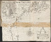
- Beinecke Rare Book and Manuscript Library > Advertisements for the unexperienced planters of New-England, or anywhere, or, The path-way to experience to erect a plantation : With the yearely proceedings of this country in fishing and planting, since the yeare 1614. to the yeare 1630. and their present estate. Also how to prevent the greatest inconveniences, by their proceedings in Virginia, and other plantations, by approved examples. With the countries armes, a description of the coast, harbours, habitations, land-markes, latitude and longitude: with the map, allowed by our royall King Charles. By Captaine Iohn Smith, sometimes governour of Virginia, and admirall of Nevv-England.
- Creator:
- Eddy, J.
Lowe, George, fl. 1613?-ca. 1615?
- Published / Created:
- 1614-16
- Call Number:
- Zd 176
- Collection Title:
- Path-way to experience to erect a plantation
- Image Count:
- 1
- Subject (Geographic):
- Massachusetts --Maps --Early works to
- Found in:
- Beinecke Rare Book and Manuscript Library > New England: the most remarqueable parts thus named by the high and mighty Prince Charles, Prince of Great Britaine